

The history of the Inca Trail traces its construction to the fifteenth and early sixteenth centuries under the authority of the Inca Empire. The trail formed part of the Qhapaq Ñan imperial road system, a vast network extending across the Andes to unite administrative centers, agricultural regions, and ceremonial hubs. Engineers shaped stone-paved paths, stairways, tunnels, bridges, and drainage systems to support movement across steep mountains and cloud forests. The primary purpose focused on connecting major cities and provincial settlements to Cusco, reinforcing political control and economic coordination. Trade relied on the trail for transporting maize, textiles, ceramics, and metal goods through relay stations known as tambos. Religious pilgrimage represented another central function, with routes guiding travelers toward sacred landscapes and ritual destinations, including Machu Picchu. Military mobility played a strategic role, allowing rapid troop deployment to defend borders and suppress uprisings across the empire. Sections of the route fell into disuse while remote segments remained intact due to geographic isolation after the Spanish conquest.
Twentieth-century archaeological surveys documented surviving pathways, terraces, and ceremonial structures, leading to systematic conservation efforts. Modern preservation focuses on controlled access, mandatory permits, trail maintenance, and environmental protection to prevent erosion and cultural loss. International recognition followed through designation as part of a United Nations Educational, Scientific, and Cultural Organization (UNESCO) World Heritage area, highlighting global historical value and engineering achievement. Contemporary stewardship balances tourism with conservation to protect archaeological integrity and surrounding ecosystems while sustaining local communities tied to cultural heritage, such as the Inca Trail.
Inca Trail Tours Review
These Inca Trail reviews share firsthand experiences from travelers who completed the legendary hike to Machu Picchu, highlighting trail conditions, cultural insights, scenery, organization, and the unforgettable arrival at the Lost City of the Incas.

Average Rating
Out of 5
Happy Travelers
Since 2015
Tours Completed
In the past 12 months
Recommend Rate
Would book again or refer others
The Inca Trail is historically and culturally significant because it functioned as a sacred ceremonial route within the Inca Empire, directly linking important religious, administrative, and agricultural centers to Machu Picchu. The trail formed part of the vast Qhapaq Ñan road system, which unified the empire politically, economically, and spiritually across the Andes. Use of the route was restricted during the Inca period, reserved primarily for nobility, priests, and official processions, reinforcing its ritual importance.
Archaeological sites along the Inca Trail demonstrate advanced Inca engineering and cosmology. Structures such as Wiñay Wayna, Phuyupatamarca, and Intipata reveal ceremonial platforms, water channels, terraces, and astronomical alignments tied to solar worship and agricultural cycles. Stonework precision, drainage systems, and stair construction reflect sophisticated adaptation to steep mountain environments. The final approach through the Sun Gate (Inti Punku) highlights a symbolic arrival at Machu Picchu, timed with sunrise rituals and seasonal significance. The Inca Trail represents Inca beliefs connecting landscape, spirituality, and governance. Mountains, rivers, and pathways were considered sacred entities, and travel along the trail held ceremonial meaning rather than serving only transportation purposes.
The Inca Trail was important in Inca civilization because it served as a political, economic, religious, and strategic artery that supported imperial control and cultural unity across the Andes. The trail formed part of the Qhapaq Ñan road network, allowing state officials and messengers to travel efficiently between regional centers and the capital, Cusco, which strengthened centralized governance and administrative oversight. The Inca Trail enabled the transport of goods, including agricultural produce, textiles, and ceremonial items, between ecological zones. Porters known as chasquis carried messages and supplies along the route, ensuring rapid communication and redistribution of resources across the empire. Storage facilities near the trail supported state-managed logistics and food security.
The trail functioned as a sacred route used for ceremonial pilgrimages to Machu Picchu and other ritual sites. Travel along the trail held symbolic meaning connected to solar worship, mountain deities, and seasonal cycles, reinforcing spiritual authority and cultural identity. The Inca Trail supported the strategic movement of troops and supplies through difficult terrain from a military perspective. Elevated routes and controlled access points improved surveillance and defensive coordination across the empire.
The Inca Trail was originally used as a ceremonial, administrative, and communication route within the Inca Empire rather than as a common travel path. The trail formed part of the larger Qhapaq Ñan road system and connected important religious sites, administrative centers, and imperial estates to Machu Picchu. Access to the route was restricted, and use was primarily reserved for Inca nobility, priests, state officials, and selected messengers.
The Inca Trail supported imperial control by enabling officials to move efficiently through mountainous terrain administratively and politically. Chasqui messengers carried information, orders, and small goods along the trail, allowing rapid communication across regions. Strategically placed waystations and storage facilities supported state logistics and governance. The trail functioned as a sacred pilgrimage route religiously. Travel along the path held symbolic meaning connected to sun worship, mountain deities, and ritual ceremonies. Archaeological complexes along the route served ceremonial, astronomical, and agricultural purposes, reinforcing spiritual authority and cultural identity. The trail allowed controlled troop movement and surveillance through elevated terrain, supporting defense and territorial management from a military perspective.
The Inca Trail is considered so special because it uniquely combines ancient history, sacred geography, and a direct ceremonial approach to Machu Picchu that no other route offers. The trail follows original Inca pathways built for ritual, governance, and imperial movement, preserving stone steps, tunnels, terraces, and drainage systems that demonstrate exceptional engineering adapted to extreme mountain terrain.
Cultural significance elevates the experience beyond hiking. Archaeological complexes along the route (Wiñay Wayna, Phuyupatamarca, Intipata) reveal religious practices tied to solar worship, agriculture, and mountain deities. The final entry through Inti Punku (Sun Gate) provides a symbolic arrival at Machu Picchu aligned with Inca cosmology and ceremonial timing, reinforcing the spiritual purpose of the journey.
Natural diversity adds to its uniqueness. The trail passes cloud forest, alpine passes, and river valleys within a compact distance, creating constant environmental change. High altitude sections intensify physical and mental demands, strengthening the sense of achievement upon completion. Strict permit limits protect archaeological integrity and environmental balance, preserving authenticity and preventing overuse. Guided access ensures historical context and conservation standards.
The Inca Trail was first hiked in the modern era in the early 20th century, following the rediscovery of Machu Picchu in 1911. The Inca Trail fell into disuse after the Spanish conquest and remained largely hidden by vegetation for centuries, although the trail was built and used by the Inca civilization in the 15th century for ceremonial, administrative, and strategic purposes.
Modern exploration of the Inca Trail began when expeditions led by Hiram Bingham documented Machu Picchu and the surrounding Inca infrastructure between 1911 and 1915. Archaeologists and local guides traced sections of the ancient route while studying nearby ruins, terraces, and stone paths. The early explorations marked the first recorded modern hikes along portions of the trail, although the route was not yet organized or continuous for trekking. Systematic archaeological research and trail clearing continued throughout the mid 20th century. The full route became better mapped and accessible, leading to its development as a regulated trekking path by the 1970s. Government protection measures were followed to preserve cultural heritage and control visitor impact.
The Inca Trail is unique compared to other ancient trails because it combines an intact ceremonial route, advanced mountain engineering, and a direct sacred arrival at Machu Picchu, which few historical paths offer. Ancient trails served trade or military movement, while the Inca Trail functioned as a ritual and imperial pathway, reserved for nobility, priests, and official processions rather than daily transport. Stone steps, tunnels, terraces, and drainage systems remain largely preserved, demonstrating precise engineering adapted to steep Andean terrain.
The Inca Trail follows a purpose-built spiritual journey with carefully placed archaeological complexes aligned to astronomy, agriculture, and religious belief. Sites along the trail form a continuous narrative leading to Machu Picchu, culminating at Inti Punku (Sun Gate), a symbolic entrance for ceremonial timing rather than logistical convenience. Environmental diversity adds to its distinction. The trail passes cloud forest, alpine passes, and high mountain ridges within a compact distance, intensifying physical and mental demands while reinforcing the spiritual progression of the route. Strict permit controls preserve authenticity and limit modern alteration.
The Inca Trail was built by the Inca civilization during the 15th century as part of the expansive Qhapaq Ñan imperial road system. The Incas were highly skilled builders who engineered roads across extreme Andean terrain without metal tools, wheeled transport, or draft animals. Construction relied on precise stone cutting, manual labor, and deep knowledge of geology, climate, and topography.
Trail construction techniques reflected advanced engineering principles. Builders carved stone staircases directly into mountainsides, leveled paths across steep slopes, and used retaining walls to stabilize soil and prevent erosion. Drainage channels were integrated beneath and alongside the trail to control water flow during heavy rainfall, preserving structural integrity over centuries. The Incas constructed terraces and switchbacks to reduce the gradient and improve safety in steep or unstable areas.
Stonework followed dry masonry techniques, fitting stones tightly without mortar, which allowed flexibility during earthquakes and temperature changes. Routes were carefully aligned to avoid landslide-prone zones while maintaining access to ceremonial and administrative sites. The trail network included rest stations, storage facilities, and checkpoints that supported long-distance travel and state organization.
The Inca Trail is located in southern Peru, within the Cusco Region of the Andean highlands. The trail runs northwest from areas near Cusco toward Machu Picchu, crossing protected zones of the Andes Mountains and ending inside the Historic Sanctuary of Machu Picchu. The route follows ancient Inca pathways that connect high mountain terrain with lower cloud forest environments.
The Inca Trail passes through a diverse landscape shaped by mountains, valleys, and rivers. The route climbs over high passes such as Dead Woman Pass, descends into forested valleys, and traverses ridges overlooking the Urubamba River Valley, known as the Sacred Valley. Sections of the trail cut across steep mountain slopes, while others follow natural contours above river systems fed by Andean glaciers and rainfall. The trail moves through distinct ecological zones, beginning in high-altitude alpine terrain and transitioning into cloud forest, where humidity increases, and vegetation becomes denser. The geographic variation explains the trail’s complex engineering, including stone staircases, drainage channels, and terraces designed to withstand erosion and landslides.
The Inca Trail is located in Peru. The trail lies within the Peruvian Andes near Cusco and forms part of the historic network of Inca roads that connected sacred, administrative, and agricultural centers of the empire. Peru preserves the Inca Trail as a protected cultural heritage route because it represents advanced Inca engineering, ceremonial traditions, and the spiritual connection between landscape and civilization. Strict regulation, conservation policies, and guided access reflect Peru’s commitment to safeguarding the trail’s archaeological integrity and national identity.
The Inca Trail leads to Machu Picchu by following an original Inca ceremonial route that progresses through mountain passes, valleys, and sacred archaeological sites before entering the citadel from the east. The route begins in the Andean highlands near Cusco, passes through controlled checkpoints and designated camps, and crosses varied terrain that includes stone staircases, cloud forest paths, and high elevation passes such as Dead Woman Pass. The trail connects ritual and administrative complexes that prepared travelers spiritually and symbolically for arrival at Machu Picchu. The final approach occurs at Inti Punku (Sun Gate), where the first panoramic view of Machu Picchu appears, reinforcing the ceremonial importance of the journey rather than simple physical access. The controlled progression reflects the trail’s original function as a pilgrimage path reserved for nobles and priests, culminating in a ritual entrance timed with solar and seasonal significance, defining the historic route known as the Inca Trail to Machu Picchu.
The main routes of the Inca Trail are listed below.
- Classic Inca Trail (4-Day Route): The Classic Inca Trail covers 43 kilometers and represents the original ceremonial route used by the Incas. The trail crosses high mountain passes, cloud forest, and major archaeological sites before entering Machu Picchu through the Sun Gate. Steep stone staircases, uneven terrain, and high elevation define the physical challenge of the route.
- Short Inca Trail (2-Day Route): The Short Inca Trail follows the final section of the ancient path and spans roughly 12 kilometers. The route includes key sites such as Wiñay Wayna and finishes at Machu Picchu through the Sun Gate, offering historical value with reduced physical demand compared to the full trek.
- Combined Inca Trail Variations: Itineraries combine sections of the Inca Trail with rail or road access before reconnecting to the final ceremonial segment. The routes preserve the symbolic entrance to Machu Picchu while shortening hiking distance, belonging to the Inca Trail Map and Routes.

What are Key Sites Along the Inca Trail?


Llaqtapata
Llactapata stands as an early ceremonial and residential complex positioned near the
Cusichaca River.Stone terraces and building foundations demonstrate agricultural planning and ritual activity integrated into the surrounding terrain. The site introduces early Inca settlement design and land management principles along the trail.
Key Features


Dead Woman’s Pass (Warmiwañusca)
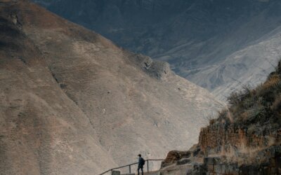
Dead Woman’s Pass marks the highest elevation point along the Inca Trail. Alpine landscapes and exposed ridgelines emphasize the physical demands faced by travelers crossing the Andes. The pass functions as a symbolic and physical threshold rather than a residential site.
Key Features


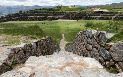
Runkurakay
Runkurakay consists of a circular stone structure built into a mountain slope. The architectural form indicates use as a resting station and control post overseeing trail movement. Elevated positioning reflects defensive awareness and logistical planning.
Key Features


Sayacmarca
Sayacmarca rises dramatically along a narrow ridge above the Urubamba Valley. Stone stairways, defensive walls, and ceremonial platforms reveal administrative and strategic functions. The compact layout reflects adaptation to steep terrain and limited space.
Key Features


Phuyupatamarca
Phuyupatamarca occupies a high elevation zone frequently surrounded by cloud cover. Water channels, fountains, and terraces demonstrate sophisticated hydraulic engineering and ceremonial water use. The site reflects spiritual and functional design integrated into mountain ecology.
Key Features


Wiñay Wayna
Wiñay Wayna features extensive agricultural terraces and residential structures built into steep slopes. The scale of construction indicates long-term habitation and food production. Proximity to Machu Picchu reinforces the site’s logistical importance along the route.
Key Features


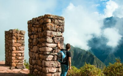
Inti Punku (Sun Gate)
Inti Punku functions as the ceremonial entrance to Machu Picchu. Elevated positioning frames the first panoramic view of the citadel for trail travelers. Stone construction aligns with solar observation and symbolic arrival rituals.
Key Features
The different types of Inca Trails are listed below.
- Classic Inca Trail: The Classic Inca Trail represents the most well-known route. Stone-paved paths connect major ruins, ceremonial centers, mountain passes, and Inti Punku before reaching Machu Picchu. Government permits and daily visitor limits regulate access to preserve archaeological integrity.
- Short Inca Trail: The Short Inca Trail offers a condensed experience. The route focuses on Wiñay Wayna and Inti Punku while requiring less time and physical endurance. Entry suitability aligns with travelers seeking archaeological highlights without extended high-altitude trekking.
- Salkantay Trail: A primary or combined route alternative to the Classic Trail. The Salkantay Trail follows high-altitude landscapes near Mount Salkantay. Glacial lakes, alpine valleys, and limited archaeological sites define the route. Elevation exposure and climate variation characterize the physical demands of the trail.
- Inca Jungle Trail: The Inca Jungle Trail combines trekking with varied terrain. Jungle paths, cycling segments, and river valleys characterize the route with fewer Inca structures. Adventure-focused activities distinguish the trail from historically concentrated routes.
The Inca Trail starts at Kilometer 82 near Ollantaytambo along the Cusco–Aguas Calientes railway, where controlled checkpoints verify permits, passports, and registered trekking groups. The route follows a preserved section of the Qhapaq Ñan imperial road system, featuring stone paving, drainage channels, staircases, and retaining walls engineered for sustained mountain travel. Elevation changes guide travelers through dry valleys, cloud forests, and high passes while revealing ceremonial centers, agricultural terraces, and administrative waystations. The final approach passes through Inti Punku, positioned as a ceremonial gateway aligned with ritual movement toward the citadel. The trail concludes at Machu Picchu, a fortified mountain settlement that served religious, political, and residential functions within the Inca Empire.
The Inca Trail trek ranks as moderately difficult to challenging. The route covers 42 kilometers, reaches a maximum altitude of about 4,215 meters at Dead Woman’s Pass, and traverses stone staircases, uneven paving, steep ascents, and descents across multiple ecological zones. The average duration spans four days, with daily hiking times ranging from five to eight hours depending on pace and acclimatization. Physical demands increase due to altitude exposure, variable weather conditions, and continuous elevation changes rather than technical climbing. Proper preparation focuses on cardiovascular conditioning, leg strength training, gradual altitude acclimatization in the Cusco region, and appropriate gear selection for rain, cold nights, and extended walking, explaining How Hard is the Inca Trail?
When is the Best time to Hike the Inca Trail?
The best time to hike the Inca Trail occurs during the dry season from May through September. The period from May through September offers stable weather, lower rainfall, clearer mountain views, and safer footing on stone steps and high passes along the route to Machu Picchu. Peak conditions appear from June through August, when daytime temperatures remain moderate and nighttime temperatures drop at higher elevations, increasing comfort for sustained trekking. Shoulder months such as May and September provide fewer crowds while maintaining favorable trail conditions and consistent visibility across cloud forest and alpine zones, learn more about the Best Time to do Inca Trail.
0 Comments