
Inca Trail elevation impacts the hiking experience from a tourist perspective. The Inca Trail elevation presents challenges that require physical preparation and acclimatization to avoid altitude sickness. Hiking at high altitudes impacts health by reducing oxygen levels, which leads to fatigue and difficulty breathing.
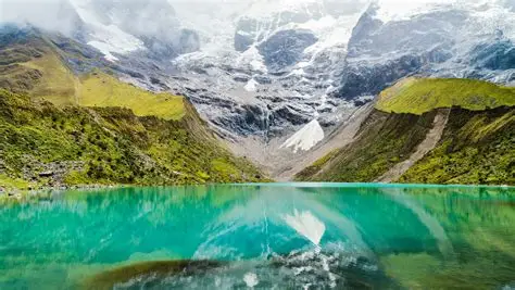
The Inca Trail is located in the Andes Mountains of Peru and offers breathtaking views while linking trekkers to the historic Machu Picchu. The varied elevations along the trail provide physical and mental challenges, making the hike a rewarding adventure for trekkers prepared for the climb. Understanding elevation and how it affects the demands of the Inca Trail improves the hiking experience.


Inca Trail Tours Review
These Inca Trail reviews share firsthand
experiences from travelers who completed the legendary hike to Machu Picchu, highlighting
trail conditions, cultural insights, scenery, organization, and the unforgettable arrival at the
Lost City of the Incas.

Average RatingOut of 5
Satisfied TrekkersSince 2014
Treks CompletedDuring the past year
Recommend RateRepeat booking intent
The trek features multiple passes exceeding 3,600 meters. Dead Woman’s Pass marks the zenith of the route at 4,215 meters. Runkurakay Pass sits at a slightly lower altitude of 3,950 meters. The trail descends to the Machu Picchu citadel at 2,430 meters. The variations create a demanding physical experience for every trekker. The final destination of Machu Picchu stands at 2,430 meters (7,970 feet). The varying elevations challenge hikers, with the highest point being particularly demanding. Proper acclimatization is necessary to adjust to the altitude changes along the Inca Trail.
Visibility from the top depends heavily on the prevailing weather conditions. Clouds obscure the view during the wet season months. The descent from the peak drops steeply into the Pacaymayo valley. Temperatures at the summit remain low throughout the year. Warmiwañusca stands as the most challenging obstacle on the ancient route.
The key elevation points along the Inca Trail are listed below.
- Cusco City (3,399 m / 11,152 ft): The acclimatization hub for travelers before starting the trek.
- Piscacucho or Km 82 (2,600 m / 8,530 ft): The official starting checkpoint of the Classic Inca Trail.
- Wayllabamba Camp (3,000 m / 9,842 ft): The first major campsite located at a moderate altitude.
- Dead Woman’s Pass (4,215 m / 13,828 ft): The highest peak of the journey with minimal oxygen levels.
- Runkurakay Pass (3,950 m / 12,960 ft): The second-highest mountain pass featuring circular Inca ruins.
- Phuyupatamarca (3,670 m / 12,040 ft): The “Town in the Clouds” with panoramic views.
- Wiñay Wayna (2,650 m / 8,694 ft): The final campsite before reaching Machu Picchu.
- Intipunku / Sun Gate (2,720 m / 8,924 ft): The entrance gate offering the first view of Machu Picchu.
The elevation of Huayna Picchu is 2,693 meters (8,835 feet). The mountain is located behind Machu Picchu, offering some of the iconic views of the archaeological site. Trekkers hiking to the summit encounter a steep ascent with narrow, exposed paths that feature sections of stairs and handrails.The trail is considered challenging, with a vertical ascent that takes anywhere from 1 to 2 hours to complete, depending on the hiker’s pace. Trekkers are rewarded with spectacular views of Machu Picchu, the Urubamba River, and the surrounding Andean mountains once they reach the top.
Trekkers must be prepared for the Huayna Picchu climb, which offers an unparalleled vantage point sought after by visitors to the region.
The Dead Woman’s Pass altitude is 4,215 meters (13,828 feet). Dead Woman’s Pass presents the greatest physical challenge of the trek, where oxygen availability drops to nearly 60% of sea level.The pass separates the Wayllabamba Valley from the Pacaymayo Valley, and reaching this milestone marks a significant achievement for every hiker on the Inca Trail.
The net elevation change from the start at Km 82 to Machu Picchu is a loss of 170 meters. The cumulative gain defines the true difficulty. Ascending two major passes adds thousands of vertical meters to the exertion load. Muscles fatigue rapidly under the strain of continuous climbing. Proper training mitigates the impact of the total ascent.
Trekkers gain 500 meters (1,640 feet) on the first day, reaching the first major campsite at Wayllabamba. Trekkers face the steepest ascent on the second day, gaining over 1,500 meters (4,921 feet) to reach Dead Woman’s Pass, the highest point at 4,215 meters (13,828 feet). The third day involves a descent, with a smaller elevation gain of around 400 meters (1,312 feet) before reaching Wiñay Wayna. The final day sees a smaller ascent to the Sun Gate before descending to Machu Picchu. Cumulative elevation gain and daily segment increases emphasize the need for careful pacing and acclimatization throughout the trek.
Seasonal considerations play a critical role in how elevation impacts hiking on the Inca Trail. Clear skies and lower humidity make trekking more comfortable during the dry season (May to September), though temperatures still drop significantly at higher altitudes. The rainy season (November to March) brings more unpredictable weather, with an increased risk of slippery trails and cooler, damp conditions at higher elevations. Trekkers must be prepared for the variations by dressing in layers and ensuring proper gear for the changing weather, as well as allowing time for acclimatization to the elevation changes along the trail.
Oxygen levels fluctuate in tandem with the changing weather patterns. Cold air at the passes feels thinner and makes breathing more difficult. Fog and mist at intermediate elevations dampen clothing and cool the body. The sun burns more intensely at high altitudes due to the thinner atmosphere. Managing body temperature becomes vital for comfort and safety.
The steepness of the trail near passes increases the difficulty. Sections with sharp ascents and declines require careful footing and significant stamina. Trekking for 2 to 4 days in unpredictable weather adds to the challenge. The varying elevations from the starting point at 2,600 meters (8,530 feet) to the endpoint at Machu Picchu impact energy levels, making rest and proper acclimatization essential. Long daily hikes exceeding eight hours exacerbate the physical toll. Understanding the Inca Trail difficulty helps trekkers mentally prepare for the trek’s demanding nature, particularly at higher altitudes.
To prepare for the elevation of the Inca Trail, follow the six steps below.
- Acclimatize Early: Arrive in Cusco at least two days before the trek begins.
- Practice Cardio: Engage in aerobic exercises such as running or swimming.
- Hydrate Frequently: Drink plenty of water to counteract altitude effects.
- Hike Locally: Train on hills or stairs to simulate steep terrain.
- Consult Doctors: Discuss medication options such as Acetazolamide.
- Rest Well: Ensure adequate sleep before starting the trek.
To manage altitude sickness on the Inca Trail, follow the six steps listed below.
- Descend Immediately: Move to a lower altitude if symptoms become severe.
- Drink Water: Maintain hydration throughout the hike.
- Chew Coca: Use coca leaves or tea to alleviate mild symptoms.
- Walk Slowly: Maintain a gentle pace during ascent.
- Eat Lightly: Consume easily digestible carbohydrates.
- Breathe Deeply: Practice breathing techniques to maximize oxygen intake.
Yes, beginners can handle the elevation of the Inca Trail. New trekkers complete the trek successfully with proper acclimatization and physical training.
A positive mindset and determination often outweigh a lack of technical experience, while guides provide support and pace management throughout the journey.
The equipment needed for hiking at high elevations on the Inca Trail is listed below.
- Trekking Boots: Provide stability on rocky and uneven terrain.
- Layered Clothing: Manage fluctuating temperatures at different elevations.
- Trekking Poles: Reduce impact on knees during steep climbs and descents.
- Hydration Bladder: Allows for continuous sipping without stopping.
- Sun Protection: Sunscreen and hats protect against intense UV rays.
- Sleeping Bag: Rated for cold temperatures at high camps.
- Rain Poncho: Keeps hikers dry during sudden showers.
- Headlamp: Provides lighting for early starts and campsite movement.
To train for high-altitude hiking on the Inca Trail, follow the eight steps below.
- Climb Stairs: Build leg strength for steep ascents.
- Build Endurance: Perform long-distance walks regularly.
- Strengthen Core: Focus on abdominal and back exercises.
- Train Legs: Practice squats and lunges.
- Simulate Altitude: Hike at higher elevations if accessible.
- Carry Weight: Train with a loaded backpack.
- Stretch Daily: Improve flexibility and prevent injuries.
- Do Interval Training: Improve cardiovascular recovery.
Understanding the Inca Trail elevation map is important for anticipating daily energy expenditure. The map visually displays the steep ascents and descents of the route. Hikers use this data to pace themselves effectively across different segments. Knowledge of the terrain prevents mental exhaustion during long climbs. The Inca Trail map is a vital strategic tool for success.
Knowing the location of campsites relative to passes helps in mental preparation. Hikers plan their water consumption and snack breaks based on the elevation profile. The strategy allows for realistic expectations regarding temperature and oxygen levels. Awareness of the topography improves the trekking experience. Poor pacing and burnout happen when trekkers ignore the Inca Trail map.
The best time to hike the Inca Trail, considering elevation, is the dry season months of May through September. Clear skies prevail during the period, offering unobstructed views from high passes. Rain has a chance to make the stone steps slippery and dangerous. Nights become incredibly cold at higher campsites during the winter months (November, December). Proper planning must account for freezing nighttime temperatures.
Shoulder seasons (April, October) offer a balance of moderate weather and fewer crowds. The risk of rain increases, but temperatures remain milder than in mid-winter. Heavy rains in February close the trail for maintenance and safety. Choosing the right month ensures safer trekking conditions at altitude. Proper timing improves safety and visual enjoyment during the best time to hike the Inca Trail.
The Inca Trail is 1,785 meters (5,858 feet) higher than Machu Picchu at its highest point, Dead Woman’s Pass, which reaches 4,215 meters (13,828 feet). In comparison, Machu Picchu sits at 2,430 meters (7,970 feet) above sea level.The trail climbs steeply through the Andes, offering trekkers a challenging ascent before descending toward the historic Incan city. The difference in elevation highlights the physical demands of the Inca Trail, requiring hikers to adjust to varying altitudes.
The height difference between the Inca Trail and Machu Picchu is shown in the table below.
| Feature | Machu Picchu | Inca Trail |
|---|---|---|
| Elevation (meters) | 2,430 m | 4,215 m (Max) |
| Elevation (feet) | 7,970 ft | 13,828 ft (Max) |
The elevation gain of Machu Picchu is lower compared to the Inca Trail. Machu Picchu itself is situated at 2,430 meters (7,970 feet), while the Inca Trail reaches an elevation of 4,215 meters (13,828 feet) at Dead Woman’s Pass.The Inca Trail involves a steep ascent over several days, while the hike to Machu Picchu starts from a lower point, making it less challenging in terms of elevation gain. Both hikes offer demanding terrain, with the Inca Trail requiring more acclimatization.
The difference in elevation gain between Machu Picchu and the Inca Trail is shown in the table below.
| Feature | Machu Picchu Hike (Mountain) | Inca Trail |
|---|---|---|
| Elevation Gain | ~600 m (1,968 ft) | ~2,153 m (7,063 ft) |
| Highest Point | 3,082 m (10,111 ft) | 4,215 m (13,828 ft) |
0 Comments