

An Inca Trail map and routes are a visual guide to the historic trekking routes that connect the Cusco region to Machu Picchu. The Inca Trail map defines official starting points, route direction, daily trail stages, elevation changes, campsites, and archaeological sites, allowing hikers to understand the structure of the trek before beginning. The travelers clearly see how the route moves through valleys, high mountain passes, and cloud forest, which supports physical preparation and realistic expectations when using an Inca Trail map.
An Inca Trail map matters for hikers because it improves planning, safety, and decision-making. Visual route details help hikers estimate distance, manage pacing, and anticipate altitude exposure, reducing uncertainty before the trek. The map clarifies how different trekking options follow regulated paths within protected areas, reinforcing conservation rules and trail management.
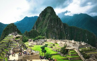
The route connection becomes clearer as the trek approaches Machu Picchu. Hikers shift from long-distance route awareness to detailed site orientation within the citadel when navigation transitions to a Machu Picchu map. The progression shows how the Inca Trail functions as both a structured hiking route and a ceremonial approach to Machu Picchu, meeting search intent by defining purpose, value, and geographic flow of an Inca Trail Tour.

What are the Maps and Routes for Inca Trail Treks?
The maps and routes for Inca Trail treks include the Short Inca Trail
map and route, the Inca Trail 4 Days map and route, the Private Inca
Trail map and route, and the Luxury Inca Trail map and route. Maps and
routes for Inca Trail treks provide a structured overview of how each
trekking option leads toward Machu Picchu while highlighting differences
in distance, duration, and terrain. The maps illustrate official
starting points, daily trail progression, elevation changes, campsites,
and archaeological sites along the route. Route visualization helps
trekkers understand how the Short Inca Trail, Classic Inca Trail,
Private Inca Trail, and Luxury Inca Trail follow regulated paths within
the same protected network while offering varied experiences. Travelers
gain clear insight into trail flow, physical demands, and logistical
structure before selecting the Inca Trail trek that best matches their
time, comfort level, and hiking goals.
Short Inca Trail Map and Route
The Short Inca Trail map illustrates the journey starting from kilometer 104. Trekkers visit ancient ruins (Chachabamba plus Wiñay Wayna) during the 12-kilometer day hike. Path gradients ascend toward the majestic Sun Gate at an elevation of 2730 meters. Direct permit costs fluctuate [$480 to $650]. Buses descend to Aguas Calientes, providing overnight lodging in the town. Guided tours investigate the stone citadel during morning hours. Travelers experience a rich history found on the legendary Short Inca Trail.

Elevation Profile:

Day 1
Km 104 to Wiñay Wayna
The hike starts at Km 104 along the railway and moves uphill
through cloud forest terrain. The route passes the archaeological
site of Chachabamba before continuing toward Wiñay Wayna, the
largest ruin on the Short Inca Trail. Stone steps, forested
slopes, and valley viewpoints define the day’s terrain above the
Urubamba River corridor.
Sun Gate to Machu Picchu
The route reaches the Sun Gate (Inti Punku) early in the morning,
revealing the first panoramic view of Machu Picchu. The trail
descends into the citadel complex for a guided exploration of
temples, terraces, and ceremonial sectors. The visit concludes
with a bus descent to Aguas Calientes.

Inca Trail 4 Days Map and Route
The Inca Trail 4 Days map outlines the classic trekking route starting at kilometer 82 and ending at the Sun Gate overlooking Machu Picchu. Trekkers follow original stone paths passing archaeological sites (Llactapata, Runkurakay, Sayacmarca, Phuyupatamarca, Wiñay Wayna) across mountain ridges and cloud forest. The route includes steep ascents toward Warmiwañusca Pass, reaching a maximum elevation of 4215 meters. Permit availability remains limited, with regulated access enforced by Peruvian authorities. Direct permit and guided tour costs fluctuate [$650 to $950]. Overnight stays occur at designated campsites along the trail. Guided exploration of the stone citadel occurs during morning hours, completing the legendary four-day Inca Trail experience.
Machu Picchu

Elevation Profile

Day 1
Km 82 to Wayllabamba
The trek begins at Km 82 along the Urubamba River, crossing
agricultural terraces and low-elevation valleys. Gentle ascents
lead past Llactapata ruins before reaching the Wayllabamba
campsite.
Wayllabamba to Pacaymayo
The route ascends steeply toward Warmiwañusca Pass through high
mountain terrain. Stone staircases and exposed slopes define the
most physically demanding day.
Pacaymayo to Llactapata
The trail crosses archaeological complexes (Runkurakay,
Sayacmarca, Phuyupatamarca) before descending into the cloud
forest. Long stone paths and ridge traverses dominate the day.
Sun Gate to Machu Picchu
An early start leads to the Sun Gate (Inti Punku), revealing the
first panoramic view of Machu Picchu. The route descends into the
citadel for a guided visit before transfer to Aguas Calientes.

Private Inca Trail Map and Route
The Private Inca Trail map outlines the same historic alignment as the Classic Inca Trail while reserving the route exclusively for a single trekking group. The trail starts at Kilometer 82 (Piscacucho) and ends at Machu Picchu, entering through Inti Punku (the Sun Gate). The map displays the official path across mountain passes, regulated campsites, major archaeological complexes, and restricted conservation zones under government permit control. A private Inca Trail operation allows a personalized pace, dedicated guide team, and flexible daily timing without shared group schedules.
Machu Picchu

Elevation Profile

Day 1
Km 82 to First Campsite
The hike begins at Km 82 with a steady ascent through valleys,
farmland, and river crossings toward the first designated
campsite.
Campsite to Pacaymayo Valley
The route climbs toward Warmiwañusca (Dead Woman’s Pass), the
highest and most demanding point of the trek, followed by a
descent into the next valley.
Pacaymayo to Wiñay Wayna
The trail crosses high passes and visits key Inca sites
(Sayacmarca, Phuyupatamarca, Wiñay Wayna) along stone paths and
cloud forest sections.
Sun Gate to Machu Picchu
The route reaches Inti Punku at sunrise before descending into
Machu Picchu for a guided tour, completing the trek with increased
privacy and schedule control.
Luxury Inca Trail Map and Route
The Luxury Inca Trail map presents the protected alignment as the Classic Inca Trail while emphasizing upgraded campsites, enhanced support zones, and comfort-focused logistics. The route starts at Kilometer 82 (Piscacucho) and ends at Machu Picchu, entering through Inti Punku (the Sun Gate). The map highlights official trail sections, elevation changes, archaeological complexes, conservation boundaries, and premium camp locations used by licensed luxury operators under government permit regulations. The luxury Inca Trail experience maintains historical integrity while layering higher service standards across the route.
Machu Picchu

Elevation Profile

Day 1
Km 82 to Luxury Campsite
The trek begins at Km 82 with a steady hike through river valleys,
farmland, and low elevation terrain. The day ends at a fully
serviced campsite featuring upgraded dining setups and spacious
sleeping tents.
Campsite to Pacaymayo Valley
The route ascends toward Warmiwañusca (Dead Woman’s Pass), the highest and most demanding point of the trek. A controlled descent follows into the next valley, where comfort-focused camp facilities await.
Pacaymayo to Wiñay Wayna
The trail crosses high ridges and cloud forest, passing major Inca ruins (Sayacmarca, Phuyupatamarca, Wiñay Wayna). Enhanced camp services support recovery after sustained elevation changes.
Sun Gate to Machu Picchu
The route reaches Inti Punku early in the morning for the first view of Machu Picchu. The trek concludes with a guided tour of the citadel before transfer to Aguas Calientes, completing the luxury Inca Trail experience.


0 Comments