Chipicalqui, also known as Chopicalqui or Chopicallqui, is a known mountain situated in the Cordillera Blanca region of the Andes in Peru. It stands tall at 6,354 meters (20,846 feet) above sea level, making it one of the peaks in the Cordillera Blanca range.
This mountain can be found in Yungay Province, Ancash, nestled between two peaks. Huascarán and Contrahierbas. The name “Chopicalqui” is believed to have its roots in the Quechua language, where “Chawpi” signifies “center” and “kallki” means “ravine”.
The first successful ascent of Chipicalqui was achieved on August 3, 1932, by a group of climbers, including H. Hoerlin, E. Schneider, P. Borchers, and E. Hein. The used climbing route to reach its summit is via the Southwest Ridge, which involves a snow climb and enjoys popularity among climbers. However, reaching the summit slopes can be challenging due to snow which often presents difficulties for those attempting this route [5]. Other established climbing routes include the Southeast Ridge (alpine grade TD ) and the East Face Direct (alpine grade TD).
Chipicalqui Mountain is known for its peaks and glaciers in the Cordillera Blanca range. Its location, near Huascarán, the peak, adds to its appeal for mountaineers and adventurers seeking thrilling climbs in the Andes.
In terms of its importance to Peru’s economy, Chipicalqui plays a role in the country’s tourism industry. The region surrounding the Cordillera Blanca, including Chipicalqui itself, attracts a number of tourists each year who come to explore its beauty and partake in mountain-related activities like trekking and climbing. This influx of visitors serves as a source of income for communities, businesses and contributes to tourism sector growth in Peru.
While specific data on the number of tourists visiting Chipicalqui annually is not provided, it can be safely assumed that due to its popularity as a climbing destination and proximity to renowned peaks in the area, it receives a considerable amount of visitors.
In conclusion, Chipicalqui stands out as a mountain located within the Perus Andean Cordillera Blanca range. With its elevation and challenging climbing routes, it attracts mountaineers worldwide. Its impact on the economy through tourism, further solidifies its significance within the region.
What is the Chopicalqui History?
The lofty peak of Chopicalqui pierces the heavens, situated in Peru’s Cordillera Blanca. A storied history envelops the mountain, both concerning the ancient forces that shaped its form and the native inhabitants who hold its name in reverence.
The towering peaks and expansive ice fields of the Cordillera Blanca were sculpted gradually over vast expanses of time through the grinding of tectonic forces and the carving of glaciers. This Peruvian sierra is renowned for its arresting summits and ice flows, counted among the loftiest and most sweeping found anywhere.
Historically, Chopicalqui has remained a pivotal location for the native Quechuan inhabitants over many generations. The peak derives its name from an old Quechuan term signifying “the lake’s dwelling”. Local folklore depicts Chopicalqui as the abode of deities and the fountainhead for the surrounding territory’s water resources.
In the infancy of the 1900s, the peak of Chopicalqui transformed into a coveted goal for alpinists and trailblazers. In 1932, a collection of Helvetian mountaineers accomplished the premier victorious climb of the summit. From that point onward, Chopicalqui has developed into a favored terminus for alpinists hailing from the four corners of the globe, proffering taxing ascents and breathtaking vistas of the encompassing scenery.
The peaks of Chopicalqui and the Blanca mountain range are prized as meaningful natural and historical sites in Peru. The locale houses many plants and creatures and provides water and other necessities for nearby towns. Work is being done to save the region’s natural and cultural legacy while furthering accountable travel and supportable progress.
What does Chopicalqui Mean?
The title “Chopicalqui” comes from the native tongue of the Andes, Quechua. The name’s origins are ambiguous, with various explanations according to different references.
A way to comprehend this is that in Quechua, “chopi” signifies “vulture” and “calqui” signifies “snowy summit”, so Chopicalqui could signify “the snowy summit of vultures”. A different analysis is that “chopi” signifies “tooth” and “calqui” signifies “white” or “salt”, thus, Chopicalqui could signify “tooth of white salt”.
Disregarding the precise significance, the appellation Chopicalqui mirrors the autochthonous lineage and civilization of the cordillera locality wherein the peak is situated.
When did Chopicalqui get its name?
The peak, as with countless summits amid the Andes, held a title from the native tongue Quechua in antiquity. Yet the premier account of the massif by an outsider was from the Teutonic trailblazer and geographer Augusto R. Bernardino Leguía in 1897.
The provenance and significance of the appellation “Chopicalqui” remain ambiguous, with discrepant explications contingent on the provenience. Certain conjectures intimate it denotes “molar of blanched sodium chloride” in Quechua, while antithetical interpretations construe it as “niveous apex of the vultures” or “mount of the coruscating asterism.”
“Notwithstanding the precise significance, the term mirrors the native history and customs of the mountain range where the peak is situated. There is a chance the designation was swayed or reworked by Iberian settlers, who routinely altered or forced their names onto nearby geographic characteristics over the time of subjugation.”
What are the theories about the origin of the Chopicalqui?
The towering Chopicalqui is positioned amid the pristine Cordillera Blanca mountains, hewn over epochs through seismic shifts and firestorms of magma in the Peruvian Andes. Various hypotheses swirl regarding the peak’s precise provenance:
Glaciers of old supposedly chiseled Chopicalqui, akin to neighboring Andean summits, into being. As frozen rivers crept, they scraped away encircling stone, forging sheer-sided vales and spires.
The hill was constructed via fiery outpourings in a previous era. The pale mountains are renowned for summits birthed by molten rock, and it’s plausible the hill arose through sequential spewings that heaped layers of cinders and molten stone over time.
The landmass rose: Another hypothesis is that Chopicalqui ascended due to shifts in the plates underneath. When the plates crashed into each other, the outer layer was pushed together and lifted, forming the Andes Mountains.
Though prevailing hypotheses point to the mountain’s inception via diverse means across vast expanses of time, Chopicalqui was probably birthed through a medley of events.
What are the myths about Chopicalqui?
No fables or tales, particularly about Chopicalqui, exist. However, the peak and nearby expanse of the Cordillera Blanca in the Andes of Peru have constituted an integral component of the native civilization and lore for ages.
The native inhabitants of the Peruvian highlands, like the Quechua, tell stories and myths that regularly include the natural parts of the scenery, such as peaks, streams, and dales. These tales and fables regularly mirror the religious convictions and philosophy of the groups that have lived there for ages.
The mountainous regions believe in the “apu,” referring to the divine essence or god linked with a particular peak. Each apu allegedly has its distinct temperament and attributes and is frequently viewed as a guardian and benefactor for those inhabiting the vicinity.
The Incan populace harbors profound reverence for the elemental realm and its might, embedding this devotion within their religious convictions and sacraments. As an illustration, the annual Inti Raymi revelry, commemorating the winter solstice and the sun’s revival, encompasses oblations to the apus and other elemental components as a method of demonstrating gratitude and deference.
The peak and its environs comprise a fundamental component of the abundant ancestral heritage and tales of those indigenous to the Andes.
Is Chopicalqui Important for Peru’s History?
Although the peak of Chopicalqui bears little importance to Peru’s past, the Cordillera Blanca chain holds great significance for Peru’s legacy and environment.
The vicinity houses numerous noteworthy ancient sites and pre-Hispanic societies, encompassing the Chavin, Recuay, Wari, and Inca civilizations, who bequeathed striking architectural and artistic inheritances that continue to be scrutinized and extolled.
The Andes mountain range possesses peaks of Chopicalqui allure to travelers and nature enthusiasts globally. Furthermore, the Cordillera Blanca is reputed due to its wondrous natural magnificence, encompassing ice masses, pools, and elevations.
The locale is relevant its natural and environmental import, housing distinct biological communities and kinds, amongst them the spectacled bear, the Andean vulture, and andous orchid and bromeliad species.
On the whole, despite Chopicalqui lacking direct historical relevance, it constitutes a portion of a broader area significant for its cultural, natural, and ecological importance to Peru and globally.
")
Where is Chopicalqui Located?
Chopicalqui, a peak nestled in the White Mountains, is nestled within the Andean highlands of Peru. The White Mountains form but a small chain in the expansive Andes, a colossal mountain range traversing much of South America.
The towering peaks of the Cordillera Blanca are nestled within the Ancash province of central Peru, spanning some 400 kilometers northwards from the bustling capital city of Lima. Among these lofty summits is Chopicalqui, poised regally amid its towering neighbors such as the unrivaled Huascarán, Peru’s tallest peak.
What are the coordinates of Chopicalqui?
The precise location of Chopicalqui is around 9.1304 degrees southern latitude and 77.6134 degrees western longitude. One can reach the mountain from neighboring municipalities, such as Huaraz, Carhuaz, and Yungay, which act as favored points of departure for sightseers who discover the area’s scenic splendor and historical legacy.
How did Chopicalqui become well-known?
Chopicalqui gained renown chiefly by its stature as an arduous and coveted summit for climbers and thrill-seekers.
In the early 1900s, when mountain climbing became popular with more people in Europe and North America, adventurers started looking at the Andes mountains of South America, like the Cordillera Blanca in Peru. Chopicalqui, with its sheer and rugged land, fast became a goal for daring climbers wanting a fresh test.
The maiden voyage to ascend Chopicalqui was embarked upon in 1932 under the guidance of German Willy Merklexpedition. Despite adverse atmospheric conditions compelling their retreat, the endeavor helped establish Chopicalqui as an arduous and formidable summit.
In 1951, a group of mountaineers from France headed by Lionel Terray were victorious in ascending Chopicalqui for the initial time, solidifying the hill’s status as an arduous and intimidating summit. Numerous squadrons have conquered the mountain through various paths, transforming into a distinguished and esteemed peak within the global alpine community.
Currently, the towering peak of Chopicalqui remains an allure for thrill-seekers and wanderers hailing from all corners of the globe, enticed by the harmonious blend of its arduous ascension, breathtaking splendor, and vibrant history.
What species can be found in Chopicalqui?
The towering peak of Chopicalqui lacks a particular habitat, so no singular or secluded organisms inhabit the area. Nevertheless, the expansive Cordillera Blanca range, amid which Chopicalqui stands, fosters a vibrant array of plant and animal life not found elsewhere.
The towering peaks of the Cordillera Blanca constitute a segment of the expansive Andes, an area recognized globally for abundant life in numerous forms. Various distinctive biomes inhabit the locale, spanning lofty prairies of puna grasses, mist-shrouded woodlands of condensed vapor, and soggy lowlands awash with still waters.
Several distinctive creatures inhabit the Cordillera Blanca area, like the Puya raimondii, the biggest bromeliad on the planet, the Andean bear, the Andean condor, the vicuña, and the spectacled bear. Numerous orchids and other plants suited to great heights also grow here.
The locale is crucial for its freshwater assets, encompassing various waterways and basins that harbor an assorted collection of fish breeds, amongst which is the endemic trout recognized as the Huayhuash trout.
In totality, the expansive Cordillera Blanca region, including Chopicalqui, constitutes a vital territory for the proliferation of life and safeguarding of nature within Peru and globally.
How is the Map of Chopicalqui Layout?

How is the Geography of Chopicalqui?
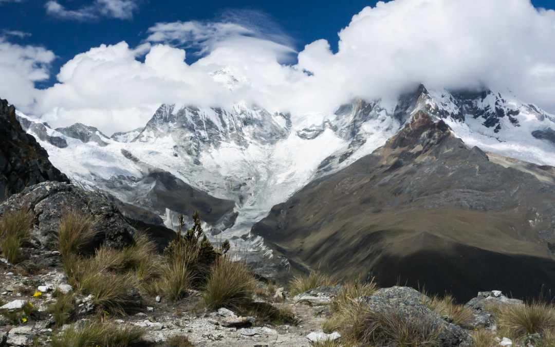
The hefty elevation of Chopicalqui can be found amid the pale peaks of the Peruvian Andes. Though surrounded by jagged land and glaciers inclined at precarious angles, the geography of Chopicalqui is delineated by its lofty position within a mountain band at inhospitable altitudes.”
The towering mount is a craggy summit ascending skyward to a loftiness of 6,354 meters over the waves. The apex is an element of the Huandoy-Chopicalqui assemblage, encompassing diverse other eminent elevations, encompassing Huandoy, Pisco, and Yanapaccha.
The inclines of Chopicalqui boast precipitous crests and profound gullies sculpted by slow ice flows and deterioration over vast expanses of time. The peak is engirdled by multiple mammoth frozen rivers, encompassing the Chopicalqui floe, which meanders down from the crown and signifies a crucial wellspring of the locality’s aqua.
The lofty peaks of the Cordillera Blanca, home to Chopicalqui, boast an array of picturesque vistas with ice-fed lakes and streams meandering amid the landscape. Various natural communities—puna, elfin woodlands, and marshlands—coexist at differing elevations.
The landscape of Chopicalqui is shaped by its position amid lofty peaks, depicted by craggy landforms, steep inclines, and ice fields. It constitutes a vital component of the innate and civilizational legacy of Peru.
What is the Geological Profile of Chopicalqui?
The towering Chopicalqui stands proudly in Peru’s Andean Cordillera Blanca range. Its jagged peak belies the intricate blend of stones and frameworks beneath, forged through eons of clashing plates and natural upheaval.
The peak consists mainly of sedimentary and igneous stones, encompassing sandstones, mudstones, andesites, and dacites. These rocks came into being through diverse mechanisms, comprising the accumulation of sediment, volcanic bursts, and the infusion of molten rock.
The stones comprising Chopicalqui and the neighboring white mountain range have endured immense turmoil and upheaval, evidencing a tangled geological past of elevation construction and tectonic movement. The rocks have suffered from intense compression and searing heat, transforming and altering them into various rock types.
The peak possesses distinct icy forms and white expanses, yielded through the locality’s immense elevations and frigid climes. The frozen rivers and snowy plains have gradually descended the summit over numerous millennia, etching valleys and contouring the terrain.
“All told, the layout of Chopicalqui and neighboring White Mountains comprises an intricate fusion of varied stones and shapes, molded over eons by shifts in the earth and rock.”
What are the Hiking Routes near Chopicalqui?
The peaks near Chopicalqui offer various paths for the venturesome. A few of the frequented trails comprise:
The Santa Cruz trek winds through the Cordillera Blanca’s core for four suns, gliding past frigid lakes and breathtaking peaks. Embarking and concluding in Cashapampa, the path scales Punta Union where Taulliraju, Alpamayo, and Artesonraju dazzle under boundless skies.
The high mountain range Huayhuash provides a demanding 8 to 12 sunrise excursion transporting explorers through its craggy summits and dales neighboring the Cordillera Blanca to the north. Spectacular panoramas of multiple lofty pinnacles are offered, encompassing Yerupaja, Siula Grande, and Jirishanca.
The winding trail navigates through the Llanganuco valley for five sunrises, escorting explorers by several frozen lakes and majestic mountain vistas. Commencing and concluding in the settlement of Huaraz, the path climbs to Punta Union, a summit tendering wondrous sights of numerous lofty peaks, such as Huascaran, Chopicalqui, and Huandoy.
The verdant Ishinca Valley provides a multi-day journey for those desiring to wander amid natural splendor. Commencing and concluding in the settlement of Huaraz, this trek navigates wanderers through numerous bodies of melted ice and awe-inspiring vistas of elevations and dales. The trail ascends to the encampment below the pinnacle of Ishinca, unveiling breathtaking panoramas of the encompassing summits and vales.
The mountainous zone proximate to Chopicalqui in the Cordillera Blanca provides diverse tracks for perambulation and lengthy excursions for nature lovers of all adeptness, spanning straightforward one-day rambles to taxing multi-day treks.
When is the best time to visit Chopicalqui?
The optimal season to explore Chopicalqui and neighboring white mountain range is contingent on your pursuits and intended enterprises. If ascending frosty peaks are your objective, the dry period spanning April through October is ideal. Should you aspire to tackle the Santa Cruz trek, May through September sees sparse precipitation and swarming crowds. For those desiring to kayak turquoise rivers or lounge lakeside, December through March’s rainy season boasts swollen waterways and absent throngs. Whatever your wants, this slice of the Andes obliges year-round.
The arid months, spanning May through September, are broadly viewed as the optimal time to traverse the locale for alpinism and trekking, as the skies are characteristically transparent and rainless, with sparser cloud cover and a smaller possibility of showers. Throughout this period, the temperatures are chillier, especially at loftier elevations, so it is imperative to pack thermal attire and equipment.
The months spanning October to April frequently deliver substantial precipitation and frozen crystals to these lands, complicating the ascents and wanderings while amplifying the perils. Yet for those seeking to witness the picturesque plants and creatures inhabiting this realm, this season can prove reasonable, as the downpours restore vibrancy and foliage to the vistas.
The region experiences an influx of mountaineers and sightseers, specifically in July and August. Therefore, reserving lodging and authorizations ahead of schedule is imperative to explore the locale during the peak of the high season.
Overall, the prime period to voyage to Chopicalqui and the Cordillera Blanca locality relies upon your pursuits, the undertakings you plan to accomplish, and your patience for crowds and climatic states.
Where to stay in Chopicalqui?
“Chopicalqui is a high protuberance hiding in the lonely hills of the Andes in Peru, and voyagers will not discover any lodging spots straight on the mount itself. Those who desire to wander the expanse can make camp in a few settlements and hamlets scattered around the area
The central hub and entrance to the pale peaks is Huaraz. Lodging choices exist in Huaraz, spanning inns, bunkhouses, and lodges catering to an array of means and wants.
Additional nearby settlements that provide lodging alternatives encompass Carhuaz, Yungay, and Caraz, each within a handful of hours of travel from Chopicalqui, proffering an array of housing selections.
Those seeking a more engaging experience can find several mountaineering and ascending organizations in the vicinity proffering escorted explorations and encampment journeys, which could provide shelter lodgings and fundamental comforts along the route.
")
What are the Tours for Chopicalqui?
The mountainous territory of Chopicalqui and its neighboring Cordillera Blanca vicinity proffers sundry expeditions and undertakings pursuant to one’s penchants and proficiency. A number of the prevalent jaunts and deeds embrace:
Ascending the summits: Supervised campaigns for the practiced peak scalers remain to overcome Chopicalqui and additional apexes inside the Ivory Mountain Range. These pursuits commonly hold a reinforcement squad, apparatus leasing, and housing inside alpine shelters.
Exploring Expeditions: Numerous chaperoned traversing undertakings are accessible in the Cordillera Blanca, extending from sunlight strolls to numerous day travels through the mountains. A few of the prevalent moving ways incorporate the Santa Cruz campaign, the Huayhuash campaign, and the Llanganuco campaign.
Cultural Journeys: Varied expeditions subsist inside the vicinity, allowing travelers to learn about the native societies and chronicles of the mountain range. These travels could hold going to provincial populaces, archaeological locales, and galleries.
The Cordillera Blanca attracts many thrill-seekers for its exciting escapades. Mountain bikes traverse the rocky landscape, whitewater rafts plunge down frothy rivers, and paragliders soar on the Andean thermals. For visitors craving an adrenaline rush, outfitters eagerly provide the necessary gear and guidance to partake in these escapades amid the peaks.
The mountain range harbors an abundance of plants and animals, with many excursions on offer for those keen to witness the pristine splendor and critters inhabiting the locale. Options include avian observation, beast detection, and trips to natural wonders like icy rivers and pools.
In totality, a plethora of explorations and undertakings are on offer for sightseers to Chopicalqui and the Cordillera Blanca domain, spanning from alpine missions to ethnological jaunts and thrill-seeking sports. Critical is selecting an exploration corresponding to your concerns and competence and reserving ahead to guarantee accessibility.
What are the Closest Destinations to Chopicalqui?
Huaraz holds an allure, with its towering mountains known as the Cordillera Blanca range. It is the gateway to these majestic peaks, conveniently located 50 kilometers from the majestic summit of Chopical. Huaraz is renowned for its captivating architecture serves as a starting point for thrilling mountain explorations.
Nestled 30 kilometers from Chopicalqui lies the picturesque Llanganuco Valley. This enchanting valley boasts two lakes, Llanganuco and Chinancocha, adorned with mesmerizing turquoise waters originating from the glaciers within the mountains.
In proximity lies Huascaran National Park, a destination showcasing a multitude of renowned mountains, including Peru’s highest peak. Huascaran. The park is celebrated for its mountain vistas, icy glaciers, unique flora, and fauna that thrive in high-altitude environments.
Around 50 miles from Chopicalqui stands Chavin de Huantar, a place of worship steeped in history. This remarkable site showcases temples and structures constructed by the Chavin people, who inhabited the area centuries ago, predating the common era.
The Cordillera Blanca region offers captivating destinations to explore beyond the Chopicalquis realm. In Huaraz or the Cordillera Blanca, you’ll find towns, breathtaking valleys, protected wildlife areas, and captivating ancient sites waiting to be explored. It’s an opportunity to immerse yourself in the beauty of the mountains and delve into their history.
How to Get from Lima to Chopicalqui?
To travel from Lima to Chopicalqui, there is a distance between them 300 leagues or 292 miles. However, no need to fret as there are ways to reach your destination!
The convenient and efficient method is by taking a flight. You can board a plane from Lima to Huaraz, which serves as the access point to the White Mountain Range. Once you arrive in Huaraz, you can arrange transportation to Chopicalqui.
Buses are available for the journey from Lima to Huaraz if you prefer transportation. The bus is typically around 8 to 10 hours. It allows you to relish the beauty en route. Upon reaching Huaraz, you can organize a ride toward Chopicalqui.
Alternatively, you can drive your vehicle from Lima to Chopicalqui. Depending on traffic and road conditions, this expedition usually takes about 8 to 10 hours. You will traverse through deserts before ascending to the heights of the Andes mountains.
It’s worth noting that flying is the means of reaching Chopicalqui, followed by taking a bus. It’s advisable to book your transportation in advance during peak seasons when demand’s high. Additionally, before embarking on any mountaineering or trekking adventures in the region, ensure that you acclimate yourself properly to the altitudes of the Andes mountain range.
If you ever decide to visit Huaraz or the Cordillera Blanca, you’re in for a time discovering the mountains and delving into their captivating history!
What to know before going Chopicalqui?
Here is a list of what to know before going to Chipicalqui;
Staying Fit; Climbing Chopicalqui is quite an endeavor, so it’s essential to maintain good physical fitness. Exercise and train specifically for the challenges of high-altitude conditions before you climb.
Getting Used to Altitude; The mountain’s significant elevation can bring about altitude sickness, which can be perilous. To acclimatize yourself properly, spend a day in Huaraz or nearby areas before you begin your ascent.
Seek Expert Guidance; If you’re not a climber, it’s advisable to only attempt to climb Chopicalqui with others. Hiring a guide or joining an expedition team familiar with mountain routes and challenges is crucial.
Essential Gear and Equipment; Make sure you have all the gear for mountaineering, including clothing, sturdy boots, crampons, ice axes, ropes, and a helmet. Check that your equipment is in condition and suitable for high altitude conditions.
Unpredictable Weather; The weather in the Andes can be erratic and severe at altitudes. Stay updated with weather forecasts. Be prepared for changes in conditions.
Permits and Regulations; Consult authorities regarding any permits required for climbing Chopicalqui. Show respect towards the mountain environment by adhering to Leave No Trace principles that help minimize your impact on nature.
How is the Chopicalqui Itinerary?
Below is the best itinerary for climbing Chipicalqui:
Day 1;
Begin your journey from the United States to Lima, Peru. Most flights arrive in Lima during the evening. Once you land, take a taxi to our hotel in Lima.
Day 2;
We depart from Lima. Embark on a scenic drive to Huaraz, the gateway to the Cordillera Blanca. This will take up most of the day. Unwind at our hotel.
Day 3;
Today in Huaraz, we spend time acclimatizing by embarking on a half-day hike to Churup Lake at 14,400 feet. Later in the afternoon, we review the equipment for our mountain climb and prepare our packs for departure the following day. Overnight stay in Huaraz.
Day 4;
We start our day by leaving Huaraz in the morning and driving two hours to Cebollapampa at an elevation of 12,800 feet. Here amidst breathtaking scenery and surrounded by peaks of the range, we set up camp in a meadow. In the afternoon, we embark on a hik, to Lake 69 at an elevation of 15,250 feet—a lagoon nestled beneath Nevado Pisco and Chacraraju.
Day 5;
Taking advantage of base ccampamenities and allowing our bodies ample time to adjust and rest before undertaking altitudes is how we spend this day at BC (base camp). Additionally, we. Prepare all gear that will be carried up to our higher centers.
Day 6
As we bid farewell to our cook and the comforts of Base Camp, we make our way to Camp 1. This camp is situated at the edge of the glacier. We reach it by walking on smooth granite slabs worn down by the retreating glacier.
Day 7
Today marks our attempt to summit Yanapaccha standing at 17,716 feet. It involves a climb up the glacier, taking us to the slopes. From there, we face two sections of snow and ice that grant us access to Yanapacchas summit. After enjoying the breathtaking views from the top, we retrace our steps back to Camp 1, where we spend the night for acclimatization.
Day 8
In the morning, we descend from our climb. Return to Base Camp at Cebollapampa. The rest of the day is devoted to rest and savoring our deserved achievement of conquering the Cordillera Blancas summit.
Day 9
Today is dedicated to rest as we prepare for our journey up to Chopicalqui Camp 1. We take advantage of this time to rejuvenate ourselves while making arrangements for the stage of our expedition.
Day 10
As we make our way towards Chopicalqui Moraine Camp, situated at an altitude of 16,075 feet, towering Huascaran peaks dominate the surrounding vistas—similarly captivating as it was during our hike towards Yanapaccha Camp 1. We navigate through terrain trails until reaching the moraine, where we establish camp.
Day 11
On the day, we rise early at Chopicalqui Camp 2 (17,716 feet). Prepare to move up to High Camp. As we enter the glacier, our path will take us on a route navigating around crevasses on this side of the mountain. We’ll encounter ramps with up to 40 degrees gradients during our climb.
Day 12
Summit day at Chopicalqui (20,846 feet) begins from our camp. We follow the southwest ridge towards the summit encountering pitches along the way. The views from the top are truly unmatched. While this is undoubtedly the demanding day of our journey, the breathtaking scenery and sense of accomplishment make it all worthwhile. After reaching the summit, we return to Camp 1 for a stay by rappelling down the sections we ascended.
Day 13
Today is dedicated to descending to Huaraz (10,000 feet). We wake up again and pack up our camp before going to Base Camp. Our cook will welcome us with a deserved brunch upon arrival. After dismantling our tents and loading everything onto buses, we return to Huaraz.
Day 14
This day is a contingency or backup in case unforeseen circumstances require time.
Day 15
Following breakfast, we load up into a vehicle. Commence our drive back to Lima.
On Day 16 of our trip, we reach Lima in the afternoon. Make our way to the airport to catch our evening flights back home. It’s a travel day as we finally arrive at our destination. Day 4 5; Getting Ready for the Climb
We take some time to adjust and rest in Cebollapampa before going to the mountain base camp of Yanapaccha. We practice climbing techniques. Ensure equipment is organized adequately for when we attempt to reach the summit.
Day 6 7; Scaling Yanapaccha
We embark on the ascent of Yanapaccha, a challenging glacier climb. Eventually, we conquer its summit. Are rewarded with panoramic views. To further acclimatize ourselves, we spend the night at Camp 1.
Day 8; Returning to Base Camp
We descend to Base Camp and celebrate our successful summit!
Day 9; Preparing for Chopicalqui
We take some time off to rest and mentally and physically prepare for our next exciting challenge. Chopicalqui.
Day 10 11; Camping on Chopicalqui
Our journey continues as we hike towards Chopicalquis Moraine Camp and reach Camp 2. Along the way, we find ourselves surrounded by the peaks of Huascaran.
Day 12; Conquering Chopicalquis Summit
Today is a day as we tackle the slopes and crevasses on our way up to Chopicalquis summit. The view from above is nothing of awe-inspiring, making all our hard work truly worthwhile.
Day 13; Returning to Huaraz
After descending from the summit, we gather our belongings. Make our way back to Huaraz. There we treat ourselves to brunch as well-deserved relaxation awaits us.
Day 14; An DayWe always make sure to have a day in our itinerary in case anything unexpected happens or we stumble upon new exciting experiences.
Day 15; Heading back to Lima
We begin our journey to Lima. Catch our flights home in the evening.
Day 16; Returning Home
After a fulfilling trip, we finally arrived home!
How much does it cost to visit Chopicalqui?
The trip cost will depend on factors, including the duration of your stay and the level of service you provide. The timing of your visit. Let’s break it down;
Accommodation;
If you choose to stay in a hostel dorm bed, expect to pay around $50 per night. Opting for a room will cost $100 per night.
Food;
Suppose you decide to cook your meals budget around $20 per day. If you prefer eating out, expect to spend around $30 per day.
Guide;
For those planning to climb Chopicalqui hiring a guide for a five-day trip will cost about $500.
Porters;
If you need assistance carrying your gear during the five-day trip, budget around $200 for porters services.
Transportation;
Flying to Huaraz and taking a bus to the trailhead is estimated at $500 for round-trip transportation.
Personal Gear;
You’ll need items like a sleeping bag, tent, mountaineering boots, etc. which can add up to $500.
For a 5-day trip, your expenses can range from $1,000 to $2,000. Remember that it’s also crucial to have travel insurance in case any unexpected situations arise during your journey.
And here’s an exciting tidbit; The experience of climbing Chopicalqui is truly priceless! With breathtaking views waiting at the top, it’s an adventure for every penny spent. Make sure you’re ready physically for the challenge. You’ll have an adventure! Also, before heading out, check the travel advisories and entry requirements with the U.S. Department of State. Remember to ensure your passport remains valid for at least six months after your return date.
How long should someone plan to stay in Chopicalqui?
Typically it takes around five days to climb Chopicalqui. However, it’s essential to remember that this timeline can vary depending on your fitness level and experience. Some individuals may prefer less time on the mountain, so it’s necessary to tailor your plans according to your abilities and comfort.
Which is the nearest city to Chopicalqui?
The closest city to Chopicalqui is Huaraz, a destination in Peru renowned for its trekking adventures. You’ll find tour operators in Huaraz who can assist you with your trip to Chopicalqui.
Who are some climbers who have successfully conquered Chopicalqui?
Several remarkable climbers have achieved the feat of Chopicalqui;
Germán Gamarra; holds the distinction of being the person to reach the summit of Chopicalqui back in 1936. Bravo, Germán!
John Roskelley; An mountaineer who accomplished reaching the top of Chopicalqui without using oxygen in 1972.
Ed Viesturs; This extraordinary American mountaineer has conquered all fourteen of the world’s 8,000-meter peaks, including Chopicalqui. Truly inspiring!
How is Chopicalqui being protected?
Safeguarding Chopicalqui is crucial not for the local community but also for climbers worldwide. The mountain boasts breathtaking glaciers we must work diligently to protect from melting. Here are a few ways we can contribute to the protection of Chopicalqui;
- We can manage the number of climbers on the mountain, ensuring it is manageable.
- Educating climbers about the significance of taking care and preserving the beauty of Chopicalqui.
- Supporting organizations dedicated to safeguarding Chopicalqui as they are doing work!
Is Chopicalqui recognized as a UNESCO World Heritage Site?
Currently, Chopicalqui has not been designated as a UNESCO World Heritage Site. However, efforts are being made by groups to have it listed as one.
Is there any risk to Chopicalqui?
Unfortunately, Chopicalqui is facing some threats due to climate change. The glaciers are melting, which poses a risk to the stability of the mountain.
Rest assured; there are measures we can take to assist;
- Reducing greenhouse gas emissions, such as minimizing our reliance on fuels.
- Safeguarding the glaciers on Chopicalqui so that they remain cool.
- Educating everyone about climate change. How each individual can contribute towards mitigating its effects.

Miguel is a professional tour guide from Cusco, Peru, with almost 20 years of experience leading tours and a deep knowledge of Peru’s cultural and ecological diversity. He is also an advocate of ecotourism and cultural sensitivity and has lectured on these topics in the US and Europe. He co-founded Evolution Treks Peru, a worker-owned travel company based in Cusco.


