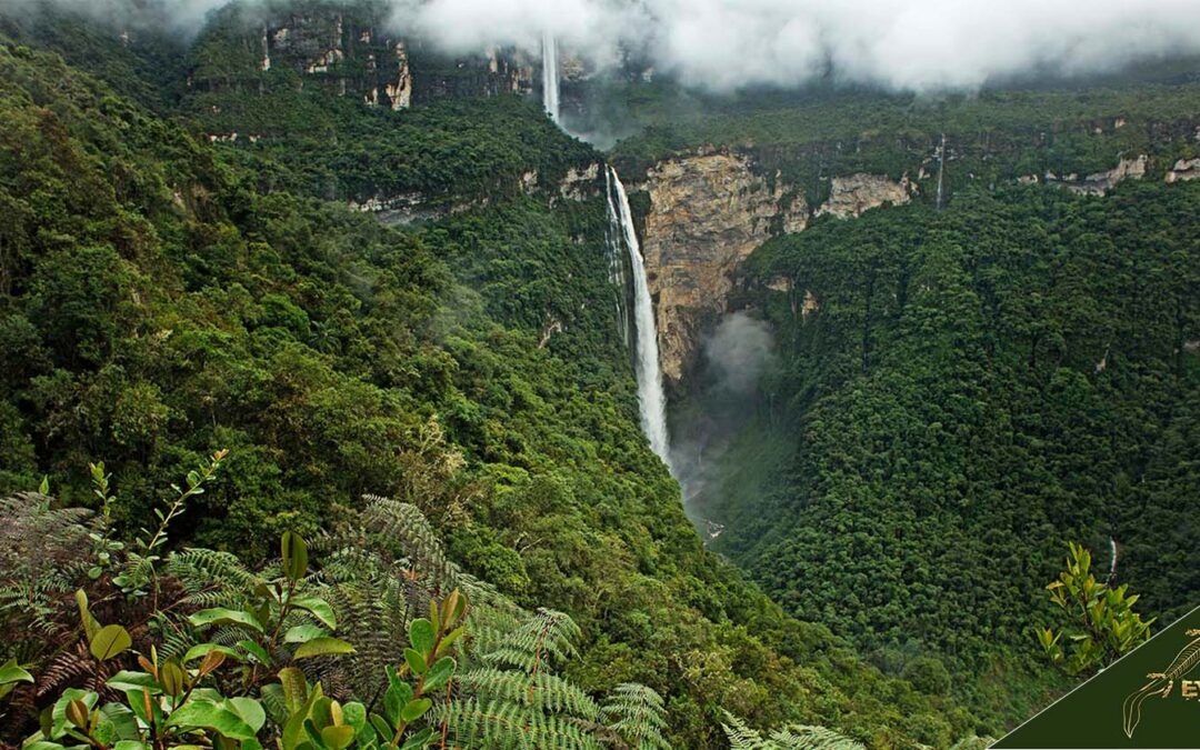
es Gocta is a waterfall located in the province of Bongara, department of Amazonas. It is a must-see destination for hiking, trekking, and archeology lovers.
It currently ranks 17th in the world ranking of waterfalls, with a height of 771 meters.
It is also the third highest waterfall in Peru, behind the 914 meter ‘Tres Hermanas’ waterfall located in the Junin region and the Yumbilla waterfall in the Amazon region which is 896 meter high.
The surrounding valley is an area of abundant jungle, and home to 22 more waterfalls. Gocta is located in northeastern Peru, in the district of Valera, province of Bongará in the Peruvian Amazon region.
The region’s capital, Chachapoyas, is 50 km from the waterfall. The closest places from where you can access Gocta are the villages of San Pablo and Cocachimba.
The origin of the term Gocta refers to several legends: On the one hand, it is linked to the sound emitted by the yellow-tailed choro monkey that lives near the waterfall.
Others speak of the term’s similarity with the sound of the drops falling and colliding with the stones that make up the walls of the path to the waterfall.
Several routes can be taken to reach the Gocta waterfall.
The nearest route commences from the city of Chachapoyas, while the alternative route initiates in Jaen, Cajamarca, leading to the quaint village of Cocachimba. This village offers essential services, including dining and accommodations. Visitors can embark on a scenic two-and-a-half-hour trek from Cocachimba to Gocta on foot, or opt for a horseback journey.
The second option goes through the town of San Pablo, from where visitors take a scenic hile filled with endemic flora and fauna such as hummingbirds and the exotic cock of the rock.
The Gocta waterfall route is part of Peru’s northern tourist circuit which includes the pre-Hispanic fortress of Kuelap, the Sarcophagi of Karajía, the mausoleums of Revash, the Inca trail in Amazonas, the cavern of Quiocta, among many other archaeological and natural attractions.
A legend states that in Gocta dwells a mermaid who was the victim of a curse, so she had to stay in the waterfall assisting a snake while both guarded a pot of gold.
Another legend commonly spread by travelers tells that a mermaid used to harass men who, enchanted by her beauty, followed her until they were dragged to the depths of the waterfall.
Some villagers still say that a local man, Juan Mendoza, remains in the rocks behind the waterfall, where he was dragged after an enchantment.
During the high tourist season, approximately 1,000 tourists a day visit the Gocta waterfalls.
The department of Amazonas is the fourth most important tourist destination in Peru thanks to the ruins of Kuelap and the Gocta waterfall.
What is the history of the Gocta Waterfall?
The history of the Gocta Waterfall begins in March 2006 when a group of explorers led by the German Stefan Ziemendorff made topographic measurements of the waterfall and discovered that its total height is 771 meters when its two stages are measured.
Such height turned Gocta into the 17th highest waterfall in the world, and the third highest waterfall in Peru.
Since then, the Gocta waterfall began to be visited by many tourists. During the high season, more than a thousand people a day visit this natures’ wonder.
While it is true that the waterfall was known to the local people, their distance from it and fear of myths about mermaids and enchantments kept them away.
Historically, near the Gocta Waterfall, the Chachapoyas culture developed remarkable military and family architecture and, especially, a complex funerary architecture that indicates the importance that this culture gave to their ancestors and death.
What is the significance of the Gocta waterfall?
The Gocta Waterfall stands as one of the tallest waterfalls in the world and has become an iconic symbol for the region of Chachapoyas.
Aside from its immense size, Gocta has a unique cultural significance for the local people of Chachapoyas and the Peruvian people as a whole.
For instance, the waterfall is believed to be home to Kusi Kamayu, a mystical being that locals revere as a protector and guardian spirit. This belief has historically brought tourists to the area and made it a popular destination for hikers and nature lovers.
The Gocta Waterfall is deeply embedded in Peruvian culture and continues to be revered as a sacred place by locals who live nearby.
According to local lore, Kusi Kamayu lives at the top of Gocta’s highest cascade, granting wishes made by anyone that can make it up there without turning back.
Tourists often come bearing offerings such as food or jewelry to leave at the base of the fall in hopes of earning Kusi Kamayu’s favor.
Therefore, while embarking on your journey towards Gocta, you may very well find yourself joined by other pilgrims offering gifts out of respect for this mythical being that many believe still inhabits these lands today.
Is the Gocta Waterfall important to the history of Peru?
Despite being known by the locals, Gocta has a unique cultural significance for the people of Chachapoyas because of the size of the falls which places it as one of the highest in the world, and its importance for both geography and tourism in the area.
In addition, Gocta is located where the Chachapoyas culture developed and expanded.
Where is the Gocta Waterfall located?
The Gocta Waterfall is located near the Cocachimba town in the province of Bondara of the Amazonas department of Peru. The waterfall flows into the Cocahuayco River and is located northeast of the Golondrinas Waterfall and north of the Utcubamba River. The region’s cloud forest surrounds the nearby landscape.
What are the coordinates of the Gocta waterfall?
The coordinates of Gocta Falls are:
Latitude: -6.0229842446375415
Longitude: -77.8873088887487348
Altitude: 2630 meters

What are the tours to Gocta Waterfall?
Day excursions typically commence from nearby Chachapoyas, offering comprehensive packages inclusive of round-trip transportation, an experienced guide, and an exploration of the captivating Gocta waterfall. Catering ideally to families, seniors, and children, these tours are especially well-suited for those seeking a more accessible experience.
For those without prior hiking experience, opting for a horseback tour is highly recommended. The day tours kick off early, with pick-ups occurring before 7 am from your hotel or designated meeting point in the charming city of Chachapoyas, the regional hub serving as the entry point to archaeological wonders like Leymebamba and Karajia.
The journey unfolds with a scenic one-hour drive through the Utcubamba river valley, culminating in the arrival at Cocachimba village, the starting point for the trek to Gocta waterfall.
Hiking enthusiasts can explore guided hiking tours that navigate through the Amazon rainforest, with itineraries ranging from a single day to multiple days, depending on preferences.
For a more comprehensive experience, some tour operators offer combination tours, incorporating visits to other regional attractions such as the ancient city ruins of Kuelap or the nearby Cocachimba waterfall.
The comprehensive combination tours extend to the majestic Kuelap Fortress. Commencing from Chachapoyas at 8:00 AM, comfortable transportation takes you to the archaeological site of Macro for a stop en route. A cable car ride from Nuevo Tingo to Malca precedes a straightforward 30-minute hike to Kuelap, perched at 3,000 meters above sea level on the Barreta mountain.
Kuelap is a place of intricate architecture where circular buildings were adorned with rhomboidal shapes, and zigzag patterns. After exploration, a seamless transfer takes you back to Chachapoyas.
For those seeking independence, self-guided tours offer an option to reach the waterfall individually. Utilizing buses or hiring a taxi to the trailhead, visitors can embark on a self-paced hike to witness the awe-inspiring Gocta waterfall.
What is the best season to visit the Gocta waterfall?
The best season to visit Gocta Falls is the rainy season, between October and April when we the falls can be seen at their maximum beauty.
Conversely, one can visit the falls between May and September, when there is no rain, and the hiking routes are dry and easy.
However, the chance to enjoy the falls in their greenish splendor is exponentially reduced.
What are the hiking trails to Gocta Waterfall?
-
Route Options:
- From San Pablo to the First Waterfall: Covers a distance of 6 kilometers.
- From Cocachimba to the Second Waterfall: Encompasses a 5.2-kilometer route.
- San Pablo to Cocachimba: A more extensive journey spanning 15 kilometers.
-
Circuit Recommendations:
- Ideal to commence the circuit from San Pablo for proximity to Chachapoyas upon return.
- Offers a complete tour of both the first and second Gocta falls, providing a comprehensive experience.
-
Variants for Flexibility:
- Choose a round trip from Cocachimba to the first waterfall, covering 10 kilometers.
- For those finding the full circuit challenging, consider hiring a horse for a section of the route.
- Horse rentals range from $10 – $12, easing the trek between the first and second falls due to steep terrain.
-
Safety and Considerations:
- Essential to consider physical effort, weather conditions, and safety during the journey.
- Encouraged to witness the breathtaking scenery of the first and second falls and the lush forest along the trail.
-
Currency Note:
- Note that currency exchange rates in Peru fluctuate; currently, the dollar is approximately 3.88 soles.
-
Nearby Trail Options:
- San Pablo – Cataracta del Gocta – Cocachimba. (Hard, 4.9 stars)
- Gocta Waterfall via Valera San Pablo. (Hard, 5.0 stars)
- Cañon del Sonche. (Moderate, 4.5 stars)
- Chachapoyas – Levanto. (Hard, 4.8 stars)
- Sarcófago de Karajía. (Moderate, 3.9 stars)
- Yumbilla Waterfall.
- Chachapoyas – Utcubamba River.
- Chachapoyas – Sonche Canyon.
What are the closest destinations to Gocta Waterfall?
Chachapoyas is the primary gateway to the magnificent Gocta Waterfall. However, San Pablo de Valera and Cocachimba serve as prominent hubs with well-traveled routes leading to the falls. Other important tourist attractions such as the Kuelap ruins and the Karajia sarcophagus are located in the Chachapoyas proximity.
What are the closest destinations to Gocta Waterfall?
ther attractions such as the Kuelap ruins and the Karajia sarcophagus.
To embark on the trail to Gocta, visitors can register at two key checkpoints situated in the welcoming towns of Cocachimba and San Pablo de Valera.
The differentiating factor between the two towns lies in their proximity to each waterfall. San Pablo de Valera grants easy access to the first and highest fall, while Cocachimba provides a gateway to the second fall, renowned for its popularity among tourists, offering a plethora of tours and accommodations.
How to get from Cusco to Gocta Waterfall?
1. Take a flight from Cusco to Jaen, the capital of Amazonas Province in Peru. Depending on the airline you choose, it can take anywhere between 6 to 10 hours, so make sure to plan ahead and book your tickets accordingly. There are no direct flights from Cusco to Chachapoyas, and all flights will have a stopover in Lima.
2. From Jaen, it is a 3 to 4-hour drive by car to Cocachimba, the nearest village to Gocta Waterfall. Check the weather before leaving, as some roads may be inaccessible due to rain and muddy conditions.
3. Once you reach Cocachimba village, several local guides can take you on a 20-minute hike up to the waterfall entrance. It’s essential to wear comfortable shoes for this part of the journey, as there will be plenty of steep steps and uneven terrain.
4. At Gocta Waterfall, you’ll have to pay an admission fee before entering the park area, where you can marvel at its beauty. If you want to take home something from your trip, you will also find several restaurants, cafes, and souvenir stalls.
Finally, you can continue to Chachapoyas and visit the Kuelap fortress.
, The Nasca Lines are a set of giant geoglyphs located in the Peruvian coastal plain, about 400 kilometers south of Lima (the Capital of Peru).
Created by the ancient Nasca culture and depicting plants, animals, and various shapes, the 2,000-year-old Nasca Lines can only be fully appreciated from the air due to their enormous size.
Despite having been studied for more than 80 years, the geoglyphs, declared a World Heritage Site by UNESCO in 1994, are still considered a mystery by researchers.
There are a few theories about the origin of the Nazca Lines; among the main ones, for instance, Maria Reiche was convinced that the lines represented a vast astronomical calendar used to mark the places where the sun and other celestial bodies rose and set on the horizon.
Also, the British explorer Tony Morrison found evidence of the existence of small shrines that appeared to be connected by the Nazca lines.
Others have considered that the lines served as ritual centers to help the dead attain immortality or to perform religious ceremonies and rites.
Moreover, scholars believe that it was a Map of water sources and a form of worship of the water-providing deities: It has been proposed that the lines and shapes served as a map of subway water sources for those who needed supplies in the desert.
Archaeologist John Reinhard also suggested that the figures symbolized the worship of the water-providing deities.
The offer of tours to visit the Nazca Lines is extensive. You have a great variety of options to choose from, such as overflights to the Nazca Lines, the combination of flight + Buggies and Sandboard, and the flight plus a visit to the Cantalloc Aqueducts.
The desert climate in the Nasca area means there are no winters with shallow temperatures. Although the lines can be visited throughout the year, the ideal time to do it is between December and March because the winds and turbulences are minimal in that season.
Also, during this time of the year, the summer is warmer, allowing light and comfortable clothing to be used.
The geography of the province of Nasca is characterized by valleys and rivers (Ingenio – Changuillo, Aja, Socos, Tierras Blancas, Taruga, Trancas, and Poroma rivers), all tributaries of the Grande river basin.
There are immense pampas and hills typical of the coastal desert. To the province’s east, you can appreciate gorges that give beginning to the first Andean foothills.
The place where the Nasca culture developed is a tablazo, a tectonic uplift, which in the case of the tablazo of Ica flows into the sea in the form of a low cliff.
The climate is warm, rainfall is scarce, and the terrain is arid, with sandy pampas and quite porous, with numerous subway filtrations that change the course of the rivers, which on many occasions emerge several kilometers away, constituting oases.
Every year, more than one hundred thousand people visit the Nazca Lines. The lines are essential for the province of Nasca, as they generate employment and a great deal of fluidity in the local economy.
To date, more than 1,500 geoglyphs are known in the Nasca lines.
The geometric lines and figures extend over 400 square kilometers in southern Peru; In some cases the figures are up to 1.9 kilometers long, and the lines are up to 10 kilometers.
What is the history of the Nazca Lines?
The Nazca Lines are a group of geoglyphs made in the Nasca desert in southern Peru. They were created between 500 BC and 500 AD by members of the Nasca civilization.
There are two main phases of the Nazca lines: the Paracas phase, from 400 to 200 BC, and the Nasca phase, from 200 BC to 500 AD. As of this year, 2022 even 168 new figures have been found with drones, and archaeologists believe there are more to be found.
Most lines cross the landscape in a straight line, but there are also symbolic designs of animals and plants. The combined length of all lines exceeds 1,300 km.
The lines are usually between 10 and 15 cm deep. They were made by removing the top layer of reddish-brown iron oxide-coated pebbles to reveal a yellowish-gray subsoil.
When the sub-layer of this gravel is removed, the light-colored clayey soil exposed at the bottom of the trench contrasts sharply in color and tone with the surrounding ground surface, producing visible lines.
This sublayer contains large amounts of lime. With the moisture of the morning fog, it hardens to form a protective layer that shields the lines from the winds, thus preventing erosion.
The Nasca used this technique to “draw” several hundred simple but enormous curvilinear figures of animals and humans.
The earthwork project is vast and complex: the area covered by all the lines is almost 450 km2, and the most prominent animal figures alone can span nearly 370 m.
For instance, the hummingbird is 93 m long, the condor is 134 m, the monkey is 93 m by 58 m, and the spider is 47 m.
The total area of the lines is almost 450 km2, and the giant figures can cover nearly 370 meters.
The Nasca region’s dry, windless, constant climate has preserved the lines well. This desert is one of the driest on Earth and maintains a temperature near 25 °C (77 °F) throughout the year.
The lack of wind has helped keep the lines exposed and visible.
Some of the Nasca lines form figures best seen from the air (at about 500 m), although they are also visible from the surrounding foothills and other high places.
A continuous line usually forms the figures. Due to their isolation and the plateau’s dry, stable, windless climate, the lines have been mostly naturally preserved.
On rare occasions, weather changes may temporarily alter the overall designs. As of 2012, the lines are said to have been deteriorating due to the influx of squatters inhabiting the land.
The figures vary in complexity. Hundreds are simple lines and geometric shapes; more than 70 are zoomorphic designs, such as a hummingbird, spider, fish, condor, heron, monkey, lizard, dog, cat, and human.
Other shapes include trees and flowers.
Scholars differ in their interpretation of the purpose of the designs but generally attribute religious significance to them. They were designated a UNESCO World Heritage Site in 1994.
Several pivotal figures have delved into the mystery of the Nazca Lines since the arrival of the spaniards to the Inca Empire to date.
These include the 16th-century Spanish explorer Pedro Cieza de León who was one of the first ones to have recorded its existence.
More recently the Peruvian scholar Toribio Mejía Xesspe, and the Americans Paul Kosok and John Reinhard (the latter esteemed within National Geographic) did extensive work in the area.
Also, German researcher Maria Reiche who dedicated her entire life to uncover its mysteries, and Japanese scholar Masato Sakai.
We recommend the following books If you wish to learn more about the Nazca Lines, w:
- Contributions to geometry and astronomy in ancient Peru. REICHE, María. Editorial Epígrafe. 1993,
- Nasca Lines. Of the men who drew the desert. HERRAN, Eduardo. Editorial Faculty of Communication Sciences, Tourism, and Psychology of the USMP. 2016.
- The Nazca Lines. A new approach to their origin and meaning. REINHARD, Johan. Editorial Los Pinos. 1997.
To date, more than 1,500 geoglyphs are known in the Nasca lines.
The lines and geoglyphs of Nasca and Pampas de Jumana in Palpa are considered extraordinary examples of the astronomical and religious expression of the pre-Hispanic societies that flourished on the southern coast of Peru.
Thanks to their exceptional surface design, they bear witness to a culture whose tradition, beliefs, and thinking developed independently in South America.
The site was transformed into a highly symbolic, ritual, social and cultural landscape that remains visible today.
The Nazca Lines were declared Historical and Cultural Heritage on December 17, 1994.
The Nazca lines are considered the most outstanding group of geoglyphs in the world and are incomparable in extension, magnitude, quantity, size and diversity with any other similar work in the world.
What are the theories about the origin of the Nazca Lines?
Recent investigations led notably by archaeologist Johan Reinhard, sheds new light on the Nazca Lines’ potential significance.
He argues a different purpose for the Nazca Lines, suggesting a connection to water—a vital asset in the arid Peruvian coastal region.
Contrary to being an irrigation system or a guide for finding water sources, these geoglyphs are thought to have served as part of a ritual aimed at invoking much-needed rain from the gods.
Other scholas such as Maria Reiche, a pioneering Nasca researcher, proposed an idea that the lines constituted a vast astronomical calendar, marking the positions where the sun and celestial bodies rose and set on the horizon.
Maria Reiche dedicated her almost her entire life to the understanding of the Nasca lines and her contributions are inmesurable.
Another theory suggests a religious significance, positing that the lines were crafted to honor the gods. Given the Nasca civilization’s strong religious practices, this dedication to the project aligns with their spiritual beliefs.
British explorer Tony Morrison uncovered small shrines seemingly linked by the Nazca lines. Some speculate that these lines could have functioned as ceremonial sites, aiding in rituals for the departed or religious ceremonies, potentially linked to the pursuit of immortality.
What are the myths about Nazca Lines?
The myths surrounding the Nazca lines encompass extraterrestrial connections and ancient astronaut theories.
These beliefs intertwine with stories of teachers arriving from the sky, depicted within the lines, resembling “flying gods” in Nasca legends from the 16th-century Spanish conquest of Peru.
According to some Nasca myths, these celestial beings possessed elongated skulls, contributing to the prevalent belief that these enigmatic lines were constructed by extraterrestrial visitors.
Swiss writer Erich von Daniken ardently supported the notion of ancient astronauts and extraterrestrial involvement. His 1968 publication, “Chariots of the Gods,” postulated that these mysterious shapes and lines were crafted by ancient beings as navigational aids and landing strips for their spacecraft.
Von Daniken’s assertions suggested that the Nazca lines substantiated the visits of extraterrestrial astronauts, shaping ancient civilizations.
He proposed that the Native Americans, viewing Nasca as a sacred site, continued to create additional figures and tracks, hoping to entice the gods’ return, although they never did.
How were the Nazca Lines formed?
The Nasca Lines, made between 500 BC and 500 AD, were crafted by gently removing dark rocks, revealing lighter ground underneath, forming these famous shapes in the desert soil.
Ancient indigenous Nazca workers used ropes and stakes to make straight lines and marked edges for larger shapes like trapezoids.
They removed stones and arranged them along the borders, creating spirals by moving in circles, gradually widening the lines.
People used simple tools, not high-tech equipment, to form these stunning designs. It was a team effort that brought the community together and showcased their organized workmanship.
Are the Nazca Lines Important for Peru’s History?
Indeed, the Nazca lines hold immense significance in both Peruvian and global history. Recognized as a UNESCO World Heritage Site, these intricate lines stand as an iconic symbol, deeply embedded within Peru’s rich historical and cultural narrative.
They represent a profound archaeological marvel, marking a pinnacle of the ancient Nazca civilization that thrived in the southern hemisphere between 500 BC and 500 AD.
These lines serve as a remarkable testament to the mind-blowing heritage of the pre-Hispanic Nazca people, offering invaluable insights into their millennia-old legacy.
Is it safe to visit the Nazca Lines?
Nazca and Ica, where the Nazca Lines are located, are super safe places, just like other spots in Peru. Remember, it’s always good to be a bit cautious when traveling, but visiting these lines is totally cool and safe! Visiting the Nazca lines is super safe!
Also, when it comes to flying over these mysteries lines, since 2010, only a few top-checked airplane companies operate tours in the area, making the chance of anything going wrong super, super low.
There are towers and ground trips to see the lines from below, if flying’s not your thing. It’s cool, but flying over them gives the best views! Just make sure to take this awesome chance to see these ancient drawings from way up high.
Where are the Nasca Lines Located?
The Nazca lines sit in Peru, about 450 kilometers away from Lima, close to the Pacific Ocean. They stretch across the Ingenio, Nasca, Palpa, and Socos plains. The land in these plains looks reddish during the day and turns violet at night, like a big stage surrounded by hills. The lines can be seen from above using high towers or flying over them.
What are the coordinates of the Nazca Lines?
The coordinates of the Nasca Lines are as follows:
Latitude: -14° 42′ 59.99″ S
Longitude: -75° 07′ 60.00″ W
What are the Tours for Nazca Lines?
When it comes the value of tours around Nazca; the cost of 30-minuted ride overflying the lines cost about $150 to $350, and the big ones cost $150 to $250 per person while longer flights cost more depending of the starting point.
For those who don’t want to fly, then there are also towers where you can see the figures up close. The highest tower cost about $3-5 and lets you see some of the most impressive figures like a condor, monkey, and spider. One of the lower towers cost about $2-3 and gives you a chance to see the astronaut and lizard.
People can also visit museums to learn more about the lines. The site museum costs around $6-8 and features abundant information about Maria Reiche, the most famous Nazca researcher.
There’s a bike tour that costs around $50-100, If you like biking, or you can take a private car tour that starts at $150 and shows you the different spots related to the lines.
What is the best season for visiting Nazca Lines?
The best season to visit the Nazca Lines is betwen December and March, Peru’s summer, offers the best weather with low moisture and warm temperatures along the Peruvian coast.
However, it’s the opposite of Machu Picchu’s weather that is mainly rainy and overcast. Nevertheless, this season makes it an ideal time to explore both places, combining your travel for a fulfilling experience in Peru.
What are the Hiking Routes for Nasca Lines?
There are three main hiking and walking routes around the Nazca Lines site, namely: the Nasca City Walk and Archaeological Sites (17.9 km round-trip route), The Cahuachi – Tambo de Perro – Nasca Dunes (37.0 km circular route), and The Panoramic Route: Nasca – María Reiche Tower (49.6 km round-trip route).
The first trail is an easy one, taking 4 hours to cover with a positive vertical drop of 249 m, allowing visitors to tour some archaeological sites near the city, like Cantayoc aqueducts, Los Paredones, as well as close to some of the Nazca lines, before ending at the airport where they can fly over Nazca Lines.
The second trail is considered challenging, taking 9 ½ hours with a 788m positive vertical drop, which starts in the town of Cahuachi and goes through windy terrain perfect for Buggy cars.
The third Trail takes 11 ½ hours covering 49 KM distance, offering 453m Positive Vertical Drop.
What are the Closest Destinations to Nasca Lines?
Paracas National Reserve is the nearest point of interest to the Nazca Lines. The Paracas National Reserve is a protected area located in the province of Pisco, in the department of Ica which was declared as such on September 25, 1975.
Paracas reserve was created to conserve a portion of the sea and the desert, protecting the diverse species of wild flora and fauna inhabiting Las Ballestas islands. Paracas reserve is located 215 kilometers from Nasca.
In April 1992, it was recognized as one of the sites of unique character for the Convention on Wetlands of International Importance (RAMSAR Convention), especially as a habitat for aquatic species such as the sea lion, Humboldt penguins (which are in danger of extinction), guano birds such as the booby, the guanay, the pelican and other vital species.
Huacachina Lagoon is a large oasis located five kilometers west of Ica and 146 kilometers from Nasca, in the middle of the coastal desert. Green waters, it arose due to the upwelling of subway currents.
Around it is abundant vegetation composed of palm trees, eucalyptus (introduced species), and the carob tree known as Huarango, which serves as a resting place for the flying birds that pass through this region.
All this contributes to making Huacachina one of the most beautiful places on the Peruvian coast. Pampa Galeras Barbara D’Achille National Reserve is located in the province of Lucanas, in the department of Ayacucho, 77 km from the city of Nasca.
It covers an area of 6,500 hectares; however, its area of influence is estimated to be close to 60,000 hectares and includes several rural communities. Its main objective is to conserve the vicuña to allow its sustainable use with benefits reverted to the high Andean inhabitants.
Cerro Blanco is considered the highest dune in the world and a favorite for sandboarding and paragliding. The dune reaches 2,078 meters above sea level and 1,176 meters from the base to the summit. Cerro Blanco is located 14 kilometers from Nazca, east of the Nasca Valley.
Sacaco is located 100 km south of the city of Nasca, in the district of Bella Union, in Arequipa. Sacco is a rich deposit of fossil remains, especially whales and sharks of the tertiary era.
There is a small on-site museum, a branch of the Natural History Museum of the Universidad Mayor de San Marcos.
How to Get from Cusco to Nasca Lines?
People can get to Nasca mainly by bus directly from Cuzco and Arequipa. The city of Nasca is almost halfway between Lima and Arequipa in terms of travel time by road.
Nasca has an airport that is only used for flights over the lines. Therefore, travel to Nasca is almost always from Lima to the north or from Arequipa to the south by road.
Hop-on Hop-off services from nearby cities such as Ica or Paracas well serve Nazca. No matter how you choose to get there, one thing remains certain: Nazca offers an experience that will leave you with many unforgettable memories,
From Cusco
A journey from Cusco to Nasca and then to Lima can be lengthy, as Cruz del Sur only offers two daily departures. Fortunately, there are hourly buses available – albeit primarily overnight ones! However, some travelers may prefer the longer but more scenic route via Arequipa due to its higher-quality roads. Depending on personal preference, you can travel between Cuzco and Arequipa by plane, bus or car.
From Arequipa
Nasca, located halfway between Arequipa and Lima, is easily accessible from either city. Getting there by car takes time but offers an incredibly scenic drive with the Carretera Panamericana Sur as your guide – however it can be tiring depending on how far you are traveling. Alternatively, taking the bus could take less than twelve hours, with companies like Cruz del Sur offering speedier journeys and comfort during their three or four daily departures to Nasca from Arequipa’s main terminal.
What to know before going to the Nasca Lines?
Below is a list of things you must know before making your trip to the Nasca Lines.
- Always bring plenty of water, a hat for protection from the sun’s rays, and sunscreen. You may even want to carry sunglasses with you – it only takes one too many glares off those lines before they become unbearable.
- Days in this desert climate typically stay hot throughout most of the year; however, nights tend to cool down, especially during July, which is their coldest month, while February is their hottest time period.
- There are multiple ways that travelers can make it out there, ranging from booking trips independently or opting for two-day excursions with trustworthy companies – but if days feel like minutes when flying over these sacred landmarks, so consider them wisely!
- Prices will vary depending on who supplies your flight over The Nasca Lines, planned at around 35 minutes per trip, costing approximately USD 100, making early morning visits particularly ideal.
When are the Nasca Lines Open?
The Nasca Lines are the perfect spot for a breathtaking aerial experience and an unforgettable ground exploration. Make sure to get there early – from 6:00 am if you’re taking off or 8:00 am if you want to explore by land. The airfield closes its doors at 5:00 pm while the lookout point remains open until 5:30 pm.
How is the Nasca Lines Itinerary?
There are three options for the best itineraries to explore Nazca.
First, consider a trip from Lima with Cruz del Sur Buses for those looking to explore the incredible Nasca Lines. The journey takes 7.5 and 8.5 hours along Peru’s Panamerican Highway South, which passes through historic Pisco and Paracas Reserve before arriving in Nasca. Private transfer is also available for time-conscious travelers willing to pay extra for speedier journeys.
Second, You can spend your night in the city of Nasca and get up early to experience a truly spectacular view. Take an aerial tour on one of many available airlines that offer flights over the ancient Nasca Lines, soaring through 30-40 minutes for sweeping views at lookouts over desert terrain with famous figures like the hummingbird, lizard spider, and monkey spread out before you.
Third, Alternatively, take a bus north along Panamerican Highway South from town – it’s fast and cheap but won’t afford as fantastic sightseeing opportunities, so if possible, fly instead!
For the smoothest flight, take off in the a.m., when turbulence is at its lowest levels- but be sure to book with trusted airlines and budget for surcharges on top of your ticket price; look out for AeroNasca, AeroParacas, or Movil Air as great options!
What is the best vehicle for visiting Nasca Lines?
If you ask what is the best vehicle to visit the Nasca lines. Going by plane is the best way since it will allow you to contemplate the main figures in greater detail.
You should be aware that the flight has several sharp turns that make some passengers nauseous. Try to eat only a little in the hours before take-off. Going early in the morning is recommended as there is better visibility and less wind.
Choosing a good company such as AeroNasca, AeroParacas or Móvil Air is recommended.
Another alternative is to go by land and climb the observation tower. The tower is on the outskirts of Nasca. It is 13 meters high and offers a good view of two lines: the tree and the hands.
How many hours should a person spend visiting the Nasca Lines?
The trip by light aircraft to see the Nasca lines lasts approximately half an hour to forty minutes.
Is it possible to stay at Nasca Lines?
Yes, you can stay nearby the Nasca lines in Nasca town.
For those looking to explore the city of Nasca, travelers will find various accommodation options. The budget-friendly option is Nasca Travel One, offering private rooms with all creature comforts such as TV and Wi-Fi at an affordable price – plus continental breakfast is included. Meanwhile, for those wanting something more luxurious, Alegria Hotel offers spacious rooms surrounded by lush gardens and pool areas, giving guests their secret hideaway within the city – alongside other facilities like its restaurant.
Travelers seeking a remote desert escape with all the comforts of home are found at Hotel Las Dunas in Ica. Enjoy an oasis just 45 minutes away from Paracas National Reserve and 135 km to discover ancient Nasca Lines. Lima is only 300km away – perfect for travelers wanting to explore Peru’s capital city but relax in a tranquil setting when finished. With 50 rooms, choose between standard, superior, or deluxe suites and one villa accommodation option.
So whether you’re after a bargain or something special – there’s plenty on offer in beautiful Nasca for every type of traveler!
What was the purpose of the Nasca Lines for the Nazca culture that created them?
The latest research and findings at Yamagata University suggest that the mysterious lines created by the Nazca people in Peru’s desert were far more than just patterns on the sand. These ancient markings served as epicenters of spiritual power, unifying multiple cultures between the coast and highlands near Iquique. It has also been theorized that they acted like signs directing travelers to Cahuachi – a socio-political hub for Nasca citizens back then. Thus, a new perspective reveals an extraordinary purpose behind these age-old figures crafted into sandy landscapes many millennia ago!
The Nasca culture was a remarkable civilization that left traces of its existence in Peru. Its center, Cahuachi on the Grande River, flourished between the first and seventh centuries before declining. One unique aspect of this ancient society is their giant geoglyphs in the Pampas de Jumana, considered astronomical depictions or even a calendar! The mysterious purpose behind these huge drawings remains unknown today, but no doubt speaks volumes about these impressive people’s knowledge and complexity.
How is the Geography of Nasca Lines?
The geography of the province of Nasca is characterized by valleys and rivers (Ingenio – Changuillo, Aja, Socos, Tierras Blancas, Taruga, Trancas, and Poroma rivers), all tributaries of the Grande river basin. There are immense pampas and hills typical of the coastal desert, highlighting the pampas of Jumana where the famous geoglyphs or Nasca Lines are found. To the province’s east, you can appreciate gorges that give beginning to the first Andean foothills. Coastal features include the inlet of San Fernando and the bays of San Nicolas and San Juan in the southern end of the province.
Specifically, the place where the Nasca culture developed is a tablazo, i.e., a tectonic uplift, which in the case of the tablazo of Ica flows into the sea in the form of a low cliff. The climate is warm, rainfall is scarce, and the terrain is arid, with sandy pampas and quite porous, with numerous subway filtrations that change the course of the rivers, which on many occasions emerge several kilometers away, constituting oases.
What is the Geological Profile of Nasca Lines?
An intricate tapestry has been painted onto a fan-shaped canvas in the Nasca desert for thousands of years. This immense work is comprised of alluvial deposits beginning as far back as the Pleistocene and spanning to modern times; some areas are covered with dunes or other evidence left by climactic fluctuations. The resulting geoglyphs stand today in testament to those who created them long ago.
The stunning Aeolian landscapes of the region are composed of faceted triangles and fans created by alluvial deposits, dissected further still by mighty Urupalla and Socos Gorges. Hills, mountains, and debris slopes – each featuring a unique combination of subvolcanic rocks, sediments, and continental/marine sedimentary rock – make up the impressive topography. These geological marvels provide captivating glimpses into an ancient world that few can ever witness in person.
Soils and sediments in the region can be divided into two primary categories. The first comprises mostly alluvial deposits, ranging from well-rounded gravels to subangular pebbles embedded in a sandy or silty matrix. In some areas, there are higher concentrations of finer particles, such as clays and silts, associated with water flows indicated by pampas features. The second sector consists mainly of weathering soils containing clay adjacent to existing intrusive rocks that may manifest hardened crusts over time due to their exposure to elements like wind and sand sun rays.
A unique soil formation was discovered in the pampas’ northern reaches. It had formed atop an ancient desert alluvium with limited rainfall and no signs of natural disturbance. On further inspection, it became evident that this sedimentation process was due to sustained wind patterns rather than transport from other landscapes – meaning its preservation is virtually intact! This area’s weather cycles vary significantly across seasons, making it interesting to explore their meteorological data in-depth.
The Nasca pampas have been steadily affected over time by the El Niño events, which cause climatic anomalies in certain areas. These alterations are evident with streams like Urupalla and Socos where rain washes away finer particles from slopes as well as accumulation of coarse materials on them.
What are the findings in Nasca Lines?
There are three basic types of Nasca Lines: straight lines, geometric designs, and pictorial representations.
There are more than 800 straight lines on the coastal plain, some of which are 48 km long.
In addition, there are more than 300 geometric designs, including basic shapes such as triangles, rectangles, and trapezoids, as well as spirals, arrows, zigzags, and wavy lines.
The Nasca Lines are best known for their depictions of 70 animals and plants, some of which are up to 370 meters long. Some examples are a spider, a hummingbird, a cactus, a monkey, a whale, a llama, a duck, a flower, a tree, a lizard, and a dog.
The Nasca also created other forms, such as a humanoid figure (nicknamed “The Astronaut”), hands, and some unidentifiable representations.
In 2011, a Japanese team discovered a new geoglyph that appears to depict a decapitation scene. At about 4.2 meters long and 3.1 meters wide, is much smaller than other Nasca figures and is not easily seen from aerial surveys.
In 2016, the same team found another geoglyph, this time one depicting a 98-foot-long (30 meters) mythical creature with many legs and mottled markings sticking out its tongue.
In 2018, Peruvian archaeologists announced that they had discovered more than 50 new geoglyphs in the region, using drones to map the landmarks.
This year, the team of academics from Yamagata University, led by Japanese researcher Masato Sakai, found 168 new geoglyphs near the Nasca lines with the help of Peruvian archaeologists, drones, and aerial images.
What is the nearest city to Nasca Lines?
Nasca is a city just 21 kilometers from the fascinating Nasca Lines, located in Peru. Just 6 hours and 20 minutes by car will take you on a fantastic journey from Lima – the capital of Peru to these mysterious figures etched into the landscape.
What are the books about Nasca Lines?
You can consult the following books about the Nasca Lines:
- Contributions to geometry and astronomy in ancient Peru. REICHE, María. Editorial Epígrafe. 1993.
- Peru. The secret of the desert. REICHE, María. Ministry of Education of Peru. 2001.
- Nasca Lines. Of the men who drew the desert. HERRAN, Eduardo. Editorial Faculty of Communication Sciences, Tourism and Psychology of the USMP. 2016.
- The Nazca Lines. A new approach to their origin and meaning. REINHARD, Johan. Editorial Los Pinos. 1997.
- The Mystery of the Nasca Lines. MORRISON, Tony. Publisher Woodbridge. 1987.
- The Nasca. SILVERMAN, Helaine. PROULX, Donald. Blackwell Publishers. 2008
Who are the scientists who worked on Nasca Lines?
Among the most influential scientists, archaeologists, and researchers who have worked on the Nasca Lines are the former Peruvian archaeologist Toribio Mejia Xesspe, the American Paul Kosok, the German Maria Reiche, and the Japanese Masato Sakai.
Peruvian archaeologist Toribio Mejia Xesspe was the first researcher to study the lines in 1926 systematically. However, since they are practically impossible to identify from ground level, they only became known to the public with the arrival of commercial flights over Peru in the 1930s.
American professor Paul Kosok investigated and found himself at the foot of a line on June 22, 1941, just one day after the winter solstice. At the end of a full day studying the lines, Kosok looked up from his work to see the sunset aligned directly with the line. Kosok called the 310-square-mile expanse of the high desert “the greatest astronomy book in the world.”
The German Maria Reiche, the Lady of Nasca, followed Kosok. Reiche studied the lines for 40 years and fought tirelessly to confirm her theories about the astronomical and calendrical purpose of the lines.
The team of academics from Yamagata University, headed by Japanese researcher Masato Sakai, found 168 new geoglyphs near the Nazca lines with the help of Peruvian archaeologists, drones, and aerial images.
What do the straight lines of Nasca Mean?
The magnificent Nasca Lines – sprawling geoglyphs carved into Peru’s coastal plain – have been a source of wonder and mystery for over two millennia. From bird-like shapes to animals and plants, these enormous etchings can only be truly appreciated from above due to their immense size. As much as 80 years after first being studied by researchers, many of its secrets remain unsolved—a testament to humankind’s captivating ancient art forms that continue to move us today!
Which district is Nasca Lines in?
The Nasca Lines are located in the Department of Ica, precisely in the Province of Nasca.
Is Nasca River close to the Nasca Lines?
Yes, the Nasca Lines are located near the Nasca River. This river basin and the Rio Grande basin where the Nasca River flows into affected and influenced the history of the lines and the civilization that developed them.
Are the Nazca Lines close to the Nazca desert?
Yes, the Nazca lines are indeed located within what is considered the Nazca desert. The Nazca Desert, also known as the Nazca Plains, is a desert located in the department of Ica in the southern area of Peru, along the south coast of the Pacific Ocean. It is famous for the Nazca Lines, a series of enormous geoglyphs etched into the desert floor. These geoglyphs were created by removing the reddish-brown iron oxide-coated pebbles covering the Nazca Desert’s surface, revealing the light-colored earth beneath. The Nazca Lines are best viewed from the air and depict various animals, plants, and geometric shapes.
Does the Nasca River affect the History of Nasca Lines?
The Nasca River has influenced and affected the history of the Nasca Culture and the Nasca Lines.
The Nasca Lines are located in the desert plains of the Rio Grande river basin, into which the Nasca River flows. This account is, in turn, an archaeological site covering more than 75,000 hectares and is one of the driest places on Earth.
It is an area where it practically does not rain but where there is water because these rivers, at least annually, provide a flow from the rains that occur in the Andes. In such a way that these rivers become oases, thanks to which it is possible to develop agricultural activities.
Since the Nasca Lines are located in a place where less than one liter/m² of rain falls per year. The terrain is arid, and the composition of the soil, with a high gypsum content mixed with the morning mist and dew, keeps the Earth and stones “attached” to the ground, preventing them from being carried away by the movement of the air. This warm air acts as a cushion that prevents the lines from being erased because it forces the wind to change its direction.
The Nasca culture developed mainly in the valleys of the department of Ica, Peru. Its center was located in Cahuachi, on the left bank of the Rio Grande, in the current province of Nasca.
It is known that water supply played an essential role in their development. In several excavations, small cavities have been found in the geoglyphs in which offerings of agricultural products and marine animals have been found, which had a religious character. Some researchers consider that the drawings of the Nasca Lines were part of a ritual landscape whose purpose was the invocation of water.
The Nasca culture consolidated a remarkable hydraulic technology: building aqueducts, canals, and wells, allowing them to supply water to their cultivated lands permanently.
How did Nasca Lines live in the Past?
Some recent research indicates that the purpose of the Nasca Lines was related to water. A precious asset in the arid lands that form the Peruvian coast. According to these studies, the geoglyphs were not used as an irrigation system or a guide to finding water but as part of a ritual to the gods, an effort to attract much-needed rain.
On this basis, they point out that the representations of animals -some of which are symbols of rain, water, or fertility and have been found in other ancient Peruvian sites and in ceramics- are proof of this.
In 2015, at the 80th annual meeting of the American Society for Archaeology, it was presented that the purpose of the Nazca Lines changed over time. At first, pilgrims on their way to Peruvian temples used the geoglyphs as ritual processional routes. Later, as part of a religious rite, groups would break ceramic pots against the ground at the point where the lines intersected.
How was Agriculture in Nasca Lines?
The Nasca culture was a civilization whose subsistence economy was based on intensive agriculture.
The basis of the economy was agriculture, an activity that was a difficult challenge for the Nazca to overcome due to the geographic characteristics of the region where they developed: a relatively dry climate, little agricultural land, and little water for irrigation.
In this regard, the Italian scholar Antonio Raimondi observed that:
Located in the depths of Nazca, a subterranean waterway runs closer than four or five meters underground – unfortunately, too deep to irrigate its arid land. The river usually is dry throughout most months, yet thanks to remarkable works by the ancient civilization centuries ago; it has been able to sustain life in this otherwise desolate landscape for over ten months annually.
The way the Nasca solved this problem is one of the most admirable achievements of their culture. Applying remarkable hydraulic technology, they built aqueducts, canals, and wells that allowed them to permanently supply water to the cultivated lands, thus developing solid agriculture.
Their crops were: corn, beans, squash, pumpkin, cassava, peanuts, peppers, guava, lucuma, pacae, and cotton. With the latter, they developed their textiles and clothing.
How was Mining in Nasca Lines?
The Nasca culture used gold and silver to make masks, ear flares, nose rings, and other ritual objects decorated by embossing as sheets. These objects were for ceremonial and/or religious uses.
How was the economy of Nasca Lines?
The Nasca people, a Peruvian pre-Columbian civilization on the Pacific coast, developed an advanced economy based on intensive agriculture and fishing. Aqueducts provided irrigation for their cultivated land, while plentiful sea resources were taken advantage of through marine life, such as whales depicted in ceramic artworks. In addition to regional trade exchanging goods like textiles with neighboring societies of Andean culture, such as the Huarpas in the highlands, these ancient South Americans laid down solid foundations that contributed to cultural prosperity in this part of Peru long ago.
How was Daily Life in Nasca Lines?
At the top of the Nasca social pyramid were the principal authorities: lords and priests. These could organize community work and direct complex ceremonial activities. This elite lived in pyramidal buildings, in particular sectors whose rooms were made of adobe and walls covered with a layer of plaster or lime to cover cracks.
At the service of these authorities were many specialized artisans, such as potters and textile makers, astrologers, musicians, and soldiers, who lived in small towns and ceremonial centers, among which Cahuachi was the most important. The warriors in particular, formed a highly respected and feared social class because they were characterized by their strength and pride in both ceramics and textiles.
At the base of the society were the farmers and fishermen, who lived scattered in different parts of the territory. The farmers had almost all of the valleys in this way; they could develop agriculture with more space and fertile land.
The Nasca culture did not have a unified government or a capital but was a grouping of local lordships. These lordships occupied the valleys, at the ends of which were the settlements, since the rest of the territory along each river was dedicated exclusively to agriculture.
These lordships eventually made alliances, the only common bond being religion, in addition to culture. The struggles between them must have been ongoing.
The Nasca were very fond of war. They were always looking for trophy heads and painted their faces imitating the falcon’s spots, as seen in their artistic representations.
It is presumed that the expansion of this culture was military in nature, based on the following facts:
- The sudden appearance of Nasca ceramics in some sites
- The existence of fortified cities in the area of Nasca influence
- The large number of weapons found in the tombs
- The custom of head-trophies
Their expansion must have been due to the search for new arable land in the face of the desertification process that threatened their territory.
The practice of trophy heads originated in what is now known as Sitio Arqueologico Chavin de Huantar and Paracas cultures. However, it became widespread under the Nasc, so much so that it is even profusely represented in their early ceramics.
It was widely believed that they were war trophies: the victorious warrior had the right to cut off the head of the defeated enemy and turn it into a trophy that he always carried with him. However, the finding of children’s and women’s heads not associated with war contexts has led to the assumption that they could also be practices linked to the cult of fertility.
According to studies carried out in the tombs of Cahuachi and other Nazca sites, Helaine Silverman suggests that approximately 5% of the Nasca inhabitants ended up as trophy heads, which gives us an idea of the enormous diffusion of this practice.
What were the Religious Beliefs in Nasca Lines?
The Nasca civilization performed rituals to the divinities of the sea, the sky, the Earth, fire, water, wind, and the creator God. A significant part of their constructions and elaborations were made for the gods so there would be no droughts, and the canals would not dry up. Their religion was also related to the Nasca Lines, considered an agricultural circle and astronomical calendar by some researchers. Others point out that they were the site of numerous rituals dedicated to their gods.
Typical Nasca burials were generally individual, inside a shallow pit. In the Middle and Late Nasca periods, burials appeared in deep burial chambers, with lined walls and more outstanding grave goods than in previous periods, suggesting the appearance of powerful elites and more significant social differentiation. At the site of La Muña, in the Palpa Valley, this type of burial chamber has been found associated with ceremonial architecture. Still, unfortunately, it has already been looted and stolen.
The position of the buried person could be flexed or lying down. The angled bodies (fetal position) were wrapped with several shrouds until they formed a bundle, similar to those of the Paracas Culture. Some bundles had a so-called “false head,” a slight bulge in the upper part that simulated a head. The burial was accompanied by various offerings, ma or vessels filled with food, weapons, and clothing accessories such as hats, plumes, and bouquets.
The importance of the deceased can be determined by the complexity of the chamber’s roof and the number of objects it contains. The tombs of the men and women of the village lack luxury.
A typical Nasca cemetery is located in Chauchilla, 30 km from the city of the same name. It is composed of burial chambers and pits roofed with cane and mud. Unfortunately, it has been plundered intensely, losing much of the information that it kept.
How is the Past of Nasca Lines presented to the visitors?
The best way the Nasca lines are presented to visitors is written by the BBC (British Broadcasting Corporation) on its web page;
|
In the southern Peruvian desert, giant etchings of spiders, whales, people, and trapezoids stretching across 450sqkm have adorned the landscape for 2,000 years.
Preserved naturally by the hot sun and a dry climate, the Nasca Lines have been embedded with mystery ever since the Nazca culture collapsed around 600 AD.
The ancient Nascas scratched their drawings into the sand by removing rocks from the desert soil.
The manmade wonder resulted from a collection of shapes and pictures only discernable from great heights—the question of why has lingered over these images for centuries.
As more and more is uncovered about the ancient civilization that once lived on this arid coastal plain, the Nasca Lines will continue to intrigue for academics and ordinary people. Travelers to Peru can only hope that preservation efforts can make this archaeological treasure last for generations to come.
Today, the Nasca Lines are a World Heritage Site attracting curious tourists and academics worldwide. But the etchings may be under threat. Nasca’s incredible lines and geoglyphs have been placed on the World Monument Fund’s 2012 Watch list.
As a result, the Ministry of Culture is working on a master plan to regulate tourism and industrial activity in the area. That plan will likely include tactics for responding to flooding caused by El Niño and La Niña climate patterns.
Several tour operators offer trips to Nasca, and a few bill themselves as eco-tourism businesses. Outfitters Eco Service Tours and Sacred Earth Travel offer three-day tours to view the geoglyphs from above and up close on the ground.
Preserving the Nasca Lines should be in the Peruvian government’s best interest. The alluring history of these cryptic lines could have the potential to rival Machu Picchu as a tourist destination.
How is the Preservation of Nasca Lines?
Given the desert’s scarcity of rain, wind, and erosion, the geoglyphs have been preserved well over the centuries.
Unlike other relics worldwide, the Nasca Lines were primarily saved from unintentional destruction, thanks to their location in the desert.
But they are not entirely risk-free.
In 2009, the Nasca Lines suffered the first recorded rain damage in their millennial history. The heavy downpours deposited sand and clay on three fingers of the hand-shaped geoglyph. This makes us consider climate change a risk to be considered for preserving this World Heritage Site.
Five years later, Greenpeace’s environmental group damaged an area near the hummingbird geoglyph. Activists disturbed the top layer of rocks next to the hummingbird figure when they trampled the forbidden area of the desert to put up a large sign promoting renewable energy.
In 2018, a truck driver who got lost on the Pan American highway was arrested after he drove over a portion of the Nasca Lines, etching deep scars in an area approximately 100 feet by 330 feet (about 50 meters by 100 meters). The damage caused by the truck driver renewed calls for increased security and site surveillance.
Is there a modern town of Nasca Lines?
Nasca is a Peruvian city, the capital of the district of the same name, located in the province of Nasca in the department of Ica. Geographically, it is situated on the right bank of the Aja River, a tributary of the Rio Grande, in a valley 520 meters above sea level 439 km south of Lima.
It is a very vibrant city thanks to the many visitors arriving daily to see the Nasca Lines and its surroundings’ mining, agricultural, and commercial development.
Its population is approximately 50,000 inhabitants.
Do Nasca Lines have a No-fly Zone?
In Peru, overflight is prohibited in restricted areas, such as the Government Palace, military zones, airports, archeological sites (including the Nasca lines), and protected natural areas, unless authorized by the corresponding entities.
What are the prominent historical landmarks in Nasca?
Among the main places of historical interest in Nasca, in addition to the lines themselves, we consider the following areas to visit:
- Plaza de Armas is the central square of Nasca, where several hotels and restaurants are located. There is also a museum of the same name, which exhibits mostly ceramics of the ancient Nasca culture.
Conveniently located a short distance from the small Maria Reiche Neuman airport, which usually handles tourist traffic, it is the liveliest place in town.
- Cahuachi is a citadel and ceremonial center of the ancient Nasca culture. There, we can find two staggered adobe pyramids.
- Chauchilla Cemetery: It is a pre-Inca necropolis. Some sources relate it to the ancient Huari Culture and others to the Nasca Culture. In the cemetery, you can see pottery fragments, textiles, and mummies.
- The Nasca culture built the Aqueducts of Cantalloc, and they work until today. Demonstrating the technological advances in hydraulic engineering that the Nasca civilization had. More than 40 aqueducts were built, which were used throughout the year to develop efficient agriculture and meet the needs of its population.
Is Nasca Lines a UNESCO World Heritage Site?
Since 1994, the Nasca Lines have been considered a UNESCO World Heritage Site.
What is the contribution of Nasca Lines to Tourism in Peru?
Every year, more than one hundred thousand people visit the Nasca Lines. The lines are important for the province of Nasca, as they generate employment and a great deal of fluidity in the local economy.
According to National Geographic, preserving the Nasca Lines should become a priority for the Peruvian government. This is because, according to an American scientific publication, this great work has all the potential to rival Machu Picchu as a tourist destination.
Are the Nazca Lines in danger?
The Nasca Lines are in danger of disappearing in our lifetimes. Despite having survived thousands of years, the Lines could easily be swept away by a major storm, a risk in the age of climate change.
However, humans are the greatest threat to the Nasca Lines: urbanization, road construction, and modernity are more severe threats than any other natural reason.
The best-known case of damage caused by human actions to the Nasca Lines occurred in 2014 when twelve Greenpeace activists illegally entered a 40m2 area where the Colibri geoglyph is located. In this space, 45 yellow canvases were placed with the message “Time for Change! The future is renewable, Greenpeace”.
The events occurred during the UN Climate Conference held in Peru that year.
In 2015, the executive director of Greenpeace International, Kumi Naidoo, acknowledged that the activity was a mistake. “Greenpeace should never have done the activity in the Nazca lines,” he assured and affirmed that they would repair the damage.
Is Nasca Lines floated in the Past?
The Nasca lines did not float in the Past.
The Nasca Lines are located where less than one liter/m² of rain falls annually. As this is an arid terrain, the composition of the soil, with a high gypsum content mixed with the morning dew, keeps the dirt and stones “attached” to the ground, preventing them from being dragged by the movement of the air.
This hot air is a cushion that prevents the lines from blurring because it forces the wind to change its direction.
How many Artifacts exist in Nasca Lines?
To date, more than 1,500 geoglyphs are known to have been crafted by the ancient Nazca culture.
These geometric drawings and figures extend over 400 square kilometers in southern Peru. The figures are up to 1.9 kilometers long, and the lines are up to 10 kilometers.
Currently, in December 2022, new drawings and figures continue to appear. There are many theories about why the Nazca people could have been drawn these lines
Some Sample Artifacts from Nasca Lines?
Below is a list of the artifacts in the Nasca lines;
Hummingbird Figure – Nasca Lines
The figure of the Hands – Nasca Lines
The figure of the spider – Nasca Lines
Monkey Figure – Nasca Lines
Nasca Culture Textiles
Mug with pelican motifs – Nasca Culture.
What are the movies about Nasca Lines?
Several films, reports, and documentaries have been made about the Nasca Lines. Some have been productions made with all the seriousness and rigor in the information of National Geographic, as well as other works made solely for entertainment, as is the case of Indiana Jones and the Crystal Skull and the soon-to-be-released movie Transformers: The Awakening of the Beasts.
1 – The documentary series ‘The Nazca Lines’, was produced by Edge West Production in association with National Geographic Television for National Geographic Channel.
2- BBC News report – Skydivers’ 8,800ft jump over Peru’s Nazca lines
3 – Indiana Jones and the Crystal Skull (2008). Indiana Jones makes one of his last adventures in Peru. During his stay in the country of the Incas, he visits Cusco and the ancient Nasca lines.
4 – Transformers: Awakening of the Beasts. (2023). So far, the last great confrontation between Autobots and Decepticons takes place in Peru, in some of its most ancient peoples famous historical and millenary places.
Who are the famous people who visited Nasca Lines?
Among the essential explorers, scientists, archaeologists, and researchers who have worked in the Nasca Lines, we can consider the Spanish Pedro Cieza de León (in the XVI century), the Peruvian Toribio Mejía Xesspe, the North Americans Paul Kosok and John Reinhard (the latter is a recognized member of National Geographic), the German Maria Reiche and the Japanese Masato Sakai.
From the world of fiction, the movie hero Indiana Jones (represented by Harrison Ford) lived adventures in the Nasca Lines that we were lucky enough to see in the movie “Indiana Jones and the Crystal Skull”. The movie’s filming took place in the USA, but, as an anecdote and from fantasy, great Indiana once again saved the world, in this case, from Nasca.
Unlike Indiana Jones, who did visit the Nasca Lines, and filmed scenes of his new movie in Peru, were the Autobots. Their next confrontation against the evil Decepticons takes place in Peruvian territory: Nasca, Cusco, and the Amazon jungle. In 2023 we will see them in Transformers: Awakening of the Beasts.

What should I know before going to Gocta Waterfall?
Listed below are the things to know before you travel to the Gocta Waterfall, considering the climate and geographic space in which it is located.
- Food and Drink: Bring bottled water and a light snack.
- Insect Repellent: You will encounter mosquitoes and other insects. Remember insect repellent; bring some to reapply after getting wet.
- Sun Protection: Bring sunscreen, a hat, and sunglasses.
- Good Footwear: Wear good hiking shoes or sneakers. The clay on the trail can be slippery, so make sure they have good traction.
- Water-Resistant Clothing: You will get wet near the waterfall regardless of the rainy or dry season, so bring a waterproof jacket or poncho.
- Altitude Precautions: Like many other destinations in Peru, the Gocta waterfall is 2,000 meters above sea level. This means that anyone intending to hike to Gocta Waterfall should take precautions regarding the altitude.
- Some of the hills are very steep and can be much more challenging due to the shortness of breath caused by the altitude. Remember to carry plenty of water and take breaks when you need them.
- Money for Entry Fees: The entrance fee to Gocta Falls is ten soles which cannot be paid for by credit card, regardless of the starting point, and this is the standard cost to visit one level of the falls.
- If you wish to visit both the upper and lower levels of the waterfall, you will have to pay twice as much for a total of 20 soles.
- Both in San Pablo and Cocachimba, there are stands where tickets can be purchased.
- Walking Assistance: Carrying a trekking pole can help you hike more safely and with less physical exertion.
- Swimwear: Swimming in the natural pool that forms at the waterfall’s base is possible. However, care must be taken when descending the last few meters to the pool as it is a natural path of stones, and the water is cold.
When is the Gocta waterfall open?
The Gocta Waterfalls are open to the public from Monday to Sunday from 7 AM to 5:30 PM. The entrance ticket costs ten soles for adults and 5 for students. If you want a guide, the cost is 50 soles. Credit cards are not accepted. Bring all your money in cash.
What is the itinerary at Gocta Waterfall like?
You can take different itineraries to reach and enjoy the Gocta Waterfall.
START OF THE GOCTA HIKE
You will start the day in Chachapoyas, a northern Peruvian city in the Amazon region, which can be your base to visit most of the main attractions in the surrounding area.
Depending on your travel style and budget, you can arrive at the start of the trek from Chachapoyas independently or take a tour to Gocta Waterfall, so you don’t have to worry about arranging transportation.
Don’t worry; even if you have to change buses, getting from Chachapoyas to the start of the Gocta Waterfall route is very easy since it is one of its main tourist attractions.
In the morning, you have to walk to the Municipal Bus Terminal, where you have to ask which bus goes to the falls.
Generally, no colectivos go directly to San Pablo or Cocachimba.
So you take a scheduled colectivo to the town of Pedro Ruiz for S/.5. The driver will drop you off in a small town called Cocahuayco at the crossroads where you have to find a tuk-tuk that will take you to San Pablo or Cocachimba depending on your itinerary.
Tuk-tuk drivers usually wait at the junction and take you to the trailhead for S/.10 (one way).
GOCTA WATERFALL HIKE: DIRECTIONS
You can do the complete circuit from San Pablo to Cocachimba (or do the hike in reverse order, but we recommend starting in San Pablo, as it will be much easier to take a return trip to Chachapoyas from Cocachimba).
The other, more popular option is to go from Cocachimba to the Lower Cascade and back.
The full circuit is 15 kilometers, while the in-and-out version is 10 kilometers.
Our tip: In case you are not sure if the hike will be strenuous for you, it is possible to rent a horse for the full 10 km hike; when doing the circuit, it is possible to rent a horse from San Pablo to the Upper Waterfall, then walk to the Lower Waterfall, and rent another horse from there, because the section between the Upper and Lower Waterfall is too steep for horses.
The price is usually 40 to 50 soles per horse.
GOCTA WATERFALL HIKE DESCRIPTION
Upon arrival at San Pablo and paying the entrance fee, you will be directed to cross the plaza to get to the trail leading to the falls.
Don’t worry because the trail is well-marked.
Follow the road and then come to an intersection, where you turn left, and the road begins to climb.
It is a path with many stone steps surrounded by coffee plantations, and from time to time, it reaches a viewpoint with views of the surroundings.
The views of the canyons and deep valleys are breathtaking, and if you want to see more of this unique landscape, be sure to visit Sonche Canyon as well.
After four kilometers, you reach an intersection where you continue straight ahead for 1.8 kilometers and finally arrive at the Cascada Superior.
After enjoying the space and place, return approximately 1.8 kilometers to the intersection. You turn left and descend a fairly steep kilometer until you reach the main trail to the Lower Falls from Cocachimba.
From this point, it is only one kilometer to the base of the Gocta Waterfall. It is also where you will see more people, as the in-and-out version is more popular than the longer trail hike.
It must be said that the view from the base of the Gocta Waterfall is breathtaking and that most photos need to do justice to the enormous waterfall.
The stretch from Gocta Waterfall to Cocachimba is an uncomplicated 5-kilometer hike with some scattered views. Still, the trail leads up and down to the village is more challenging than the stretch.
The first part of the hike is much more attractive because of the lack of people and the wilder nature there than in the valley.
What is the best way of transportation to visit the Gocta Waterfall?
Driving by either car or bus can take you most of the journey, but the final stretch to reach the waterfall must be done on foot. The hike takes five to six hours round trip, depending on your pace. The hike is of moderate difficulty, but there are many uphill and downhill sections in both directions. You can rent a horse to ride part of the way if you need to. Horses can cover about 2/3 of the trail.
How many hours should a person spend at Gocta Waterfall?
Ideally, you should allow a minimum of one full day to explore and enjoy its beauty. To get the most out of your experience, however, it’s best to plan for 2-3 days at least. This way, visitors can take their time savoring the spectacular view of the falls from various angles and trekking along trails for birds-eye views of this natural wonder. Additionally, you can explore and discover many exciting species of flora and fauna in nearby areas that have yet to be explored by humans. If you have more time available, exploring nearby villages or taking longer hikes to even more remote parts is highly recommended.
Is it possible to stay at Gocta Waterfall?
Yes, it is possible to stay overnight near the Gocta Waterfall and enjoy its majestic views at sunrise. There are two main lodges for visitors to choose from, the Gocta Andes Lodge and the Gocta Natura Reserve.
The Gocta Andes Lodge, located in Cocachimba, offers a luxurious option for visitors with 20 rooms with spectacular views of the waterfall. The hotel’s rooms, garden, and pool overlook the waterfall, making it one of the most impressive accommodations in the area. However, making reservations for the Gocta Andes Lodge in advance is essential to ensure availability.
Alternatively, the Gocta Natura Reserve, also located in Cocachimba, offers eco-friendly boutique lodging as part of an environmental initiative in Gocta. The reserve is committed to supporting the recovery of the cloud forest and biodiversity and supporting development projects in the local community. This can be an excellent option for those looking for a more sustainable and responsible way to stay near the waterfall.
Additionally, it is also possible to stay at the home of locals who offer rooms to visitors; this is a great way to experience the local culture and hospitality.

Which civilization used the Gocta waterfall, and for what purpose?
At Gocta Waterfall, archaeological evidence of the Chachapoya civilization was found, such as cave paintings, buildings, terraces, and burials.
In addition, evidence of the development of traditional activities such as cattle raising, agriculture, and the production of chancaca in handmade mills was also found there.
The ancient members of the Chachapoyas civilization developed a very complex architecture and the cult of respect for death. They used more than one type of burial, and the Karajía sarcophagi show us an alternative burial format to that observed in Kuelap.
In Karajía, we can appreciate a series of giant sarcophagi, beautifully carved and painted with naturally extracted dyes. Each is about 2.5 meters high and made of wood, straw, and mud.
Their location is one of their most mysterious and curious aspects, as they were placed on high cliffs, inaccessible to most. Although it is clear that the Chachapoyas preferred to bury their dead in high places, the exact reason behind this remains an unknown secret.
However, some archaeologists believe they wanted the dead to take care of nearby villages.
The Chachapoyas culture developed between 800 AD and 1570 AD in northeastern Peru. Their territories extended some three hundred kilometers along the current regions of Amazonas and San Martin. The stage in which they flourished and established their identity is known as the Classic Chachapoya, from 800 AD until the Inca invasion around 1470 AD.
CULTURAL INFLUENCE OF THE CHACHAPOYAS CULTURE
The Chachapoyas culture developed in isolation. However, there is evidence that they sporadically interacted with other groups living north and west of the Marañon River. The remains of both their artistic and architectural production seems to suggest that they were descended from Andean immigrants who adapted their ancestral culture to the new environment.
What is the geological profile of the Gocta Waterfall?
The geological profile of the Gocta Waterfall is as follows:
It is located in the eastern Andes of Peru. Its flow results from the union of the Shique, Upa, and Zuta streams, which emerge in the grasslands between 2500 and 3000 meters above sea level in the Quechua region and descend to the natural Yunga region where the average temperature is 22°C (72°F).
The waterfall descends in two falls, the first measures 231 meters high and the second 540 meters high, reaching a total fall of 771 meters.
The first fall is accessed through the San Pablo village (1934 masl), while the second is accessed through the Cocachimba village (1796 masl). It is possible to join the two accesses to visit both falls.
What are the findings at Gocta Waterfall?
The area around the majestic Gocta Waterfall has long been a source of wonder and amazement. But it is only recently that we have begun to truly appreciate its secrets, as archeological findings from this region offer insight into what life was like for the Chachapoyas people who inhabited there between 900-1470 AD.
From stone monuments believed to be used in ceremonies to open courtyards surrounded by large stones, these findings help us unravel fascinating aspects about their culture and religious practices. Intriguing artifacts have been discovered in the area, giving us a glimpse into an ancient civilization’s culture and daily lives. Necklaces made from shells, bronze bells, and ceramic vessels – these precious items offer valuable insight into days gone by. Furthermore, excavations of burial sites with human remains to provide information on their funerary traditions; elaborate ceremonies are believed to be part of Chachapoyas tradition.
Finally, it appears they used stone structures for astronomical observation or as places for veneration- making this people’s legacy even more mysterious and awe-inspiring.
How many cities are there in the Gocta Waterfall?
There is only oone city that is located close to the Gocta waterfall which is Chachapoyas. Chachapoyas is 44 kilometers from Gocta.
Gocta is located near the town of San Pablo, Cocachimba, and La Coca, district of Valera, province of Bongará, department of Amazonas in northeastern Peru.
What are the myths about the Gocta Waterfall?
Among the best-known stories are the following:
1. The myth of the enchanted mermaid and Gregorio. Gregorio was a fisherman who encountered a beautiful blonde mermaid at the foot of Gocta Waterfall, accompanied by a giant snake carrying a golden vase. The mermaid granted him good catches, which included gold rings and bracelets. His wife suspected he had stolen the treasure and followed him on his third visit to the waterfall, only to see her husband talking to a woman with a glittering golden tail before plunging into deep waters, taking Gregory along, never seen again.
2. The myth of Juan Mendoza from Cocachimba. He wanted more than friendship from the mermaid, but she turned him into stone instead, now being featured in the landscape near the falls’ base.
3. The myth of the ancient city. Another myth surrounding Gocta Waterfall is that it was once part of an ancient city with many secrets hidden within its depths. Legends tell of those brave enough to explore deep into its dark tunnels, discovering hidden chambers and underground passageways leading to forgotten treasures. But alas, no such places have ever been found beneath Gocta’s waters.
4. The myth of the giant snake. There are also stories about a giant snake living in the waters around Gocta Waterfall, which can only be seen by people blessed with “the gift” – an ability few possess! Many believe this mystical creature guards an entrance to another world and can take travelers back and forth between reality and imagination.
5. Finally, there’s a legend that states anyone who takes a dip in the pool at the base of Gocta Waterfall will receive great strength and good luck forever after – although this has yet to be proven.
Is the Gocta Waterfall safe?
Yes,Gocta and the Amazon region has been declared a safe destination to visit. In this area, the imposing Kuelap Fortress, the beautiful Gocta Waterfall, and the Chachapoyas Huancas tourist spot received international approval from Safe Travels.
What are the books about the Gocta Waterfall?
The following is a list of the most interesting books about the Gocta Waterfall and the Amazon region.
- AMAZONAS. surprising, dazzling, wonderful. Oscar Llerena Ponce. Amazonas Regional Government.
- Chachapoyas. The Lost Kingdom. The Lost Kingdom. AFP Integra. 2002.
- The Chachapoya(s). Ancestral dwellers of the Peruvian Amazonian Andes. Federico Kauffman Doig. Alas Peruanas University, Lima 2003.
- The Memoirs of Don Germán – Germán Santillán Bernuy.
Who are the scientists who have worked on the Gocta waterfall?
Below is a list of the most renowned scientists who worked in the Gocta waterfall area.
- Stefan Ziemendorff, a German scientist who investigated several burial temples in the Chachapoyas region. In 2002,he saw the Gocta Waterfall in the distance, which had never been scientifically explored. In 2006 he made an excursion to study and measure the length of this wonder.
- Federico Kauffman Doig: recognized for his work on the Kuelap fortress and the Chachapoyas culture.
Is the Gocta Waterfall a UNESCO World Heritage Site?
No, The Gocta Waterfall is not listed on UNESCO’s World Heritage Sites.

In which district is the Gocta waterfall located?
The Gocta waterfall, known locally as La Chorrera, is located near the village of San Pablo, Cocachimba, and La Coca, district of Valera, province of Bongorá, department of Amazonas in northeastern Peru.
What was the economy like at Gocta Falls?
The inhabitants of the Chachapoyas culture depended on pastoral agriculture, hunting, and gathering for their subsistence. In addition, they based their economy on the domestic production of pottery and textiles. Food production and exchange helped consolidate social networks and alliances between populations.
Agriculture developed by taking advantage of access to a variety of ecosystems. The slopes of the hillsides were transformed into wide cultivation terraces, and the lowlands were used to grow tubers such as potatoes, mashua, and olluco.
On the other hand, quinoa and kiwicha were produced in areas ranging from 3200 to 3800 meters above sea level.
What was daily life like at Gocta Waterfall?
The Chachapoyas culture developed in the vicinity of the Gocta Waterfall. Different ethnic groups that shared a similar cultural tradition in the territory between the Amazonas and San Martin regions joined together in a sort of confederate state at the beginning of 800 AD. The large provinces were independent of each other and were each controlled by a powerful curaca. These groups shared the same language and similar daily life (customs and farming techniques, etc.). They assembled for religious ceremonies or to defend themselves from attack by enemy people.
- ART AND IDENTITY
They developed a symbolic language with characteristic geometric motifs in triangles, rhombuses, serpentines, and square ornaments, which appear on the circular dwellings in stone friezes. The symbols were of significant value, both ethnically and socially.
- TEXTILES
In the Chachapoyas culture, pieces were found in the tombs of the Laguna de Los Cóndores, which testify to the skill of the weavers of the Chachapoyas culture, not only in the art and technology of manufacture but also in the original iconography of their designs.
According to the Spanish chronicler Pedro Cieza de León, the inhabitants of the Chachapoyas culture made rich and precious clothing for the Ingas. Today they make it very premium and tapestry so fine and colorful that it is to have in much by itself primor.
- CERAMICS
The pottery of the Chachapoyas culture is coarse, and much of the pottery found is utilitarian and worked simply. The decoration techniques were appliqué, stamping, stippling, and incised technique.
The vessels had banded rim applications; some had incisions or small protuberances on the body.
Archaeological evidence of the Chachapoya culture was found at Gocta Waterfall, such as cave paintings, buildings, terraces, and burials.
Traditional activities include cattle raising, agriculture, and the production of chancaca in handmade mills.
- ARCHITECTURE
The housing and monumental constructions are circular, with high bases, cornices of large stones, and flat stones protruding above the surface of the bases. They have inclined ramps or stairs directed towards the entrance. The architectural complexes of Olán, Yalapé, Purunllacta or “Monte Peruvia,” Congón (renamed Gran Vilaya), Vira, Pajatén, and others. But Kuelap is undoubtedly one of the most grandiose monuments of the pre-Inca cultures, almost 600 meters long and with walls that reach 20 meters high.
Funerary architecture also characterizes the Chachapoyas culture and includes two types of burials: the sarcophagus and the mausoleum. The sarcophagus is an evolution of the funerary bundle expressed in mountain and coastal areas of the Tiahuanaco-Huari times.
They stood out for having two types of burials, the sarcophagi of Karajía, single-person tombs with human form, and the mausoleums of Revash, collective sepulchers. Both sarcophagi and mausoleums are located high in the mountains.
Highlights include the fortress of Kuelap and the mummies found there and the Sarcophagi of Karajía (the Chachapoya custom of burying their dead in sarcophagi, coffins whose shape follows the contour of the human figure).
What were the religious beliefs at the Gocta waterfall?
Little is known about the religious beliefs of the Chachapoyas (a culture that developed near the Gocta Cascade). However, the complexity of the funerary architecture indicates the importance that this civilization gave to ancestors and death. This culture has detected two funerary patterns: the sarcophagus and the mausoleum.
Sarcophagus
Also called purunmachu, it is an evolution of the funeral bundle. They had a human shape and were made of clay with the help of sticks and stones; they were kept inside a space to place the deceased in a squatting position and wrapped in textiles, usually carrying offerings of ceramics, textiles, and gourds. False heads with flattened faces, prominent chins, and large noses were placed on the sarcophagus. Examples of this pattern are found in Karajia, Chipuric, Petuen, Guan, and Ucaso.
Mausoleum.
Also known as chullpa or pucullo, it had a quadrangular shape and up to three levels of niches, where the dead rested accompanied by offerings such as necklaces, feathers, ceramics, and musical instruments. Both inside and outside the mausoleum, red paintings were made with designs of crosses, rectangles, and shapes similar to the letter T. Examples of mausoleums are found in Revash, Usator, and Laguna de Los Condores.
How is the past of the Gocta Waterfall presented to foreign visitors?
The Gocta Waterfall, its official name in Spanish, or La Chorrera, its local name, is located in the Amazonas department of Peru, near the town of Chachapoyas. Flowing into the Cocahuayco River, the Gocta Waterfall is in the view from nearby villages and has been for centuries.
The world did not know of its existence until 2002 when German researcher Stefan Ziemendorff and a group of locals made an expedition to the waterfall. After their visit and subsequent pressure on the government, the waterfall was finally measured in 2006. Since then, thousands of national and international tourists have visited it annually. Tourism constitutes a large part of the area’s income.
Its official ranking among the highest waterfalls in the world has varied and changed over time. According to the World Waterfall Database (Gocta, Catarata, Peru – World Waterfall Database), this towering waterfall currently ranks 17th for its total height and fourth for its highest free fall. The second free fall reaches an impressive 540m.
Two other waterfalls in Peru, Las Tres Hermanas and Yumbilla, are higher in total height. Still, Gocta is the best known and easiest to access.
The world has known about the existence of this waterfall for only a short time. The waterfall gained some fame in 2002 after an outsider visited the area with some locals. Still, it wasn’t until the official measurement in 2006 that the world took notice. Before this, only locals knew about the Gocta waterfall.
But why didn’t the locals talk about such a beautiful place in their backyard? In short, the locals feared a curse if they got too close.
Legend has it that a beautiful blonde mermaid, guarding a pot of gold, cursed whoever approached its waters. At the bottom of the waterfall, the water even splits into a U-shape, imitating the mermaid’s hair. To make matters worse, a giant snake, the mermaid’s bodyguard, dwells in the pool below.
Today, many travelers arrive at the falls without experiencing a curse or seeing these mythical creatures. However, the haunting and disappearance of a local farmer named Juan Mendoza reinforce the dismissal of this local legend.
How is the Gocta waterfall preserved?
Given the importance of the Gocta waterfall, the authorities of the Amazon region are working to conserve and protect the riches that exist in the area, such as valuable flora and fauna.
On April 26, 2019, the Ministry of Environment recognized the Gocta waterfall as a Private Conservation Area (ACP) to protect the site’s water resources, flora, and fauna.
Is there a modern city at Gocta Falls?
There is no modern city by the name of Gocta.
The trip to reach the Gocta Waterfall begins in the city of Chachapoyas and to the village of Cocachimba. This village is the best-known access to reach it.
What is the geography of the Gocta Waterfall like?
The geography of the Gocta waterfalls is characterized by stunning and imposing mountains and an abundance of lush vegetation like towering trees, ferns, orchids, passion fruits, bromeliads, and a variety of other exotic plants that blanket the surrounding land. The Gocta River begins its journey in the Andean mountain range bearing its name. Then, it flows through the area to feed into the majestic Gocta waterfall before plummeting down 771 meters (2,530 feet) in its two-tiered drop – first 535 meters (1,755 feet), then 72 meters (236 feet)..
Along the way, you can also admire up to 22 waterfalls, which are much more impressive and beautiful during the rainy season.
What are the most important historical ruins at Gocta Waterfall?
Below is a list of the most important historical ruins in the Gocta waterfall area.
- The fortress of Kuelap. Kuelap is an archaeological marvel located atop a mountain in northern Peru, and was built by the Chachapoyas civilization between the 6th and 16th centuries. The site is remarkable for its 400 or more circular houses decorated with intricate carvings believed to be symbols of fertility and prosperity, as well as its 20 meter-high stone walls which made it impenetrable even in ancient times. There are also several other smaller structures scattered throughout the complex such as storage buildings and burial grounds which offer further insights into life within this seemingly impregnable fortress. Kuelap stands testament to the grandeur of pre-Incan history, drawing thousands of tourists each year from around the world seeking out this incredible piece of history.
- The Sarcofagi of Carajia. The Karajia sarcophagi or Karajiaa necropolis are funerary structures consisting solely of clay bundles shaped into human forms adorned with intricate geometric designs. Archeologists consider the Chachapoya people the authors of these burials. They ordained the bundles in pairs or groups and allocated them carefully on high cliff faces that may have been used to protect them from looters.
What is Gocta Waterfall’s contribution to Peru’s tourism?
The contribution of the Gocta Waterfall to tourism in Peru is significant. In high season, approximately 1,000 tourists a day visit the falls. The department of Amazonas is currently the fourth most important tourist destination in Peru.
Does Gocta Waterfall have a no-fly zone?
No, it does not have a no-fly zone. While it is true that there is no explicit rule that states that there is an exclusion zone in the area of the Gocta waterfall, in Peru, it is forbidden to fly drones over restricted areas, such as the Government Palace, military areas, airports, archaeological centers, and protected natural areas unless authorized by the corresponding entities.
Is the Gocta Waterfall in danger?
No, the Gocta Waterfall is not in danger. Given the importance of the Gocta waterfall, the authorities of the Amazon region are taking steps to protect the riches that exist in the area; for example, valuable species of flora and fauna.
On April 26, 2019, the Ministry of Environment recognized the Gocta waterfall as a Private Conservation Area (ACP) to protect the site’s water resources, flora, and fauna.
How many artifacts have been found near the Gocta Waterfall?
There are hundreds of archeological artifacts and other evidence belonging to the Chachapoya culture, such as cave paintings, buildings, platforms, and burials, that have been found near the Gocta Waterfall.
Some samples of artifacts from the Gocta Waterfall.
- Chachapoyas Culture Ceramics.
- Chachapoyas Culture Textiles.
- Handicrafts Chachapoyas Culture.
What are the movies about the Gocta waterfall?
Below are some documentaries and reports that have been made about the Gocta Falls;
- TV Peru. Gocta, Report on Peru
- AMAZONAS The Valley of the waterfalls. Report on Peru – AMAZONAS the valley of the waterfalls
- Andean News Agency
Feature: Gocta: the imposing waterfall in the middle of the Amazon
- Gocta: the imposing waterfall in the middle of the Amazon – YouTube
- America Tv
Program: Cuarto Poder.
Report: Virgin Paradise
AMAZON GOCTA WATERFALLS – TV – YouTube
- RED BULL
Waterfall BASE Jump in Peru
- Waterfall BASE Jump in Peru – YouTube
Gocta is a waterfall located in the province of Bongara, department of Amazonas. It is a must-see destination for hiking, trekking, and archeology lovers.
It currently ranks 17th in the world ranking of waterfalls, with a height of 771 meters in its two stages.
It is also the third highest in Peru, behind the 914 meter tres Hermanas waterfall located in the Junin region and the Yumbilla water fall in the Amazon region which is 896 meter high.
.Around this magical destination, the surrounding valley is home to 22 more waterfalls. Gocta is located in northeastern Peru, in the district of Valera, province of Bongará in the Amazon region, in an area of abundant jungle. The region’s capital, Chachapoyas, is 50 km from the waterfall. The closest places from where you can access Gocta are the villages of San Pablo and Cocachimba. The origin of the term Gocta refers to several legends: On the one hand, it is linked to the sound emitted by the yellow-tailed choro monkey that lives near the waterfall. Others speak of the term’s similarity with the sound of the drops falling and colliding with the stones that make up the walls of the path to the waterfall.
Several routes can be taken to reach the waterfall. The first is starting the journey from the city of Chachapoyas or Jaen (Cajamarca) to the village of Cocachimba; there, you can find all the basic services (food, lodging, etc.). and then walk for about two and a half hours, you can also make the journey on horseback.
The second option is to go through the town of San Pablo, from where you start a walk where you can see animals and birds in danger of extinction, such as the cock of the rock. This visit is part of Peru’s northern tourist circuit, including the pre-Hispanic fortress of Kuelap, the Sarcophagi of Karajía, the mausoleums of Revash, and the Inca trail in Amazonas, the cavern of Quiocta, among many other archaeological and natural attractions.
A legend states that in Gocta dwells a mermaid who was the victim of a curse, so she had to stay in the waterfall assisting a snake while both guarded a pot of gold.
Another legend commonly spread by travelers tells that a mermaid used to harass men who, enchanted by her beauty, followed her until they were dragged to the depths of the waterfall. Some villagers still say that a local man, Juan Mendoza, remains in the rocks behind the waterfall, where he was dragged after an enchantment.
In high season, approximately 1,000 tourists a day visit the Gocta waterfalls. The department of Amazonas is, thanks to the ruins of Kuelap and the Gocta waterfalls, the fourth most important tourist destination in Peru.
What is the history of the Gocta Waterfall?
The contemporary history of the Gocta Waterfall begins in March 2006. At that time, a group of explorers led by the German Stefan Ziemendorff decided to take topographic measurements of the waterfall and discovered that its total height of this is 771 meters (in two stages), which places it in the 17th place in the world list of waterfalls and as the third highest waterfall in Peru.
Since then, the Gocta waterfall began to be visited by many tourists. In high season, even more than a thousand a day.
While it is true that the waterfall was known to the local people, their distance from it and fear of myths about mermaids and enchantments kept them away.
Historically, near the Gocta Waterfall, the Chachapoyas culture developed remarkable military and family architecture and, especially, a complex funerary architecture that indicates the importance that this culture gave to their ancestors and death.
What is the significance of the Gocta waterfall?
The Gocta Waterfall is an awe-inspiring natural wonder located in Northern Peru. It stands as one of the tallest waterfalls in the world and has become an iconic symbol for the region of Chachapoyas. Aside from its immense size, Gocta has a unique cultural significance in Peru. The waterfall is believed to be home to Kusi Kamayu, a mystical being that locals revere as a protector and guardian spirit. This belief has historically brought tourists to the area and made it a popular destination for hikers and nature lovers.
Gocta Waterfall stands at an impressive 2,530 feet tall and contains two distinct cascades fed by the Chiriaco River far upstream. While visiting this magnificent site, visitors will find themselves standing on a high plateau overlooking vast expanses of lush tropical forest. These forests contain an array of endemic species, making them hotspots for biodiversity conservation efforts in Peru. In addition to its stunning beauty and abundance of wildlife, hiking along the trail that leads up to Gocta’s base offers unique views across valleys filled with coffee plantations.
Gocta Waterfall is deeply embedded in Peruvian culture and continues to be revered as a sacred place by locals who live nearby. According to local lore, Kusi Kamayu lives at the top of Gocta’s highest cascade, granting wishes made by anyone that can make it up there without turning back. Tourists often come bearing offerings such as food or jewelry to leave at the base of the fall in hopes of earning Kusi Kamayu’s favor. Therefore, while embarking on your journey towards Gocta, you may very well find yourself joined by other pilgrims offering gifts out of respect for this mythical being that many believe still inhabits these lands today.
Is the Gocta Waterfall important to the history of Peru?
Yes, The Gocta Waterfall is important for the history of Peru.
That is because, despite being known by the locals, it was not until the expedition to Chachapoyas made by the German explorer Stefan Ziemendorf that he managed to document the size of the falls, one of the highest in the world, and its importance for both geography and tourism in the area.
In addition, Gocta is located where the Chachapoyas culture developed and expanded.
Where is the Gocta Waterfall located?
The Gocta Waterfall is located in the province of Bondara, Amazonas region. To get there, it is necessary to follow the road that passes through the town of Cocachimba, located 4 kilometers to the south. The waterfall flows into the Cocahuayco River and is northeast of the Golondrinas Waterfall and north of the Utcubamba River. The region’s cloud forest also surrounds it.
What are the coordinates of the Gocta waterfall?
The coordinates of Gocta Falls are:
Latitude: -6.0229842446375415
Longitude: -77.8873088887487348
Altitude: 2630 meters
What are the tours to Gocta Waterfall?
Below s a list of some of the most popular tour options to the Gocta waterfall.
- Day tours typically depart from nearby cities such as Chachapoyas or Tarapoto and include round-trip transportation, a guide, and a visit to the waterfall. These tours perfectly fit those traveling with families, elders, and children. However, a tour by horse is highly recommended to those with no previous experience hiking. The day tours begin early in the morning before 7am when you get picked up at your hotel or meeting point in the charming city of Chachapoyas, the capital of Amazonas Region and gateway to the archaeological sites of Leymebamba and Karajia. From here, you will drive for about one hour through the Utcubamba river valley and arrive at the village of Cocachimba, where you’ll start your hike towards Gocta waterfall. Hiking tours: Some tour operators offer guided hiking tours that take visitors to the waterfall via a trail through the Amazon rainforest. Depending on the itinerary, these tours can last anywhere from one day to multiple days.
- Combination tours: Some tour operators offer combination tours that include visits to other attractions in the area, such as the ruins of the ancient city of Kuelap or the nearby Cocachimba waterfall. As you walk through lush tropical rainforest, you will be surrounded by an incredible variety of endemic plants that can only be found in this area, like Peru’s national bird, the Andean cock-of-the-rock; tall palm trees; colourful wild orchids; ferns; bromeliads; as well as unique tree species such as red sandalwood, cedar and mahogany. You may even encounter some wildlife during your hike! Furthermore, you will get to admire the majestic views of the surrounding valley while taking a break to appreciate how big Gocta is from afar. The combination tours will take you to the majestic Kuelap Fortress. Depart Chachapoyas at 8:00 AM in a comfortable vehicle before making a stop on the way to admire the archaeological site of Macro, located on the right side of the Utcubamba River and top of a hill surrounded by cactus and native flora. Later, you will arrive at Nuevo Tingo, where you will board a cable car and enjoy a panoramic ride to Malca. There, you will begin an easy 30-minute hike to Kuelap. This place hides an incredible past, as it was built on the Barreta mountain at 3,000 meters above sea level. It is surrounded by breathtaking scenery and views. Inside are three platforms surrounded by circular buildings decorated with rhomboidal shapes and zigzags. After your exploration, you will be transferred back to Chachapoyas.
- Self-guided tours: Some people also visit the waterfall on their own, by taking a bus or hiring a taxi to the trailhead and hiking on their own.
What is the best season to visit the Gocta waterfall?
The best season to visit Gocta Falls is the rainy season, between October and April. This is when we can see the falls at their maximum splendor. It should be noted that the rains are intermittent; however, when there are, they are torrential and require you to be prepared with waterproof equipment and an extra coat to arrive safely at the end of the tour. On the other hand, if you prefer the safety and ease of the hike, you can visit the falls between May and September, when there is no rain, and the hike is easy; however, you will not enjoy the falls in their greenish splendor.
What are the hiking trails to Gocta Waterfall?
There are three routes available to reach the Gocta waterfall. Your route will vary if you decide to enter from the town of San Pablo or Cocachimba:
Route 1: From San Pablo to the first fall of the waterfall: 6 kilometers.
Route 2: From Cocachimba to the second fall of the waterfall: 5.2 kilometers.
Route 3: From San Pablo to Cocachimba: 15 kilometers.
You can do the complete circuit from San Pablo to Cocachimba -or vice versa- but it is advisable to start in San Pablo since the return to Chachapoyas will be closer to Cocachimba. This route also involves a complete tour of the first and second Gocta falls, so you can see the entire marvelous site.
You can also choose to go from Cocachimba to the first fall and back there. This variant is 10 kilometers long, while the complete circuit is 15 kilometers long. Suppose you consider it difficult to traverse this route due to physical effort, rain, or safety issues. In that case, you may hire a horse from San Pablo to the second fall, walk from there to the first fall and hire another since the section between the first and second falls is very steep for these. Horses are priced between $10 – $12. When traversing these routes, it is essential to consider seeing the first and second falls and the greenery of the forest surrounding the trail.
Please note that prices in dollars have varied in recent months in Peru. At present, the dollar is approximately 3.88 soles.
What are the closest destinations to Gocta Waterfall?
The closest major destination to the Gocta Waterfall is the city of Chachapoyas.
However, it should be taken into consideration that Gocta is adjacent to the villages of San Pablo de Valera, Cocachimba, Cocahuayco, and La Coca. From the first two, there are popular routes to reach the falls. Likewise, the main attraction is the waterfalls in both of them. And they are access points to this. It is worth mentioning that the waterfalls can be seen on a full-day route, but you can still return to Chachapoyas. This is because nearby are the ruins of Kuelap and the sarcophagus of Karajia.
There are two checkpoints from where you can register and start the trail to Gocta. These are the towns of Cocachimba and San Pablo de Valera.
The fundamental difference between one town and the other is the distance to each waterfall. In San Pablo de Valera, you can easily access the first fall – the highest – while from Cocachimba, you can access the second fall; the latter is the most visited by tourists due to the greater number of tours and accommodations.
Distances to be taken into account:
From Chachapoyas to Cocachimba
By bus or car: about one h
– From Cocachimba – to Gocta (second fall)
Hiking: 2 h 30 min approximately (on foot or horseback)
How to get from Cusco to Gocta Waterfall?
1. Take a flight from Cusco to Jaen, the capital of Amazonas Province in Peru. Depending on the airline you choose, it can take anywhere between 6 to 10 hours, so make sure to plan ahead and book your tickets accordingly. There are no direct flights from Cusco to Chachapoyas, and all flights will have a stopover in Lima.
2. From Jaen, it is a 3 to 4-hour drive by car to Cocachimba, the nearest village to Gocta Waterfall. Check the weather before leaving, as some roads may be inaccessible due to rain and muddy conditions.
3. Once you reach Cocachimba village, several local guides can take you on a 20-minute hike up to the waterfall entrance. It’s essential to wear comfortable shoes for this part of the journey, as there will be plenty of steep steps and uneven terrain.
4. At Gocta Waterfall, you’ll have to pay an admission fee before entering the park area, where you can marvel at its beauty. If you want to take home something from your trip, you will also find several restaurants, cafes, and souvenir stalls.
Finally, you can continue to Chachapoyas and visit the Kuelap fortress.
What should I know before going to Gocta Waterfall?
Listed below are the things to know before you travel to the Gocta Waterfall, considering the climate and geographic space in which it is located.
- Food and Drink: Bring bottled water and a light snack.
- Insect Repellent: You will encounter mosquitoes and other insects. Remember insect repellent; bring some to reapply after getting wet.
- Sun Protection: Bring sunscreen, a hat, and sunglasses.
- Good Footwear: Wear good hiking shoes or sneakers. The clay on the trail can be slippery, so make sure they have good traction.
- Water-Resistant Clothing: You will get wet near the waterfall regardless of the rainy or dry season, so bring a waterproof jacket or poncho.
- Altitude Precautions: Like many other destinations in Peru, the Gocta waterfall is 2,000 meters above sea level. This means that anyone intending to hike to Gocta Waterfall should take precautions regarding the altitude.
- Some of the hills are very steep and can be much more challenging due to the shortness of breath caused by the altitude. Remember to carry plenty of water and take breaks when you need them.
- Money for Entry Fees: The entrance fee to Gocta Falls is ten soles which cannot be paid for by credit card, regardless of the starting point, and this is the standard cost to visit one level of the falls.
- If you wish to visit both the upper and lower levels of the waterfall, you will have to pay twice as much for a total of 20 soles.
- Both in San Pablo and Cocachimba, there are stands where tickets can be purchased.
- Walking Assistance: Carrying a trekking pole can help you hike more safely and with less physical exertion.
- Swimwear: Swimming in the natural pool that forms at the waterfall’s base is possible. However, care must be taken when descending the last few meters to the pool as it is a natural path of stones, and the water is cold.
When is the Gocta waterfall open?
The Gocta Waterfalls are open to the public from Monday to Sunday from 7 AM to 5:30 PM. The entrance ticket costs ten soles for adults and 5 for students. If you want a guide, the cost is 50 soles. Credit cards are not accepted. Bring all your money in cash.
What is the itinerary at Gocta Waterfall like?
You can take different itineraries to reach and enjoy the Gocta Waterfall.
START OF THE GOCTA HIKE
You will start the day in Chachapoyas, a northern Peruvian city in the Amazon region, which can be your base to visit most of the main attractions in the surrounding area.
Depending on your travel style and budget, you can arrive at the start of the trek from Chachapoyas independently or take a tour to Gocta Waterfall, so you don’t have to worry about arranging transportation.
Don’t worry; even if you have to change buses, getting from Chachapoyas to the start of the Gocta Waterfall route is very easy since it is one of its main tourist attractions.
In the morning, you have to walk to the Municipal Bus Terminal, where you have to ask which bus goes to the falls.
Generally, no colectivos go directly to San Pablo or Cocachimba.
So you take a scheduled colectivo to the town of Pedro Ruiz for S/.5. The driver will drop you off in a small town called Cocahuayco at the crossroads where you have to find a tuk-tuk that will take you to San Pablo or Cocachimba depending on your itinerary.
Tuk-tuk drivers usually wait at the junction and take you to the trailhead for S/.10 (one way).
GOCTA WATERFALL HIKE: DIRECTIONS
You can do the complete circuit from San Pablo to Cocachimba (or do the hike in reverse order, but we recommend starting in San Pablo, as it will be much easier to take a return trip to Chachapoyas from Cocachimba).
The other, more popular option is to go from Cocachimba to the Lower Cascade and back.
The full circuit is 15 kilometers, while the in-and-out version is 10 kilometers.
Our tip: In case you are not sure if the hike will be strenuous for you, it is possible to rent a horse for the full 10 km hike; when doing the circuit, it is possible to rent a horse from San Pablo to the Upper Waterfall, then walk to the Lower Waterfall, and rent another horse from there, because the section between the Upper and Lower Waterfall is too steep for horses.
The price is usually 40 to 50 soles per horse.
GOCTA WATERFALL HIKE DESCRIPTION
Upon arrival at San Pablo and paying the entrance fee, you will be directed to cross the plaza to get to the trail leading to the falls.
Don’t worry because the trail is well-marked.
Follow the road and then come to an intersection, where you turn left, and the road begins to climb.
It is a path with many stone steps surrounded by coffee plantations, and from time to time, it reaches a viewpoint with views of the surroundings.
The views of the canyons and deep valleys are breathtaking, and if you want to see more of this unique landscape, be sure to visit Sonche Canyon as well.
After four kilometers, you reach an intersection where you continue straight ahead for 1.8 kilometers and finally arrive at the Cascada Superior.
After enjoying the space and place, return approximately 1.8 kilometers to the intersection. You turn left and descend a fairly steep kilometer until you reach the main trail to the Lower Falls from Cocachimba.
From this point, it is only one kilometer to the base of the Gocta Waterfall. It is also where you will see more people, as the in-and-out version is more popular than the longer trail hike.
It must be said that the view from the base of the Gocta Waterfall is breathtaking and that most photos need to do justice to the enormous waterfall.
The stretch from Gocta Waterfall to Cocachimba is an uncomplicated 5-kilometer hike with some scattered views. Still, the trail leads up and down to the village is more challenging than the stretch.
The first part of the hike is much more attractive because of the lack of people and the wilder nature there than in the valley.
What is the best way of transportation to visit the Gocta Waterfall?
Driving by either car or bus can take you most of the journey, but the final stretch to reach the waterfall must be done on foot. The hike takes five to six hours round trip, depending on your pace. The hike is of moderate difficulty, but there are many uphill and downhill sections in both directions. You can rent a horse to ride part of the way if you need to. Horses can cover about 2/3 of the trail.
How many hours should a person spend at Gocta Waterfall?
Ideally, you should allow a minimum of one full day to explore and enjoy its beauty. To get the most out of your experience, however, it’s best to plan for 2-3 days at least. This way, visitors can take their time savoring the spectacular view of the falls from various angles and trekking along trails for birds-eye views of this natural wonder. Additionally, you can explore and discover many exciting species of flora and fauna in nearby areas that have yet to be explored by humans. If you have more time available, exploring nearby villages or taking longer hikes to even more remote parts is highly recommended.
Is it possible to stay at Gocta Waterfall?
Yes, it is possible to stay overnight near the Gocta Waterfall and enjoy its majestic views at sunrise. There are two main lodges for visitors to choose from, the Gocta Andes Lodge and the Gocta Natura Reserve.
The Gocta Andes Lodge, located in Cocachimba, offers a luxurious option for visitors with 20 rooms with spectacular views of the waterfall. The hotel’s rooms, garden, and pool overlook the waterfall, making it one of the most impressive accommodations in the area. However, making reservations for the Gocta Andes Lodge in advance is essential to ensure availability.
Alternatively, the Gocta Natura Reserve, also located in Cocachimba, offers eco-friendly boutique lodging as part of an environmental initiative in Gocta. The reserve is committed to supporting the recovery of the cloud forest and biodiversity and supporting development projects in the local community. This can be an excellent option for those looking for a more sustainable and responsible way to stay near the waterfall.
Additionally, it is also possible to stay at the home of locals who offer rooms to visitors; this is a great way to experience the local culture and hospitality.
Which civilization used the Gocta waterfall, and for what purpose?
At Gocta Waterfall, archaeological evidence of the Chachapoya civilization was found, such as cave paintings, buildings, terraces, and burials.
In addition, evidence of the development of traditional activities such as cattle raising, agriculture, and the production of chancaca in handmade mills was also found there.
The ancient members of the Chachapoyas civilization developed a very complex architecture and the cult of respect for death. They used more than one type of burial, and the Karajía sarcophagi show us an alternative burial format to that observed in Kuelap.
In Karajía, we can appreciate a series of giant sarcophagi, beautifully carved and painted with naturally extracted dyes. Each is about 2.5 meters high and made of wood, straw, and mud.
Their location is one of their most mysterious and curious aspects, as they were placed on high cliffs, inaccessible to most. Although it is clear that the Chachapoyas preferred to bury their dead in high places, the exact reason behind this remains an unknown secret.
However, some archaeologists believe they wanted the dead to take care of nearby villages.
The Chachapoyas culture developed between 800 AD and 1570 AD in northeastern Peru. Their territories extended some three hundred kilometers along the current regions of Amazonas and San Martin. The stage in which they flourished and established their identity is known as the Classic Chachapoya, from 800 AD until the Inca invasion around 1470 AD.
CULTURAL INFLUENCE OF THE CHACHAPOYAS CULTURE
The Chachapoyas culture developed in isolation. However, there is evidence that they sporadically interacted with other groups living north and west of the Marañon River. The remains of both their artistic and architectural production seems to suggest that they were descended from Andean immigrants who adapted their ancestral culture to the new environment.
What is the geological profile of the Gocta Waterfall?
The geological profile of the Gocta Waterfall is as follows:
It is located in the eastern Andes of Peru. Its flow results from the union of the Shique, Upa, and Zuta streams, which emerge in the grasslands between 2500 and 3000 meters above sea level in the Quechua region and descend to the natural Yunga region where the average temperature is 22°C (72°F).
The waterfall descends in two falls, the first measures 231 meters high and the second 540 meters high, reaching a total fall of 771 meters.
The first fall is accessed through the San Pablo village (1934 masl), while the second is accessed through the Cocachimba village (1796 masl). It is possible to join the two accesses to visit both falls.
What are the findings at Gocta Waterfall?
The area around the majestic Gocta Waterfall has long been a source of wonder and amazement. But it is only recently that we have begun to truly appreciate its secrets, as archeological findings from this region offer insight into what life was like for the Chachapoyas people who inhabited there between 900-1470 AD.
From stone monuments believed to be used in ceremonies to open courtyards surrounded by large stones, these findings help us unravel fascinating aspects about their culture and religious practices. Intriguing artifacts have been discovered in the area, giving us a glimpse into an ancient civilization’s culture and daily lives. Necklaces made from shells, bronze bells, and ceramic vessels – these precious items offer valuable insight into days gone by. Furthermore, excavations of burial sites with human remains to provide information on their funerary traditions; elaborate ceremonies are believed to be part of Chachapoyas tradition.
Finally, it appears they used stone structures for astronomical observation or as places for veneration- making this people’s legacy even more mysterious and awe-inspiring.
How many cities are there in the Gocta Waterfall?
There is only oone city that is located close to the Gocta waterfall which is Chachapoyas. Chachapoyas is 44 kilometers from Gocta.
Gocta is located near the town of San Pablo, Cocachimba, and La Coca, district of Valera, province of Bongará, department of Amazonas in northeastern Peru.
What are the myths about the Gocta Waterfall?
Among the best-known stories are the following:
1. The myth of the enchanted mermaid and Gregorio. Gregorio was a fisherman who encountered a beautiful blonde mermaid at the foot of Gocta Waterfall, accompanied by a giant snake carrying a golden vase. The mermaid granted him good catches, which included gold rings and bracelets. His wife suspected he had stolen the treasure and followed him on his third visit to the waterfall, only to see her husband talking to a woman with a glittering golden tail before plunging into deep waters, taking Gregory along, never seen again.
2. The myth of Juan Mendoza from Cocachimba. He wanted more than friendship from the mermaid, but she turned him into stone instead, now being featured in the landscape near the falls’ base.
3. The myth of the ancient city. Another myth surrounding Gocta Waterfall is that it was once part of an ancient city with many secrets hidden within its depths. Legends tell of those brave enough to explore deep into its dark tunnels, discovering hidden chambers and underground passageways leading to forgotten treasures. But alas, no such places have ever been found beneath Gocta’s waters.
4. The myth of the giant snake. There are also stories about a giant snake living in the waters around Gocta Waterfall, which can only be seen by people blessed with “the gift” – an ability few possess! Many believe this mystical creature guards an entrance to another world and can take travelers back and forth between reality and imagination.
5. Finally, there’s a legend that states anyone who takes a dip in the pool at the base of Gocta Waterfall will receive great strength and good luck forever after – although this has yet to be proven.
Is the Gocta Waterfall safe?
Yes,Gocta and the Amazon region has been declared a safe destination to visit. In this area, the imposing Kuelap Fortress, the beautiful Gocta Waterfall, and the Chachapoyas Huancas tourist spot received international approval from Safe Travels.
What are the books about the Gocta Waterfall?
The following is a list of the most interesting books about the Gocta Waterfall and the Amazon region.
- AMAZONAS. surprising, dazzling, wonderful. Oscar Llerena Ponce. Amazonas Regional Government.
- Chachapoyas. The Lost Kingdom. The Lost Kingdom. AFP Integra. 2002.
- The Chachapoya(s). Ancestral dwellers of the Peruvian Amazonian Andes. Federico Kauffman Doig. Alas Peruanas University, Lima 2003.
- The Memoirs of Don Germán – Germán Santillán Bernuy.
Who are the scientists who have worked on the Gocta waterfall?
Below is a list of the most renowned scientists who worked in the Gocta waterfall area.
- Stefan Ziemendorff, a German scientist who investigated several burial temples in the Chachapoyas region. In 2002,he saw the Gocta Waterfall in the distance, which had never been scientifically explored. In 2006 he made an excursion to study and measure the length of this wonder.
- Federico Kauffman Doig: recognized for his work on the Kuelap fortress and the Chachapoyas culture.
Is the Gocta Waterfall a UNESCO World Heritage Site?
No, The Gocta Waterfall is not listed on UNESCO’s World Heritage Sites.
In which district is the Gocta waterfall located?
The Gocta waterfall, known locally as La Chorrera, is located near the village of San Pablo, Cocachimba, and La Coca, district of Valera, province of Bongorá, department of Amazonas in northeastern Peru.
What was the economy like at Gocta Falls?
The inhabitants of the Chachapoyas culture depended on pastoral agriculture, hunting, and gathering for their subsistence. In addition, they based their economy on the domestic production of pottery and textiles. Food production and exchange helped consolidate social networks and alliances between populations.
Agriculture developed by taking advantage of access to a variety of ecosystems. The slopes of the hillsides were transformed into wide cultivation terraces, and the lowlands were used to grow tubers such as potatoes, mashua, and olluco.
On the other hand, quinoa and kiwicha were produced in areas ranging from 3200 to 3800 meters above sea level.
What was daily life like at Gocta Waterfall?
The Chachapoyas culture developed in the vicinity of the Gocta Waterfall. Different ethnic groups that shared a similar cultural tradition in the territory between the Amazonas and San Martin regions joined together in a sort of confederate state at the beginning of 800 AD. The large provinces were independent of each other and were each controlled by a powerful curaca. These groups shared the same language and similar daily life (customs and farming techniques, etc.). They assembled for religious ceremonies or to defend themselves from attack by enemy people.
- ART AND IDENTITY
They developed a symbolic language with characteristic geometric motifs in triangles, rhombuses, serpentines, and square ornaments, which appear on the circular dwellings in stone friezes. The symbols were of significant value, both ethnically and socially.
- TEXTILES
In the Chachapoyas culture, pieces were found in the tombs of the Laguna de Los Cóndores, which testify to the skill of the weavers of the Chachapoyas culture, not only in the art and technology of manufacture but also in the original iconography of their designs.
According to the Spanish chronicler Pedro Cieza de León, the inhabitants of the Chachapoyas culture made rich and precious clothing for the Ingas. Today they make it very premium and tapestry so fine and colorful that it is to have in much by itself primor.
- CERAMICS
The pottery of the Chachapoyas culture is coarse, and much of the pottery found is utilitarian and worked simply. The decoration techniques were appliqué, stamping, stippling, and incised technique.
The vessels had banded rim applications; some had incisions or small protuberances on the body.
Archaeological evidence of the Chachapoya culture was found at Gocta Waterfall, such as cave paintings, buildings, terraces, and burials.
Traditional activities include cattle raising, agriculture, and the production of chancaca in handmade mills.
- ARCHITECTURE
The housing and monumental constructions are circular, with high bases, cornices of large stones, and flat stones protruding above the surface of the bases. They have inclined ramps or stairs directed towards the entrance. The architectural complexes of Olán, Yalapé, Purunllacta or “Monte Peruvia,” Congón (renamed Gran Vilaya), Vira, Pajatén, and others. But Kuelap is undoubtedly one of the most grandiose monuments of the pre-Inca cultures, almost 600 meters long and with walls that reach 20 meters high.
Funerary architecture also characterizes the Chachapoyas culture and includes two types of burials: the sarcophagus and the mausoleum. The sarcophagus is an evolution of the funerary bundle expressed in mountain and coastal areas of the Tiahuanaco-Huari times.
They stood out for having two types of burials, the sarcophagi of Karajía, single-person tombs with human form, and the mausoleums of Revash, collective sepulchers. Both sarcophagi and mausoleums are located high in the mountains.
Highlights include the fortress of Kuelap and the mummies found there and the Sarcophagi of Karajía (the Chachapoya custom of burying their dead in sarcophagi, coffins whose shape follows the contour of the human figure).
What were the religious beliefs at the Gocta waterfall?
Little is known about the religious beliefs of the Chachapoyas (a culture that developed near the Gocta Cascade). However, the complexity of the funerary architecture indicates the importance that this civilization gave to ancestors and death. This culture has detected two funerary patterns: the sarcophagus and the mausoleum.
Sarcophagus
Also called purunmachu, it is an evolution of the funeral bundle. They had a human shape and were made of clay with the help of sticks and stones; they were kept inside a space to place the deceased in a squatting position and wrapped in textiles, usually carrying offerings of ceramics, textiles, and gourds. False heads with flattened faces, prominent chins, and large noses were placed on the sarcophagus. Examples of this pattern are found in Karajia, Chipuric, Petuen, Guan, and Ucaso.
Mausoleum.
Also known as chullpa or pucullo, it had a quadrangular shape and up to three levels of niches, where the dead rested accompanied by offerings such as necklaces, feathers, ceramics, and musical instruments. Both inside and outside the mausoleum, red paintings were made with designs of crosses, rectangles, and shapes similar to the letter T. Examples of mausoleums are found in Revash, Usator, and Laguna de Los Condores.
How is the past of the Gocta Waterfall presented to foreign visitors?
The Gocta Waterfall, its official name in Spanish, or La Chorrera, its local name, is located in the Amazonas department of Peru, near the town of Chachapoyas. Flowing into the Cocahuayco River, the Gocta Waterfall is in the view from nearby villages and has been for centuries.
The world did not know of its existence until 2002 when German researcher Stefan Ziemendorff and a group of locals made an expedition to the waterfall. After their visit and subsequent pressure on the government, the waterfall was finally measured in 2006. Since then, thousands of national and international tourists have visited it annually. Tourism constitutes a large part of the area’s income.
Its official ranking among the highest waterfalls in the world has varied and changed over time. According to the World Waterfall Database (Gocta, Catarata, Peru – World Waterfall Database), this towering waterfall currently ranks 17th for its total height and fourth for its highest free fall. The second free fall reaches an impressive 540m.
Two other waterfalls in Peru, Las Tres Hermanas and Yumbilla, are higher in total height. Still, Gocta is the best known and easiest to access.
The world has known about the existence of this waterfall for only a short time. The waterfall gained some fame in 2002 after an outsider visited the area with some locals. Still, it wasn’t until the official measurement in 2006 that the world took notice. Before this, only locals knew about the Gocta waterfall.
But why didn’t the locals talk about such a beautiful place in their backyard? In short, the locals feared a curse if they got too close.
Legend has it that a beautiful blonde mermaid, guarding a pot of gold, cursed whoever approached its waters. At the bottom of the waterfall, the water even splits into a U-shape, imitating the mermaid’s hair. To make matters worse, a giant snake, the mermaid’s bodyguard, dwells in the pool below.
Today, many travelers arrive at the falls without experiencing a curse or seeing these mythical creatures. However, the haunting and disappearance of a local farmer named Juan Mendoza reinforce the dismissal of this local legend.
How is the Gocta waterfall preserved?
Given the importance of the Gocta waterfall, the authorities of the Amazon region are working to conserve and protect the riches that exist in the area, such as valuable flora and fauna.
On April 26, 2019, the Ministry of Environment recognized the Gocta waterfall as a Private Conservation Area (ACP) to protect the site’s water resources, flora, and fauna.
Is there a modern city at Gocta Falls?
There is no modern city by the name of Gocta.
The trip to reach the Gocta Waterfall begins in the city of Chachapoyas and to the village of Cocachimba. This village is the best-known access to reach it.
What is the geography of the Gocta Waterfall like?
The geography of the Gocta waterfalls is characterized by stunning and imposing mountains and an abundance of lush vegetation like towering trees, ferns, orchids, passion fruits, bromeliads, and a variety of other exotic plants that blanket the surrounding land. The Gocta River begins its journey in the Andean mountain range bearing its name. Then, it flows through the area to feed into the majestic Gocta waterfall before plummeting down 771 meters (2,530 feet) in its two-tiered drop – first 535 meters (1,755 feet), then 72 meters (236 feet)..
Along the way, you can also admire up to 22 waterfalls, which are much more impressive and beautiful during the rainy season.
What are the most important historical ruins at Gocta Waterfall?
Below is a list of the most important historical ruins in the Gocta waterfall area.
- The fortress of Kuelap. Kuelap is an archaeological marvel located atop a mountain in northern Peru, and was built by the Chachapoyas civilization between the 6th and 16th centuries. The site is remarkable for its 400 or more circular houses decorated with intricate carvings believed to be symbols of fertility and prosperity, as well as its 20 meter-high stone walls which made it impenetrable even in ancient times. There are also several other smaller structures scattered throughout the complex such as storage buildings and burial grounds which offer further insights into life within this seemingly impregnable fortress. Kuelap stands testament to the grandeur of pre-Incan history, drawing thousands of tourists each year from around the world seeking out this incredible piece of history.
- The Sarcofagi of Carajia. The Karajia sarcophagi or Karajiaa necropolis are funerary structures consisting solely of clay bundles shaped into human forms adorned with intricate geometric designs. Archeologists consider the Chachapoya people the authors of these burials. They ordained the bundles in pairs or groups and allocated them carefully on high cliff faces that may have been used to protect them from looters.
What is Gocta Waterfall’s contribution to Peru’s tourism?
The contribution of the Gocta Waterfall to tourism in Peru is significant. In high season, approximately 1,000 tourists a day visit the falls. The department of Amazonas is currently the fourth most important tourist destination in Peru.
Does Gocta Waterfall have a no-fly zone?
No, it does not have a no-fly zone. While it is true that there is no explicit rule that states that there is an exclusion zone in the area of the Gocta waterfall, in Peru, it is forbidden to fly drones over restricted areas, such as the Government Palace, military areas, airports, archaeological centers, and protected natural areas unless authorized by the corresponding entities.
Is the Gocta Waterfall in danger?
No, the Gocta Waterfall is not in danger. Given the importance of the Gocta waterfall, the authorities of the Amazon region are taking steps to protect the riches that exist in the area; for example, valuable species of flora and fauna.
On April 26, 2019, the Ministry of Environment recognized the Gocta waterfall as a Private Conservation Area (ACP) to protect the site’s water resources, flora, and fauna.
How many artifacts have been found near the Gocta Waterfall?
There are hundreds of archeological artifacts and other evidence belonging to the Chachapoya culture, such as cave paintings, buildings, platforms, and burials, that have been found near the Gocta Waterfall.
Some samples of artifacts from the Gocta Waterfall.
- Chachapoyas Culture Ceramics.
- Chachapoyas Culture Textiles.
- Handicrafts Chachapoyas Culture.
What are the movies about the Gocta waterfall?
Below are some documentaries and reports that have been made about the Gocta Falls;
- TV Peru. Gocta, Report on Peru
- AMAZONAS The Valley of the waterfalls. Report on Peru – AMAZONAS the valley of the waterfalls
- Andean News Agency
Feature: Gocta: the imposing waterfall in the middle of the Amazon
- Gocta: the imposing waterfall in the middle of the Amazon – YouTube
- America Tv
Program: Cuarto Poder.
Report: Virgin Paradise
AMAZON GOCTA WATERFALLS – TV – YouTube
- RED BULL
Waterfall BASE Jump in Peru
- Waterfall BASE Jump in Peru – YouTube

Miguel is a professional tour guide from Cusco, Peru, with almost 20 years of experience leading tours and a deep knowledge of Peru’s cultural and ecological diversity. He is also an advocate of ecotourism and cultural sensitivity and has lectured on these topics in the US and Europe. He co-founded Evolution Treks Peru, a worker-owned travel company based in Cusco.


