The first recorded mention of the name Huascarán appeared in 1850 on a map made by Antonio Raimondi. The name, given by the local population, was probably because the mountain rises above the town of Huashco, receiving its name from the Quechua word for rope (waska). In the early 20th century, the name appeared as Huascarán, a form that has not changed since then. It seems that the name Huascarán is simply a contraction of Huashco-Urán. When the mountain was first mentioned, it was thought of in relation to the town and was called Huashco-Urán or “Beyond and below the town of Huashco.”
Huascarán is located in the Peruvian province of Yungay (department of Ancash), in the Cordillera Blanca of the western Andes.
During the division of the supercontinent Pangea, the eastern territory of today’s Andes Mountains – at that time a plateau with peaks reaching a thousand meters – was an immense and dense sheet that served as the shore of a sea that stretched from present-day Colombia to northern Bolivia. This temperate ecosystem on the seashore with rich, fast-flowing tributaries that descended from the primordial Andes Mountains allowed for the proliferation of diverse dinosaur species, which left an extensive deposit of footprints and fossils in the current southeastern territory of the National Park in terrains that were formed during the Albian stage during the Lower Cretaceous, and are now over 4,000 meters above sea level.
The massif is composed entirely of granite, an intrusive igneous rock, and its uplift began at the Neogene-Quaternary boundary 5.3 million years ago.
The Guitarrero Cave man inhabited the Huascaran region since 12,560 B.C.; later, sedentary settlements arose with a social, political, and religious base associated with nature as an essential part of their cultural and religious imagery. The Chavin, Recuay, and Inca cultures stood out among these civilizations.
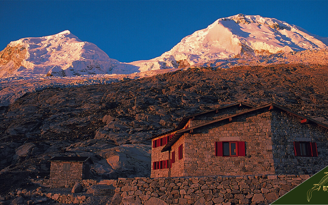
The mountain has two distinct summits, the highest being the southern one (Huascarán Sur), with an elevation of 6,768 meters. The northern summit (Huascarán Norte) has an elevation of 6,654 meters. The two summits are separated by a saddle (called ‘Garganta’). The core of Huascarán, like much of the Cordillera Blanca, is formed by Cenozoic granite.
The summit of Huascarán is one of the farthest points on the Earth’s surface from the center of the Earth, very close to the most distant point in Chimborazo, Ecuador.
Wildlife in Huascarán National Park includes 112 species of birds, such as the Andean Condor, the torrent duck, and the puna partridge. There are also 13 species of mammals, such as the vicuña, the wild cat, the Andean cat, the viscacha, the spectacled bear, the gray deer, the taruca, the Andean fox, and the weasel.
The Raimondi puya, a plant that can grow up to 6 to 12 meters tall, also grows in this area, and there are relict forests of queñuales and puna grasslands.
The travel and tourism agencies of the city of Huaraz offer diverse alternatives to national and foreign tourists who visit the city in search of various trekking and climbing circuits in the Callejón de Huaylas. They organize services of extreme adventure in the mountains of Pisco, Ishinca, Urus, Chopicalqui, Alpamayo, etc. Also, various trekking packages for family and friends, and if you want specialized tours, private expeditions are also organized. Exclusively for one person or groups of people who have booked in advance.
The department of Ancash registered 279,292 visitors between January and December 2021 (+146.8% over the previous year). The most visited site was Huascarán National Park (222,107; +133% from a year earlier).
2022 is shaping up to be a banner year for Peru’s tourism industry, thanks in no small part to the beauty of Huascarán National Park and its snow-capped mountains. The stunning vistas are helping restore optimism as businesses recover from the impacts of COVID-19.
In July 2022, the period of Peruvian national holidays and major national rest days, more than 20,000 tourists visited Huascarán National Park. This number represents a 10% increase in visitors compared to 2021 in that period.
Of the total number of visitors to Huascarán, an estimated 15,681 were of Peruvian nationality; in other words, domestic tourism prevailed during the Peruvian national holidays.
What is the history of Huascarán?
The Huascarán is the highest granite snow-capped mountain in the Peruvian Andes, with an altitude of 6757 meters above sea level. It is located on the border of the provinces of Yungay and Carhuaz, Ancash region, in the orographic sector called the Cordillera Blanca, in the heart of the Huascaran National Park.
The mountain involves two peaks: the north summit at 6655 meters above sea level and the south summit at 6757 meters above sea level, making it the highest point in the country and the entire intertropical zone. If the measurement is made from the center of the Earth, it is the second-highest mountain on the planet, surpassing the height of Everest by almost two kilometers. In 2013 a team of Australian and German researchers revealed that it is the place on the Earth’s surface with the lowest gravitational force of attraction.
Other names given to the mountain were Matarao and Mataraju. Mataraju is the name the local indigenous inhabitants prefer to call the snow-capped mountain. It comes from the Ancash Quechua ancashino mata (twin) and rahu (snow peak), which means ‘twin mountains.’
Antonio Raimondi studied the north side of the massif, reaching 4800 meters above sea level at Portachuelo point on the way to the town of Yanama. Raimondi was the first scholar who traveled the entire region to study its mining potential, recording the results in his book “Ancachs y sus riquezas minerales” (Ancachs and its mineral wealth) of 1873.
Coronation of the north summit:
On August 3, 1908, Annis S. Peck claimed to have reached the mountain’s north summit. In 1927, the Geographic Society of Peru baptized this summit as “Annis Peck Summit” in her honor.
On July 20, 1932, an expedition of the Austro-German Alpine Club, led by Dr. Phillip Borchers, climbed for the first time the south peak at 6768 masl (altitude at that time), the highest peak of the mountain. This expedition consisted of German climbers Philipp Borchers, Wilhelm Bernard, Erwin Hein, Hermann Hoerlin, and Erwin Schneider.
On August 3, 1953, the Peruvian expedition formed by Félix Mautino, the brothers Guido, Pedro, Apolonio Yanac, and Macario Ángeles reached the south summit. The following year, the same expedition members reached the summit of the Argentinean Aconcagua massif, the roof of America.
On July 8, 1953, E. San Vicente and M. Villavicencio ascended the south summit for the first time in the first Mexican expedition. On August 3, 1973, the second Mexican expedition formed by Raúl Bárcena, Guillermo Díaz, Antonio Carmona, and Vicente Hinojosa climbed the north summit for the first time by the normal or ‘La Garganta route.
After a French expedition reached the immense north wall of the north summit in 1966 and another expedition in 1971 opened the first route on the east face of Huascaran Sur, it was up to the Italian mountaineer Renatto Casarotto to write an important page in the history of mountaineering in this massif. The Italian climber opened a challenging route in the middle of the north wall of the north peak; he left the base camp on June 6, 1977, and stayed for 17 days on the wall, carrying about 40 kg of material and food, climbing each section three times (two uphill and one downhill) due to the unique self-insurance technique adopted. At 4:30 pm on June 21, 1977, the Italian climber reached the summit; it took him another two days to return to base camp.
In 1993, Battistino Bonali and Giandomenico Ducoli attempted to climb the north face of Huascaran. On August 8, 1993, when they were 200 meters from the summit, they were swept away by an avalanche that killed them and threw their bodies 1300 meters downhill.
On April 8, 2000, extreme athlete Andai Siebenhofer launched for the first time with a paraglider from the south summit to the Santa River valley. In 2016, Russian BASE jumper Valery Rozov launched for the first time from the top of the east wall on the south peak (6757 masl), gliding in a wingsuit over the east glacier for 30 seconds and landing in Ulta Gorge.
Landslides, earthquakes, and avalanches:
It is known that the first mass displacement of the Huascarán happened about 47,000 years ago; this event is scientifically known as the “Matacoto Event .” This gigantic avalanche was the one that formed the alluvial fan of Yungay and Ranrahirca, through which three avalanches of similar characteristics would later travel.
On January 10, 1962, a landslide caused by a rapid rise in temperature killed some 2,900 people in the village of Ranrahirca and its annexes.
On May 31, 1970, the Ancash earthquake caused a large portion of the snow and rock ledge on the north face to collapse. The avalanche, estimated at 80 million feet of ice, mud, and rocks, was 1.5 km wide. It advanced the 18 km at an average speed of 280 to 335 km/h and buried the villages of Yungay and Ranrahirca, killing more than 20,000 people.
On January 22, 1977, a landslide produced an avalanche that devastated the Puchoc, Sacsha, and Ranrahirca valleys.

What does Huascarán mean?
The first recorded mention of the name Huascarán appeared in 1850 as Huascan on a map made by Antonio Raimondi, a name given by the local population probably because the mountain rises above the town of Huashco, receiving its name from the Quechua word for rope (waska). Also, until the 20th century, the hill lacked a single commonly accepted name but was known by different names in the surrounding towns and villages.
At the beginning of the 20th century, the name appeared as Huascarán, a form that has not changed since then. It seems that the name Huascarán is simply a contraction of Huashco-Urán. When the mountain was mentioned, it was thought of in connection with the town and was called Huashco-Urán or “Beyond and below the town of Huashco.”
Other names given to the mountain were Matarao and Mataraju, Mataraju being the name by which the local indigenous inhabitants prefer to call the mountain, from the Ancashian Quechua mata (twin) and rahu (snow peak), meaning “twin snow peaks.”
What was the role of Huascarán, and by what particular civilization?
The Chavin culture was the most important kingdom in the Huascarán region; however, it was inhabited by the man of the Guitarrero Cave since 12,560 B.C., one of the oldest human settlements in Peru; later, sedentary settlements arose with a social, political, and religious base associated with nature as an essential part of their cultural and religious imaginary, among these civilizations were the Chavín, Recuay and Inca cultures.
What was the most important culture in the Huascaran region?
Chavín de Huántar, or Chavín culture, is an important archaeological culture that was developed in Ancient Peru during the Early Horizon (1200 B.C.-400 B.C.). It was a highly significant formative period which had its epicenter in the city of Chavín de Huántar, approximately two kilometers away from the confluence of the Huachecsa and Mosna rivers in the upper basin of the Marañón River. This city is located in the present-day Ancash department, Peru.
The ruins of this ancient city reveal its past grandeur, reflecting thousands of years of history and a wide array of cultural expressions across many societies. The oldest artifacts date back to as early as 3500 B.C., which hints at a long and complex development process that lasted for centuries.
The archaeological remains of what is deemed Sitio Arqueologico Chavin de Huantar demonstrate some of the most advanced technology available throughout Ancient Peru, such as monumental architecture with elaborate carvings and sculptures depicting both naturalistic and abstract motifs, sophisticated irrigation systems, and complex agricultural terracing techniques. Pottery, metalworking tools (such as stone axes), and other materials were used to create artworks with great sophistication and finesse that still amaze modern scholars today.
The architectural style developed by this culture has been linked to numerous other cultures scattered throughout much of Central and South America, suggesting its far reach beyond just Ancient Peru’s borders. Its influence can be seen on monuments such as El Paraiso in Costa Rica, Cahuachi in Peru’s Nazca Valley, Pañamarca in Ecuador’s northern Andes region, Tiahuanacu in Bolivia’s southern highlands, Sipan in Northern Peru’s Lambayeque region — all these sites have been dated back to between 500 BC – 200 AD — suggesting that their builders knew Chavín de Huántar’s accomplishments well before it officially became part of their cultural heritage millennia later on.
Thanks to recent advancements in archaeological research methods, scholars have uncovered interesting aspects of this culture’s religious beliefs. Specifically regarding their faith in a powerful deity known as “El Lanzon” — a god represented by an anthropomorphic figure carved into one of the temple walls at Chavín de Huántar — whose cult may have resided within certain shamanic rites related to fertility practices common among most Andean populations up until modern times. Furthermore, evidence points out that Chavin was also an important commercial center due to its strategic location along important trading routes connecting different regions within western South America during Precolumbian times; thus helping understand how it gained influence over larger territories even outside what could be considered its own physical boundaries by spreading the religious ideology through trade contact alone.
Altogether, these factors make Chavin de Huantar one of the most interesting archaeological cultures from Prehispanic times, not only within Peruvian territory but also beyond its own regional borders — emphasizing its importance when we analyze Ancient American societies from an intercultural perspective given its very unique characteristics amongst other contemporary civilizations during those days more than 3000 years ago.
What are the theories about the origin of Huascarán?
Listed below are the theories about the origin of Huascarán.
1. The most widely recognized theory about the origin of the Huascarán indicates that during the division of the supercontinent Pangea, the eastern territory of the current Andes Mountains – at that time a plateau with peaks reaching a thousand meters – was an immense and dense sheet that served as a shore to a sea that ran from present-day Colombia to northern Bolivia. This seashore ecosystem with rich, fast-flowing tributaries that descended from the primordial Andes Mountains provided the proliferation of diverse dinosaur species, which left an extensive deposit of footprints and fossils in the current southeastern territory of the national park in terrains that were formed during the Albian stage during the Lower Cretaceous and are now over 4,000 meters above sea level. The massif is composed entirely of granite, an intrusive igneous rock, and its uplift began at the Neogene-Quaternary boundary 5.3 million years ago.
2. The second most important theory is that it is a volcanic peak formed due to tectonic activity in the Andes mountain range. This includes the movement and collision of two tectonic plates, which caused the uplift and the formation of Huascarán. The force created by these plates colliding together triggered magma to rise through Earth’s crust and form a volcano. Over time, the volcano’s lava cooled and hardened, eventually creating Huascarán.
3. Another theory suggests that Huascarán is an ancient remnant of a much larger mountain that has been worn down over time by erosion and other natural processes such as weathering, ice-scouring, and landslides. Evidence for this hypothesis can be found in the presence of river terraces along its slopes, which indicate former high points in elevation where glaciers have retreated over time as they have become smaller due to climate change or other factors.
4. There is also a hypothesis that the Huascarán massif was formed by the collision of two tectonic plates, which caused uplift and mountain formation. This process is known as orogeny. It occurs when two plates with different densities move past each other at convergent plate boundaries, resulting in fold mountains like Huascarán forming along their margins. This process likely took millions of years but resulted in a dramatic geological change to the region’s landscape.
5. Finally, some scientists propose that the Huascarán massif is an erosional remnant, which has been shaped by the action of glaciers and rivers over millions of years. This theory is based on observations such as glacial striations – long parallel lines etched onto rocks – created by glacial movement on former higher surfaces; evidence for older shorelines around Huascaran indicating former sea levels; moraines left behind at specific elevations after glaciers receded; cirques (bowl-shaped depressions) carved out from glaciers; and deep valleys cut into mountainside soils due to rapid water flow from rivers or streams over long periods. All these features suggest that Huascaran was once much larger but gradually diminished over time due to natural erosive processes until what we see today remains.
What are the myths about Huascarán?
Below are listed some of the best-known myths about the Huascarán snow-capped mountain:
The legend of Huascaran.
Huascaran was once a woman who bore numerous children. Huascaran’s husband, Canchon, was seduced by Sutoc, who was a better cook. Jealous, Huascarán castrated her husband and fled, followed by her sons. The eldest accompanied her closely, while the youngest went quite far away. Huascarán carried his favorite son on his back. When they sat down to rest, the whole family was transformed into the Cordillera Blanca, and their tears caused the streams that shaped the Santa and Marañon Rivers.
Canchón turned to stone and became the most beautiful mountain in the Cordillera Negra. His lover Sutoc and his children were also transformed into other mountains. It is said that there was a dynamic and peaceful tribe that bordered others similar to it. Nothing disturbed life in that idyllic place. One day, a badly wounded soldier arrived with an assignment for the great chief. The interview took place, and the soldier said that some warriors of Cusquenian origin had invaded and plundered his town. He said that these Cusquenians were coming in his direction and that it was necessary to prepare to receive them. The great chief had been stunned: could they really face such a powerful enemy? The soldier had told him terrible things about those Cusquenians.
It was enough to see the soldier’s state: he had made his last effort to reach him, and with it, he had spent the last breath of life he had left. After thinking it over, the great chief ordered his best warriors to search for the Cusquenians and present them with a peace policy. Thus, days later, the soldiers returned with Huáscar, the most recognized warrior of the invaders, who was in charge of carrying a message of non-aggression. Huáscar was to stay until the Cusquenian retinue arrived so that he guaranteed peace relations with his presence. Upon receiving the news, the great chief was so happy that he ordered that the guest be given the best care. Everything was going well until one day, a beautiful girl appeared, playing in a water well.
The Cusquenian was captivated: he soon found out her name, Huandy was her name, and he also learned that she was the daughter of the great chief himself. They met for the first time one afternoon when she brought him groceries. They talked, fell in love, and agreed to meet on the riverbank when the night was at its peak. It happened just as they had planned. That night they promised each other never to leave each other. Huandy then reacted: would her father let her stay with a man, not from her tribe? No, he would never do that. If they wanted this love to blossom, they had to run away, and they had to run away as soon as possible. And run they did, but they could have gotten farther. For his part, the big boss was already aware of the events.
Disappointed by the guest’s lack of deference to him and his daughter’s extreme disobedience, he let them escape to catch them on the road and show his fury there. And so he caught them; he humiliated them, and, already satisfied, he tied them to sticks placed in strategic places, from where one could see the other suffer to death. Huascar, in his delirium, thought that his people, upon arriving and seeing him like this, would save him. It was his only hope. But his people did nothing and, on the contrary, praised the determination of the great chief.
Already without illusions, seeing how his beloved was dying, seeing that only a stream separated him from her, feeling the impotence of resignation, he swore then to take revenge someday on those who did not allow them to be happy. He began to cry, and she cried too and did so until she dried up inside; from the maiden’s tears, Lake Chinanchocha (female lake) was formed, and from Huascar’s, Lake Orconcocha (male lake).
It was the last breath. Seeing so much love, the god Inti took pity on them and supported Huascar’s revenge. Rain, thunder, lightning, and hail were what he sent to the tribes in question, and it was so much and for so long that it covered the corpses, thus turning them into the snowy Huascarán (for Huáscar) and Huandoy (for Huandy). It is believed that in 100 or 200 years, the snow-capped mountains will run out of snow, and Huáscar and Huandy will revive and meet again, but this time for eternity.
The legend of Huascarán and Huandoy.
The legend of these two mountains is about a forbidden love between a young princess, Huandoy, daughter of the supreme god Inti, and a humble commoner from the mountain town of Yungay. Despite her father’s disapproval, Huandoy falls in love with a brave and muscular young man named Huascarán, so much so that the two decide to marry. When Inti learns of this union, he punishes his daughter and her lover for their defiance by transforming them into mountains – one known as Huandoy and the other as Huascarán – placing an endless snow-clad blanket over them and curving deep valleys between them so that they would never be able to reunite.
The story tells that both mountains have wept for eternity for being separated, their tears turning into ice as they fall into the vast valley below. Local people often say that it’s possible to feel a chill in the air around these two majestic peaks despite the summer season, some believing that it is not just caused by their height but also due to their heartache.
As such, many people attribute it as proof that true love can still exist despite all odds.To honor this tale of undying love, locals host an annual festival dedicated to these two peaks every year. This includes traditional music performances, dances, and the exchange of local goods – all intended to celebrate this unique bond shared by two isolated mountains in a seemingly infinite wintery landscape.
The festival continues to be celebrated today as families gather annually throughout Yungay in Peru’s Ancash region to share food, stories, and memories about these beloved mountains that will remain together forever in spirit.
Is the Huascaran mountain important to Peru’s history?
Yes, the Huascaran mountain is very important for the history of Peru.
In addition to its magnificent beauty, Mount Huascarán is also the cause of one of the most terrible natural disasters in Peru’s history. In 1970, an earthquake triggered an avalanche that killed 70,000 people and caused the disappearance of Yungay, a small town, and ten nearby villages.
Apart from that, Huascarán National Park is home to 33 sites of archeological importance, most of which are pre-Inca and consist of tombs, viewpoints, terraces, buildings, and irrigation canals. The Callejón de Huaylas was inhabited by cultures such as Chavin (1000 B.C.-200 B.C.) in the Early Horizon period and Recuay (200-600 A.D.) in the Early Intermediate period.
Where is Huascarán Mountain located?
Huascarán is located in the Peruvian province of Yungay (department of Ancash), situated in the Cordillera Blanca of the western Andes. The southern summit of Huascarán (Huascarán Sur), which reaches 6,768 meters, is the highest point of Peru, of the Northern Andes (north of Lake Titicaca), and of the entire terrestrial Tropics. Huascarán is the fourth highest mountain in the western hemisphere and in South America, after Aconcagua, Ojos del Salado, and Mount Pissis, respectively.

What are the coordinates of the Huascaran mountain?
The coordinates of Huascarán are as follows:
DMS
Decimal
9° 7′ 18″ S, 77° 36′ 15″ W
-9.121667, -77.604167
Geo URI
geo: -9.121667,-77.604167
UTM
18L 213768 8990665
How does the map of the Huascaran look?

What is the geography of the Huascaran mountain?
The geography of Huascarán has the following characteristics.
The mountain has two distinct summits, the highest being the southern one (Huascarán Sur), with an elevation of 6,768 meters. The northern summit (Huascarán Norte) has an elevation of 6,654 meters. The two summits are separated by a saddle (called ‘Garganta’). The core of Huascarán, like much of the Cordillera Blanca, is formed by Cenozoic granite.
The summit of Huascarán is one of the farthest points on the Earth’s surface from the center of the Earth, very close to the most distant point, Chimborazo, in Ecuador.
Wildlife in Huascarán National Park includes 112 species of birds, such as the Andean Condor, the torrent duck, and the puna partridge. There are also 13 species of mammals, such as the vicuña, the wild cat, the Andean cat, the viscacha, the spectacled bear, the gray deer, the taruca, the Andean fox, and the weasel.
The Raimondi puya, a plant that can grow up to 6 to 12 meters tall, also grows in this area, and there are relict forests of queñuales and puna grasslands.
What is the geological profile of Huascaran mountain?
The Huascaran Geological Profile has the following characteristics:
The snow-capped mountain is surrounded by numerous peaks above 5,000 meters in the Cordillera Blanca, a 140-kilometer-long snow-covered mountain range that is itself included in the 340,000-hectare Huascaran National Park.
The massif is made entirely of granite, an intrusive igneous rock, and its uplift began at the Neogene-Quaternary boundary 5.3 million years ago.
It is located within the “Cordillera Blanca Batolith” in the territory of the “Cordillera Blanca Active Fault,” a rock discontinuity that extends from the Conococha Lagoon to the south to Corongo in the north.
The massif is a system of 3 peaks with pronounced elevation with respect to the surrounding valleys and nearby massifs, which is why it can be seen generally at a distance of 60 km or 100 km from the coast of Chimbote. The north and south peaks have a moderately sloping west face (the one facing the Callejón de Huaylas), concentrating almost 70% of the glacier area. In contrast, the east face of these peaks drops steeply on rock walls that exceed 70° of inclination; the drop starts from the summit at 6757 m a.s.l. to 5400 m a.s.l. where the glacier tongue is located.
What are the hiking routes in the Huascarán area?
The national park has about 25 trekking circuits and 102 climbing destinations.
We present some options that may be of interest to visitors:
Lake 69 – 4650m (6hrs)
Lake 69 has become increasingly popular in recent years, making it the site of some of the best day treks in the world. The hike is challenging due to the altitude, starting at 3,900m and ending at the aquamarine Lake 69 at 4,650m. After a short 35-minute cab ride from the park entrance, you will arrive at the trailhead. Start on a well-established trail that winds through the Demanda Valley from Cebollapampa, passing a huge waterfall and a small lake that offers open views of the twin peaks of the Huascaran massif. Crossing some ruins, you will reach the last series of switchbacks before resting on the shores of aquamarine Lake 69, surrounded by the peaks of Chacaraju (6112m) and Pisco (5752m).
Santa Cruz – 4750m (3-4days)
The Santa Cruz circuit is a multi-day trek typically completed in 3-4 nights, depending on individual fitness and time constraints. The 50 km trail takes you into the heart of the mountains through open valleys, past meltwater lakes, and up to one of the highest passes in the region: Punta Union (4750 m). At this altitude, the views of the surrounding peaks are unprecedented and allow views of the Andean giants Alpamayo, Santa Cruz, Taulliraju, and Rinrijircas, among others. Trekkers can choose to start at either Vaqueria or Cashapampa, and both routes offer an equally exceptional trekking experience in one of the most picturesque valleys in the Cordillera Blanca region.
Llanganuco Lagoons – 3850m (6 hours)
The Lagunas de Llanganuco is one of the most emblematic hikes in Huascaran Park. Located very close to the park entrance, a short cab ride (30 minutes) will get you to Chinacocha or Orgoncocha. Return to the valley and walk along the lagoons and vertiginous black-walled cliffs, which contrast with the pristine meltwater lagoons creating a spectacular view down into the valley. After skirting the lakes and passing Chinacocha, you will enter the cloud forest and a little-known pre-Columbian trail to descend, hugging the river and passing a waterfall. You will then cross a pre-Inca stone bridge before reaching the park entrance.
Huayhuash Circuit – 5000m (8-10 days)
Peru’s Cordillera Huayhuash circuit is one of the most underrated multi-day treks in South America and the world. High-altitude passes, turquoise lakes, thermal baths, and an abundance of sparkling snow-capped peaks and world-class mountain scenery sum up this adventure. Due to its remote location and demanding route, the trek can take anywhere from 8 to 12 days, depending on whether you hike independently or in a group, your fitness level, and time constraints. However, most people start in Matacancha and finish in the village of Llamac, although there are alternative options. The many notable peaks on the hike are Rondoy, Ninashanca, Jirishanca, Yerupajá chico, Yerupajá, and Siula Grande.
What is the longest trail in Huascarán?
The longest trail in Huascaran National Park is the Alpamayo Circuit. This trail is estimated to be 69.9 miles long and takes an average of 45 h 23 min to hike. The Alpamayo trek is an iconic 7 to 10-day adventure through the heart of the Peruvian Andes mountain range. This stunning alpine route passes through rolling hills and lush high-altitude valleys before ascending over 5000m to the foot of the majestic Cerro Alpamayo peak. Along this journey, hikers will witness a wide array of landscapes ranging from barren, rocky terrain to green meadows with snow-capped peaks in the distance. As hikers reach higher elevations, they will be treated to breathtaking vistas overlooking cloud forests and towering glaciated mountains.
In addition to stunning views and diverse alpine environments, the Alpamayo trek is also home to a wide variety of abundant wildlife, including condors, foxes, eagles, and spectacled bears. In addition, many rare species, such as the Andean goose and Crested Caracara, can be seen along this route. Finally, this trek is ideal for adventurers to explore ancient Inca ruins while immersing themselves in local culture as they traverse remote villages and campsites. With its incomparable beauty, diverse wildlife population, and picturesque scenery.
How many meters high is the Huascarán mountain?
The Huascarán snow-capped mountain reaches a summit of 6,768 m, which makes it the highest point in Peru, the highest snow-capped mountain in the tropics of the world, and the fourth-highest mountain in the western hemisphere. It is also the fourth-highest mountain in South America, the highest being Aconcagua.
When is the best time to visit the Huascarán National park?
The best time to visit Huascarán is between May and October. Especially the months of May and June, respectively, to avoid the rainy season (December to March), which makes it impossible to practice some of the typical activities of the park.
What is the climate like in the Huascaran national park?
The climate in Huascarán Park has two distinct seasons: a rainy season from December to March and a dry season from April to November. During the rainy season, thunderstorms are frequent, and the fields and mountain slopes are covered in many shades of green; however, the dry season brings sunshine almost every day and cloudless but cold nights. Daily temperatures in the rainy season can range from a maximum of 20 °C (68 °F) to a minimum of 5 °C (41 °F), while in the dry season, the maximum can be 24 °C (75 °F) and the minimum of 2 °C (36 °F).
Where to stay in the Huascarán area?
The offer of hotels and lodging places is extensive in the city of Huaraz and the towns of the Callejón de Huaylas. We offer you several options here so that, according to your interests and length of stay, you can choose the one you prefer.
Llanganuco Mountain Lodge
Due to the altitude of some of the hikes, it is necessary to acclimatize appropriately, to avoid the effects of altitude sickness and maximize your enjoyment of the area. Llanganuco Mountain Lodge has a privileged location just 25 minutes from the Huascaran National Park entrance, giving guests excellent access and time to adapt to the environment.
Hotel Columba Huaraz
Hotel Colomba, an ideal option for travelers, is strategically located only six blocks from the main square of Huaraz, northbound.
Enjoy its comfortable and spacious rooms, as well as its gardens, with the services offered: Buffet breakfast, room service, free WiFi, children’s games, green areas, fronton court, and parking; Renovated dining room with lunch and dinner a la carte (only in season), living room with fireplace.
The hotel also has the traditional Cebu Beer and Sol de Oro Huaraz, both handcrafted and table water.
Hotel Colomba – Hotel El Patio de Monterrey
El Patio de Monterrey is a comfortable hotel. It is located 6 km from the center of Huaraz, in the town of Monterrey, away from the noise of the city, it is very easy to reach, it is located on the road Huaraz – Caraz, on the way up to the thermal baths of Monterrey. It is a country-style hotel with extensive gardens that allow our guests a pleasant rest and comfort. It has several types of rooms and cabins.
Hotel Villa Valencia
Featuring a restaurant, free private parking, a fitness center, and a bar, Hotel & Bungalows Villa Valencia offers accommodation in Huaraz, 1.2 km from Rosas Pampa Stadium. The property has a garden and is 10 km from Chilán. The property has a 24-hour front desk, airport shuttle service, room service, and free WiFi.

What are the tours in the Huascaran national park?
Below is a list of the most important tours and activities to do in the Huascaran National park.
The Santa Cruz Trek:
This is one of the most popular treks in the Huascarán National Park and takes visitors through the beautiful Santa Cruz valley, passing through small Andean villages, high-altitude grasslands, and alpine forests. The trek typically takes 4-5 days to complete and offers an array of stunning views of the surrounding mountains, glaciers, and rivers. You will explore vibrant local culture and sample traditional Andean cuisine along the trek. The route starts at Laguna Llanganuco before ascending to the Santa Cruz Pass at 4750m above sea level. From there, it continues through pristine mountain scenery until you reach a peak of 7200m at Nevado Alpamayo.
The Huascarán Summit Trek:
This trek is considered one of the most challenging in the park and takes visitors to the summit of Huascarán, the highest mountain in Peru. The hike typically takes 8-10 days to complete and requires a high level of physical fitness and adequate acclimatization. You will traverse diverse landscapes such as the alpine tundra, rugged ridges, and snow-capped peaks before reaching your final destination – Huascarán’s summit at 6768 m above sea level! There will be plenty of opportunities for mountaineering skills, such as ice axe technique on steep sections or glacier travel with crampons on icy terrain as you ascend towards your ultimate goal.
The Llanganuco Trek:
It is an amazing experience that takes visitors through the beautiful Llanganuco valley, home to two glacial lakes – Chinancocha and Orconcocha. The trek usually lasts 2-3 days, depending on your available time. During this tour, you’ll be able to admire spectacular views of snow-capped peaks such as Huascarán (6768m) and Pisco (5752m). In addition to these fantastic panoramas, you’ll also get a chance to observe some rare Andean wildlife including condors soaring in flight across vast valleys below or majestic vicunas grazing along rocky outcrops! The trail culminates with a visit to a rustic Inca bridge that still stands after centuries – a testament to both Peruvian engineering prowess and Inca resilience.
Cultural tours in Huascarán National Park allow visitors to explore the region’s ancient history and traditional culture. These tours take guests to visit the Chavín de Huántar archaeological site, which was once an important religious center for those who practiced the Chavín religion. Additionally, visitors can explore pre-Incan ruins and traditional Andean villages to learn more about these people’s customs, traditions, and beliefs.
Wildlife-watching tours:
These tours allow travelers to observe some of the most iconic species in this park. From soaring Andean condors to vicuña grazing on alpine meadows or a Spectacled bear foraging for food, there is always something new and exciting waiting around every corner. On these tours, visitors may also get lucky enough to spot some rare endemic animals, such as yellow-tailed Woolly monkeys and taruka deer, that are unique to Peru’s mountain regions.
Climbing tours:
They offer adventurers a thrilling experience as they tackle challenging peaks such as Alpamayo or Pisco. These tours usually start from one of Huascarán’s base camps located at different elevations along its main trails, where guests can rest and prepare for their next ascent. Professional guides lead these trips and help climbers make it safely up and down these mountains while educating them about their environment.
What are the closest destinations to the Huascaran national park?
The closest and most exciting destinations to Huascarán are the following:
- Mount Huandoy. Mount Huandoy is a striking mountain with a sharp peak. It is one of the most famous mountains in the park and an attraction for many climbers. It reaches a summit of 6,360 meters. It is the second-highest mountain in Peru and in the Cordillera Blanca. The glacial valley of Llanganuco is located between Huandoy and its neighbor, Huascaran. The mountain has four different peaks, the Huandoy being the highest, the Huandoy-West at 6,456 m, the Huandoy-South at 6,160 m, and the Huandoy-East at 6,000 m.
- Llanganuco Lagoon. It is part of the Huascaran National Park and is located 84 kilometers from the city of Huaraz and 25 kilometers from Yungay, at an altitude of 3,850 meters above sea level. It comprises two lakes, Chinancocha (Laguna Hembra) and Orcococha (Laguna Macho).
- Chinancocha is a Quechua expression that means Female Lagoon. This magnificent natural scenery is located in a narrow glacial valley between the Huascarán and Huandoy snow-capped peaks; its waters are turquoise green, surrounded by dense Queñuales forests.
- Chavín de Huántar. It is an archaeological site with ruins and artifacts built since 1200 B.C. and occupied until around 400-500 B.C. by the Chavin culture. The site is at an altitude of 3,180 meters, east of the Cordillera Blanca and the beginning of the Conchucos valley.
- Yungay. It is a small town located at the foot of Huascaran. In 1970 the original village was destroyed by a colossal avalanche caused by an earthquake, which buried tens of thousands of people. It is an emotional place with gardens full of roses surrounding the church and a couple of trees that, together with the cemetery, were the only things left standing after the disaster.
How to get from Lima to Huascaran?
Below is the most complete list of how to get to Huascaran from Lima.
- Begin your journey to Huascaran National Park by traveling from Lima to Huaraz, located in the Ancash region of Peru and serves as the main gateway for accessing the park. The drive takes about 9 hours by car and can be done by hiring a private driver or taking a bus from Lima’s Cruz del Sur terminal.
- Once you arrive in Huaraz, you have several options for reaching the park: you can take a taxi, rent a car, or book a guided tour. The journey to Huascaran National Park will take around 2-3 hours, depending on traffic and road conditions.
- When you reach Huascaran National Park, stop at one of the visitor centers located in Carhuaz or Yungay (the two main cities within the park boundaries) and get an orientation about the park rules and regulations before heading out on your outing.
- With an area of 340 square miles (880 sq km), Huascaran National Park is home to numerous species of wildlife, stunning landscapes, and stunning peaks such as Mount Huascaran (22,205 ft – 6,768 m). Therefore it is important to plan and pick an activity that suits your preferences and goals for this trip: trekking through trails like Quilcayhuanca Valley; mountaineering activities such as climbing Nevado Pastoruri (17,909 ft/5452m); biking along Vallunaraju peak; birdwatching; or just admiring the local flora and fauna while camping overnight!
- Ensure that you are adequately prepared with all necessary equipment before embarking on any adventure inside the park: camping gear should include tents and sleeping bags suitable for high altitude levels; trekking essentials should include good quality hiking boots; mountain bikes should be equipped with appropriate safety measures such as helmets; camera equipment should include extra batteries since power outlets might not be available; always bring enough food and water if planning to stay overnight or heading off into more remote trails!
- Do not forget to check with local authorities regarding potential weather changes during your visit – sudden changes in temperatures may occur due to climatic conditions resulting from its location between mountains and sea level – so plan accordingly.
What to know before going to Huascaran?
The following are the most imprortant recommendations if you visit Huascaran National Park.
- Wear specialized shoes for long walks.
- Warm clothing
- Tent and sleeping bag
- Gloves
- Mosquito repellent and sunscreen
- Sunglasses
- Rainwear
- Special shoes for walking in the snow.
- Confirm that your tourism agency is authorized by the National Service of Natural Areas Protected by the State (Sernanp).
- To enter the park, it is mandatory to be accompanied by a guide and specialized personnel.
- If you suffer from altitude sickness, drink plenty of water and walk around the city of Huaraz for at least one or two days before starting any trekking in the highlands.
- If you are going to climb Huascaran, remember that specialized agencies require a minimum local acclimatization of four days.
If you are considering ascending Huascarán, take into account the following recommendations:
- 40 to 70 l backpack for the whole circuit.
- Waterproof jacket and pants (Gore-Tex or similar).
- Warm polar clothing (Polartec or similar).
- Thermal clothing (first layer).
- Short and long sleeve T-shirts.
- Waterproof hiking shoes (must cover the ankle).
- Sufficient batteries (no power to charge devices on the road).
- Havaianas (for showers, rest, and river crossings, if necessary).
- Flashlight.
- Towel.
- Hat and gloves for cold weather.
- Sun hat.
- Sunscreen.
- Sunglasses.
- Camera.
- Personal first aid kit.
- Water bottle (Nalgene or similar).
- Personal bag with toiletries.
- Ziploc bags or similar (to store your garbage).
- Trekking poles.
- Sleeping bag.
- Medical insurance.
What is the Huascaran National park itinerary like?
The itinerary to visit Huascarán National park is as follows:
Day 1: Arrival in Huaraz and acclimatization. Explore the city of Huaraz and visit the local market, then take a short hike to nearby Mirador de la Cruz for a panoramic view of the city and the Cordillera Blanca. Finally, rest and acclimatize to the altitude.
Day 2: Llanganuco Lagoon and Huascarán South Base Camp. Travel by car to the Llanganuco Lagoon, located at the base of Huascarán South. Hike to the base camp and explore the area. In the afternoon, return to Huaraz.
Day 3: Guided tour of the Laguna 69. This glacial lake, located at an altitude of 4,660 meters (15,260 feet), boasts a crystal clear blue hue and stunning views of the nearby peaks. You can see some of the highest mountains in Peru, including the Huascaran summit at 6,768 meters (22,205 feet). You’ll also have a chance to spot wild animals like llamas, vicuñas and alpacas roaming around.
Day 4: Today you will explore one of Peru’s deepest lagoons, Laguna Paron. This picturesque body of water is nestled within an impressive mountain valley near the basecamp for Huascarán summit expeditions. Enjoy spectacular views as your boat winds through this tranquil lake surrounded by snow-capped peaks.
Day 5: Hop on a bike today and cycle around Lake Chiurucu. Start from a small village called Cancha Cancha on its west side, pedal to its east side where you’ll connect with various trails that wind through lush meadows boasting incredible views towards Cordillera Blanca’s high summits.
Stop off along the way for photo opportunities or camp out overnight under starry skies if you’d like more time exploring this beautiful landscape.
Day 6: Take a break from trekking and get to know another side of Huascaran National Park—the Quechua culture. Visit one of the local villages where you’ll see traditional Andean handicrafts being made, sample some delicious local cuisine and even take part in ancient rituals like Pachamama offerings or cleansing ceremonies using medicinal herbs.
Day 7: Wrap up your visit with an unforgettable horseback ride through Quebrada Llanganuco Gorge. As you make your way down this narrow canyon flanked by towering walls formed by glaciers millions years ago, take in breathtaking views towards Yanapaccha peak flanked by cascades spilling down across jagged rocks – it’s guaranteed to be an experience that you won’t forget anytime soon.
Nevado Huascarán has two peaks: the north, at 6655 meters above sea level, and the south, at 6768 meters above sea level, the latter being the main peak and the most climbed during the season.
The ascent usually takes the normal route and constitutes a tremendous physical and mental challenge due to the route through its vast glacier. Another route is the famous ‘Escudo,’ an ice wall about 900 m long, which is a challenge for mountaineers with experience in technical climbing.
The conditions of the route and the glacier change year after year; even during the climbing season, many difficult sections, such as seracs, deep crevasses, and avalanches, must be overcome during the ascent.
Huascarán, unlike the other highest mountains in the American continent, has the most challenging ascent. Proof of this is that it has a chute from Camp I to Camp II with a high probability of seracs (large blocks of ice fragmented by large cracks) on its way and in its ‘Escudo’ route, where resistance in technical climbing is essential.
Suppose your objective is to climb Aconcagua or around 7,000 in the Himalayas. In that case, we recommend climbing Huascaran: it will give you experience and acclimatization to the ideal altitude for the great challenges that await you.
What is the Huascaran Mountain climb itinerary like?
The most known itinerary to climb mount Huascaran is as follows:
Huaraz – Musho – Base Camp
Once the bus has picked you up, you will head towards the Callejón de Huaylas.
You will pass through Yungay and continue on to the town of Musho, at an altitude of 3050m.
Mules will be waiting at this location to transport the logistical material.
Finally, you will arrive at Huascarán base camp at an altitude of 200 m.
Base Camp – Moraine Camp
We set up camp and then hike through the rocks to the Huascaran Moraine Camp at an altitude of 850m.
You will have lunch and spend the afternoon resting and watching the sunset over the mountains.
Moraine Camp – Camp One
Again, the camp will be set up, and then we will advance through the rocks to the entrance of the glacier.
Together with the tour team, you will make an ascent to reach Huascaran Camp One at 5350 m altitude.
After 5 hours of hiking and climbing, you will arrive at Camp One to spend the night there.
Camp One – Camp Two
You will walk to the ravine or canaleta, a route that will take you to Huascaran Camp Two at an altitude of 6010 m.
This is where we will set up camp, have dinner and enjoy the sunset before bed.
Camp Two – Summit – Camp Two
Once the day has started, you will walk on ice and snow platforms for 7 hours until you reach the summit at 6768 m (26,768 ft).
In this place, you will be able to observe the Cordillera Blanca in all its splendor, weather conditions permitting.
Then we begin the descent by rappeling to follow the same route to the summit and then descend to Huascaran Camp Two.
After a 5-hour crossing, you will rest and spend the night.
Camp Two – Camp One – Moraine Camp
The team will set up camp and descend to the Huascaran Moraine Camp, passing through Camp One.
You will arrive at this place after 6 hours of crossing, and it will be your last night of the tour.
Moraine Camp – Musho – Huaraz
Prepare your belongings and equipment for a 5-hour hike at the beginning of the day.
You will pass through the base camp, where the bus will be waiting for you again to transport the equipment to the city of Musho. Here you will take a 2-hour bus ride to Huaraz.
How much does it cost to visit Huascarán National park?
Visiting Huascarán can vary in cost depending on the level of accommodation and activities you choose. Budget travelers can expect to spend around $30-50 per day, while those looking for more luxurious options may spend upwards of $150 per day The admission fee for both adults and children is 80 Peruvian Soles (PEN) per person, or roughly USD 24. In addition, visitors will need to obtain permits from the park’s administrative office near Yuraccancha, which costs about another 20 PEN (USD 6). While prices can vary depending on the time of year and special events occurring in the area, it is important to note that additional expenses are involved in visiting Huascarán that may not be immediately obvious.
For instance, a full-day hike through the park will require an additional guide fee of 20 – 30 PEN ($6 – $9 USD) and rental fees for items such as camping equipment and supplies ranging from 5 – 10 PEN ($2 – $3 USD). Additionally, transportation costs to and from Huascarán should be considered, with bus tickets costing around $20-30 and private car rentals starting at around $70 per day. Overall, a visit to Huascarán can be done on a budget or be a more extravagant experience, depending on your preferences and financial means.
What is the best vehicle to visit Huascaran?
The best vehicle to visit this natural wonder combines a bus and car trip. First, traveling by bus from Lima to Huaraz is recommended for those with complications due to the area’s altitude. You can also enjoy some stunning landscapes of Peru as you make your way closer to your destination, which is 400 kilometers away from Lima.
Once in Huaraz, renting or using your own car is the most popular choice for visitors coming from Lima. It’s essential to check your car’s engine if you are driving since it gets significantly colder at higher altitudes. Make sure to fill up at gas stations before reaching Huaraz and get familiar with the roads, so you know where to stop.
The Huascarán snow-capped mountain can only be accessed by a four-wheel drive vehicle since it is located in a remote area with bumpy roads. Be sure to equip yourself with warm clothing, water bottles, and snacks before heading out.
How many hours should a person spend in Huascarán?
A person should spend at least a week exploring the Huascarán national park in Peru, as this provides ample time to take in the beautiful scenery and enjoy all of the activities available. This national park is home to some of the highest peaks in South America, with Huascarán reaching an impressive 6,768 meters. The area is known for its amazing trekking routes, many of which offer stunning views of the surrounding snow-capped mountains. There are also plenty of opportunities for wildlife spotting – from condors and llamas to spectacled bears – as well as bird-watching since it’s home to some of the world’s rarest species, such as the Andean cock-of-the-rock and other hummingbirds.
Moreover, the Huascaran National Park can be visited all year round. The opening hours are from 7 am to 3:30 pm. However, 7:30 am is the park’s opening and entrance time.
The Huascarán National Park also has a rich cultural heritage that visitors can explore by visiting local communities and learning about their traditions. It’s also possible to take part in archaeological explorations or explore some of its many caves, where ancient Inca wall paintings can be found. For those who prefer to stay above ground, plenty of organized day trips will take you around the national park, enabling you to learn more about its history and marvel at its natural beauty.
What is the closest town to Huascaran?
Huaraz is the closest city to Huascaran, and the distance is 70 kilometers. By car, you can reach the snow-capped mountain in two hours.
What are the books to learn about Huascarán?
Some books you can read to learn a little more about Huascarán are the following:
- John Biggar: The Andes – A guide for climbers, 3rd edition, 2005.
- Brad Johnson: Classic Climbs of the Cordillera Blanca, 2009
- David M. Sharman: Climbs of the Cordillera Blanca of Peru, 1995.
- Juan José Tomé Nacle: Climbing in the Andes (Guide to the Cordillera Blanca).
- Antonio Gómez Bohórquez and Juan José Tomé Nacle: La Cordillera Blanca de los Andes, Ed. Desnivel 1998.
Who are the scientists who worked in Huascaran?
The Italian scientist Antonio Raimondi was the first scholar to travel throughout the region to study its mining potential, recording the results in his book “Ancachs y sus riquezas minerales” (Ancachs and its mineral wealth) of 1873.
At the beginning of the 20th century, exploration trips to Huascarán and the Cordillera Blanca gained importance thanks to the visits of numerous European and North American scientists sponsored by universities and geographic institutes who studied this section of the Andes Mountains. The British Reginald Enock, the American Annie Peck, and the German scientists G. Steinman (geologist), W. Sievers (geographer), and August Weberbauer (botanist) attributed an approximate height of 7300 m asl.
Coronation of the north summit
Annie S. Peck claimed to have reached the mountain’s north summit with the alpine guides Taugwalder and Zumtaugwald, accompanied by two Yungaino porters. In 1927, the Peruvian Geographical Society named the peak “Cumbre Ana Peck” in her honor.
The first ascent to the south summit
On July 20, 1932, an expedition of the Austro-German Alpine Club, led by Dr. Phillip Borchers, after ascending by the “La Garganta Route,” climbed for the first time the south peak with 6768 m asl (height at that time), the highest of the mountain. This expedition was formed by the German climbers Philipp Borchers, Wilhelm Bernard, Erwin Hein, Hermann Hoerlin, and Erwin Schneider, reaching the summit after 5 days of ascent.
In 2019, scientist Lonnie Thompson extracted ice samples from Huascarán to study climate change.
How is Huascarán’s past presented to visitors?
Mexican journalist Astrid Arellano recommended visiting Huascarán.
#VirtualExpedition: a trip to Huascaran, the heart of the Andes in Peru.
by Astrid Arellano on August 26, 2022
Huascarán protects the great Cordillera Blanca, the largest tropical mountain range in the world.
The National Park has 532 glaciers and 410 lagoons, which makes it an excellent water reservoir to sustain life in the region.
Whoever visits the Huascaran National Park in Peru will be impressed by the beauty of its landscape. The color of the water, the immensity of its snow-capped mountains, the verticality of its walls, and the sensation of closeness that gives the impression that you can touch them make it a unique place.
Huascarán was declared a National Park on July 1, 1975. Its exceptional characteristics were why it was designated as a Biosphere Reserve in 1977 and a Natural World Heritage Site by UNESCO in 1985.
Huascarán is also known as “The High Altitude Park” because the mountain range, its geological formations, and snow-capped peaks – with altitudes ranging from 5,000 to 6,7,768 meters above sea level – make it an iconic site.
In addition, its snow-capped mountains feed the Santa, Marañón, and Pativilca river basins. In many of these areas, you can practice activities such as trekking, hiking, climbing, and camping, among others.
In its floristic diversity, the Bromeliaceae family is represented by the Puya Raimondi, a species with the largest inflorescence in the world and is one of the park’s conservation targets. Stands of this species can be seen mainly in the Carpa and Queshque streams.
The park registers more than 120 bird species and 10 mammal species. Among the birds are the Andean Condor (Vultur gryphus), an emblematic bird of South America, the torrent duck (Merganetta armata), and the puna partridge (Tinamotis pentlandite).
Mammals include the bobcat (Oncifelis colocolo), the Andean cat (Oreailurus Jacobita), the spectacled bear (Tremarctos ornatus), the taruca (Hippocamelus antisensis), and the vicuña (Vicugna vicugna). Other species include the gray deer (Odocoileus virginianus), the puma (Puma concolor incarum), the viscacha (Lagidium peruanum), the weasel (Mustela frenata agilis), the añaz (Conepatus sp.) and the Andean fox (Pseudalopex culpaeus).
The most important thing about the protected area is its environmental services to the surrounding population and those not so close; it also provides them with large quantities of clean air and good-quality water.
How is the preservation of Huascarán?
Huascaran National Park was created to protect and preserve the impressive and picturesque mountains of the Cordillera Blanca. The park protects the highest mountain in Peru and the fourth highest in South America.
The park also protects the world’s largest tropical glacier area and the world’s highest tropical-based mountain range. This is a unique set of natural wonders, and we must do all we can to protect this extraordinary pristine wilderness.
Is Huascarán a UNESCO World Heritage Site?
The Huascaran National Park is a UNESCO World Heritage Site in 1985. The park was created ten years earlier and comprises the Cordillera Blanca in Peru. The world heritage property covers some 340 hectares in area and is currently managed by the Peruvian Network of Natural Protected Areas. This national park is famous for its mountain passes and mountaineering spots, and it is also protected to preserve its unique biodiversity of plant and wildlife species.
Has Huascaran become extinct?
Yes, Huascarán Mountain, located in Peru, was a volcano that is now extinct. Although it is not currently an active volcano, there have been signs of potential activity, with small earthquakes occurring in the area as recently as 2012. Despite this, the mountain is technically classified as extinct due to its long period of dormancy.
The Huascarán Mountain lies within Peru’s Cordillera Blanca mountain range and stands at 6,768 m (22,205 ft). The mountain range contains numerous mountains and volcanoes formed from ancient volcanic eruptions that occurred between 55 million and 15 million years ago. One of these volcanoes is Huascarán Mountain which has been inactive for centuries.
Geologists have studied the area to analyze various aspects, such as seismic activity and deformation caused by earthquakes, to determine whether or not Huascaran may become active again. However, their research suggests this is unlikely due to the lack of significant seismic activity near the mountain over recent decades. Additionally, studies of the area surrounding the mountain show no signs of renewed magmatic activities and therefore indicate that it remains dormant today.
So, in conclusion, while Huascarán Mountain was once an active volcano at some point in time in its history, it can now be classified as an extinct volcano due to its extended period without any volcanic activity or indications thereof.
Is Huascarán in danger?
Huascarán National Park, located in the Callejón de Huaylas, is in danger: it could disappear because it is being affected by global warming.
Is Huascarán collapsed?
The Huascarán is not collapsed but is in danger of being so. Climate change and global warming are putting Huascarán, an iconic snow-capped mountain, in grave danger. Should this temperature rise continue unchecked, the nearby lake stands to overflow near Chavín de Huántar – a 900 BC archaeological site renowned for its ancient pre-Inca treasures spanning over 900 temples.
Thanks to the joint study of the Geological and Mining Institute of Peru and the University of Waterloo, it is known that the first mass displacement of the Huascarán happened 47,000 years ago; this event is known as the “Matacoto Event.” This gigantic avalanche was the one that formed the alluvial fan of Yungay and Ranrahirca, through which three avalanches of similar disastrous characteristics would later travel.
On January 10, 1962, a landslide caused by a rapid rise in temperature killed some 2,900 people in the village of Ranrahirca and its annexes.
On May 31, 1970, the Ancash earthquake caused a large part of the snow and rock ledge on the north face of Huascaran to collapse. The avalanche, estimated at 80 million feet of ice, mud, and rocks, advanced at an average speed of 280 to 335 km/h and buried the towns of Yungay and Ranrahirca, killing more than 20,000 people.
On January 22, 1977, a landslide produced an avalanche that devastated the valleys of Puchoc, Sacsha, and Ranrahirca. The population of these localities took refuge in the neighboring hills.

Miguel is a professional tour guide from Cusco, Peru, with almost 20 years of experience leading tours and a deep knowledge of Peru’s cultural and ecological diversity. He is also an advocate of ecotourism and cultural sensitivity and has lectured on these topics in the US and Europe. He co-founded Evolution Treks Peru, a worker-owned travel company based in Cusco.


