
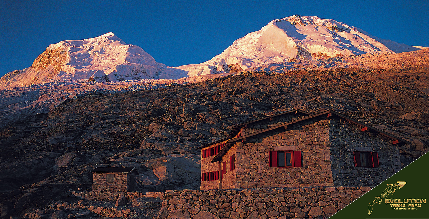

Huascarán is the highest mountain in Peru and in the tropics, a twin-summited granite massif in the Cordillera Blanca of Áncash. Its south summit, Huascarán Sur, rises to 6,768 m (22,205 ft). The mountain gives its name to Huascarán National Park, a 340,000-hectare protected area that UNESCO inscribed as a Natural World Heritage Site in 1985.
| Key fact | Value |
|---|---|
| Height (Huascarán Sur) | 6,768 m (22,205 ft), traditional figure |
| Location | Cordillera Blanca, Yungay Province, Áncash |
| Gateway town | Huaraz, 3,052 m (10,013 ft), about 400 km (250 mi) and 8 hours by bus from Lima |
| National park | 340,000 ha, created 1975, UNESCO World Heritage Site 1985 |
| Park entry, foreign visitor (2026) | S/30 for 1 day, S/150 for 4–30 days |
| Lake 69 and Nevado Pisco | Authorized operator only, since February and April 2026 |
| Best months | May to September (dry season) |
| Time to climb Huascarán | 6–7 days from Huaraz, with a certified guide |
In this guide
- What’s new at Huascarán in 2025–2026?
- What is Huascarán?
- Where is Huascarán located?
- How high is Huascarán?
- What does the name Huascarán mean?
- How was Huascarán formed?
- What is the history of Huascarán?
- What is Huascarán National Park?
- What are the best hikes in Huascarán National Park?
- Can you climb Huascarán?
- Huaraz food, people and festivals
- How do you get to Huascarán National Park?
- When is the best time to visit Huascarán?
- How much does it cost to visit Huascarán National Park?
- Safety and honest notes
- Is Huascarán in danger from climate change?
- What is near Huascarán?
- Frequently asked questions about Huascarán
What’s new at Huascarán in 2025–2026?
The biggest change at Huascarán in 2025–2026 is that Lake 69 and Nevado Pisco can no longer be visited independently. Several other rules, rankings and transport links also changed. Each item below is dated so you can judge how current it is.
- 9 February 2026 – Lake 69 operator-only. SERNANP, Peru’s protected-areas service, now sells Lake 69 tickets only to authorized tour operators. Independent hikers cannot buy them.
- 25 February 2026 – more operators. SERNANP signed 12 new operator contracts for the park, according to El Peruano. Park chief Abdías Villoslada Taipe said the aim is a safe, high-quality visit.
- 1 April 2026 – Nevado Pisco operator-only. Pisco (5,752 m), the usual acclimatization peak before Huascarán and Alpamayo, follows the same rule as Lake 69.
- January 2026 – Level 4 ranking. MINCETUR gave the park Peru’s highest tourism ranking, the same category as Machu Picchu and the Nazca Lines.
- December 2025 – swimming ban reinforced. Rangers reported visitors swimming for social-media videos in Lake 69, Laguna Parón and Llanganuco, where swimming is banned, and SERNANP stepped up monitoring.
- July 2025 – 50th anniversary. The park turned 50 on 1 July 2025. The government announced S/17.5 million for visitor facilities at Llanganuco.
- June–July 2026 – a deadly climbing season. An avalanche killed two climbers on Tocllaraju, another killed a porter on Huascarán, and three Peruvian climbers went missing high on Huascarán. The Camp 1–Camp 2 section closed for 15 days. See safety and honest notes.
- July 2026 – new height survey and two daily flights. A GPS survey measured the summit at about 6,755 m, and LATAM moved to two daily Lima–Huaraz flights.
- June 2026 – festival heritage status. The Señor de la Soledad festival in Huaraz was declared Cultural Heritage of the Nation.
Which sites need an authorized operator in 2026?
In 2026, Lake 69 and Nevado Pisco need an authorized tour operator, and climbs such as Huascarán need a certified mountain guide. Other sites, such as Llanganuco, still sell tickets directly to visitors. Rules can change during the season, so confirm before you go.
| Site | Independent visit (2026) | Rule since |
|---|---|---|
| Lake 69 (Laguna 69) | No, authorized operator only | 9 February 2026 |
| Nevado Pisco | No, authorized operator only | 1 April 2026 |
| Huascarán climb | Register with the park; a certified mountain guide is strongly recommended and often required | Confirm at the park office in Huaraz |
| Llanganuco (Chinancocha) | Yes, ticket online or at the control post | – |
What is Huascarán?
Huascarán is a twin-summited granite mountain and the centrepiece of the Cordillera Blanca, the largest glaciated range in the tropics. The south summit (Huascarán Sur, 6,768 m / 22,205 ft) is Peru’s highest point. The north summit (Huascarán Norte, 6,654 m / 21,831 ft) is lower, and a glacial saddle called the Garganta (“the throat”) joins the two.
The name Huascarán refers to two things that travellers often confuse:
- Huascarán (the mountain) – the massif itself, a technical mountaineering objective.
- Huascarán National Park – the protected area covering most of the Cordillera Blanca, including Lake 69, the Llanganuco lakes, the Santa Cruz trek and Alpamayo.
Most visitors never set foot on the mountain. They see it from the trails, lakes and passes of the national park, which is the focus of most of this guide.
Where is Huascarán located?
Huascarán is located in the Cordillera Blanca of north-central Peru, in Yungay Province, Áncash. Huaraz, the regional capital at 3,052 m (10,013 ft), is about 400 km (250 mi) north of Lima by road. The nearest towns are Yungay, Mancos and Musho, in the Santa River valley known as the Callejón de Huaylas.
The coordinates of the Huascarán Sur summit are 9°07′18″ S, 77°36′15″ W (decimal: -9.121667, -77.604167).

How high is Huascarán?
Huascarán Sur is 6,768 m (22,205 ft) high, the figure used by UNESCO and the Peruvian news agency Andina. This makes it the highest mountain in Peru, the highest point in the tropics, and the fourth-highest mountain in South America. Only Aconcagua, Ojos del Salado and Monte Pissis are higher.
Newer surveys give a lower figure. The table shows the three measurements and their sources.
| Survey | Year | Height of Huascarán Sur |
|---|---|---|
| German-Austrian Alpine Club (DAV) expedition | 1930s | 6,768 m (22,205 ft), the traditional figure |
| INAIGEM GNSS survey | 2017 | about 6,757 m (22,169 ft) |
| Eric Gilbertson GPS survey | July 2026 | about 6,755 m (22,162 ft) |
INAIGEM is Peru’s national glacier and mountain research institute. Gilbertson’s survey is published on Country Highpoints, and he attributes the small drop to melting summit ice. This guide uses the traditional 6,768 m, the figure still used by UNESCO, SERNANP and most maps.
The north summit, Huascarán Norte, is 6,654 m (21,831 ft). The mountain’s topographic prominence is 2,776 m (9,108 ft).
Two further superlatives belong to the summit. Because the Earth bulges at the equator, it is the second-farthest point from the planet’s centre, after Chimborazo in Ecuador. In 2013 a gravity study led by Christian Hirt of Curtin University found it has the lowest gravitational acceleration on Earth, about 9.7639 m/s².
What does the name Huascarán mean?
The name Huascarán most likely comes from the village of Huashco below the mountain, from the Quechua word waska (“rope”). The mountain first appeared on record as “Huascan” in 1850. Huascarán is probably a contraction of Huashco-Urán, “beyond and below the village of Huashco”.
Local Quechua speakers also call the massif Mataraju. The name comes from Ancash Quechua mata (“twin”) and rahu (“snow peak”), meaning “twin snow peaks”.

How was Huascarán formed?
Huascarán was formed by the uplift of a granite batholith, not by volcanic activity. Its core, like most of the Cordillera Blanca, is Cenozoic granite: magma that cooled slowly underground. It was later pushed upward along the Cordillera Blanca Fault, which runs along the western foot of the range.
Uplift accelerated in the last few million years. Glaciers then carved the summits, cirques and U-shaped valleys seen today. The western slopes are moderately inclined and hold most of the ice, while the eastern faces drop in steep rock and ice walls.
What is the history of Huascarán?
The history of Huascarán spans 10,000 years of settlement, a century of mountaineering and two of the deadliest mountain disasters on record.
Who lived around Huascarán before the Incas?
People have lived around Huascarán for more than 10,000 years. Guitarrero Cave, in the Callejón de Huaylas, is one of the oldest archaeological sites in Peru. Later the Chavín culture (c. 1200–500 BC) built Chavín de Huántar east of the range. The Recuay culture (roughly the 1st to 7th centuries AD) followed, and the Incas arrived in the 15th century.
Who first climbed Huascarán?
The first ascent of Huascarán Sur was made on 20 July 1932 by a German–Austrian Alpine Club expedition. The climbers were Philipp Borchers, Bernard, Erwin Hein, Hermann Hoerlin and Erwin Schneider. They climbed through the Garganta, which is still the normal route.
| Date | Event |
|---|---|
| 1873 | Italian-born Peruvian scientist Antonio Raimondi publishes his study of Áncash’s geography and minerals. |
| 2 September 1908 | American climber Annie Smith Peck, with Swiss guides Rudolf Taugwalder and Gabriel Zumtaugwald, reaches Huascarán Norte. Most sources accept the ascent, but it has been questioned. |
| 20 July 1932 | First ascent of Huascarán Sur by the German–Austrian expedition. |
| 1977 | Italian Renato Casarotto completes a 17-day solo new route on the north face of Huascarán Norte. |
What disasters has Huascarán caused?
Huascarán has produced two of the deadliest avalanches in recorded history, both from its north summit.
- 10 January 1962: An ice and rock avalanche from Huascarán Norte destroyed Ranrahirca and nearby settlements. It killed an estimated 3,500–4,000 people.
- 31 May 1970: The magnitude 7.9 Áncash earthquake detached part of the north face. About 80 million m³ of ice, rock and mud travelled roughly 18 km at 280–335 km/h (175–210 mph). It buried Yungay and Ranrahirca and killed more than 20,000 people; the earthquake killed about 67,000 across Peru.
The site of old Yungay is now the Campo Santo memorial, a protected burial ground. New Yungay was rebuilt nearby.
What are the legends of Huascarán?
The best-known legend tells of Huáscar, a young warrior, and Huandy, a chief’s daughter, who were forbidden to marry. The chief tied the lovers within sight of each other until they died. Their tears formed the Llanganuco lakes, Chinancocha (“female lake”) and Orconcocha (“male lake”).
In the story, the sun god Inti covered their bodies with snow. They became Huascarán and Huandoy, which face each other across the Llanganuco valley. Versions differ from village to village.
What is Huascarán National Park?
Huascarán National Park is a 340,000-hectare (about 3,400 km² / 1,313 mi²) protected area covering most of the Cordillera Blanca. Peru created it on 1 July 1975 by Supreme Decree No. 0622-75-AG. UNESCO made it a Biosphere Reserve in 1977 and a Natural World Heritage Site in 1985, and SERNANP manages it.
According to figures published by the state news agency Andina for the park’s 50th anniversary (July 2025), the park contains:
- 712 glaciers and 434 glacial lakes.
- 27 snow-capped peaks above 6,000 m (19,685 ft).
- The headwaters of three river basins: the Santa, the Marañón and the Pativilca.
- 985 recorded plant species.
- More than 210 bird species and 25 mammal species.
Counts vary by source; INAIGEM’s latest inventory lists fewer glaciers as ice disappears.
How many people visit Huascarán National Park?
Huascarán National Park received 296,552 visitors in 2024, according to Peru’s regional tourism report for Áncash (March 2025). This was 50.1% more than in 2023 (197,586). Of the 2024 total, 249,107 were Peruvian and 47,445 were foreign.
Domestic visitors peak during Peruvian holidays such as Holy Week and Fiestas Patrias in late July. Áncash expected more than 113,000 tourists for Holy Week 2026 alone, according to Andina.
What wildlife and plants live in Huascarán National Park?
Huascarán National Park protects high-Andean wildlife adapted to puna grassland, glacial valleys and relict Polylepis woodland. Commonly reported species include:
- Birds: Andean condor, torrent duck, giant hummingbird, giant coot and Andean gull.
- Mammals: vicuña, taruca (North Andean deer), Andean (spectacled) bear, puma, Andean mountain cat, mountain viscacha, Andean fox and long-tailed weasel.
- Plants: Puya raimondii, the world’s largest bromeliad, with a flower spike of about 10 m (33 ft). It grows mainly in the Pachacoto–Carpa sector. Queñua (Polylepis) woods grow in valleys such as Llanganuco.
Monkeys do not live in the park. The nearest primates, such as the yellow-tailed woolly monkey, live in cloud forest far to the north-east.

What are the best hikes in Huascarán National Park?
The best hikes in Huascarán National Park are Lake 69, the Llanganuco lakes, the Santa Cruz trek and the Alpamayo Circuit. Distances and times below are typical and vary with route variant and pace.
| Route | Time and distance | High point | Difficulty |
|---|---|---|---|
| Llanganuco lakes | Half day, short walks | c. 3,850 m (12,630 ft) | Easy |
| Lake 69 | 1 day, c. 14 km (8.7 mi) round trip | c. 4,600 m (15,100 ft) | Moderate–hard (altitude) |
| Santa Cruz trek | 4 days, c. 50 km (31 mi) | 4,750 m (15,580 ft), Punta Unión | Moderate–hard |
| Alpamayo Circuit | 10–12 days, c. 118 km (73 mi) | Several passes above 4,700 m (15,420 ft) | Hard |
Lake 69
Lake 69 is a turquoise glacial lake at about 4,600 m (15,100 ft) below Chacraraju (6,112 m / 20,052 ft), and the park’s most popular day hike. The trail starts at Cebollapampa (c. 3,900 m / 12,800 ft) and climbs about 740 m (2,430 ft) past waterfalls and a lower lake. Tours leave Huaraz at about 5 am because the drive takes about three hours each way.
Since 9 February 2026, you can only visit Lake 69 with a SERNANP-authorized operator, which buys your ticket on SERNANP’s platform. Swimming in the lake is banned.
Llanganuco lakes
The Llanganuco lakes, Chinancocha and Orconcocha, lie at about 3,850 m (12,630 ft) between Huascarán and Huandoy, about 25 km (16 mi) from Yungay. They are the easiest high-mountain visit in the park: a road reaches Chinancocha, and a short trail leads through queñua woodland. Chinancocha tickets are still sold directly to visitors online and at the control post.
Santa Cruz trek
The Santa Cruz trek is a four-day, roughly 50 km (31 mi) route across the northern Cordillera Blanca between Cashapampa and Vaquería. It crosses Punta Unión pass at 4,750 m (15,580 ft), with views of Taulliraju and Artesonraju. A side trip reaches Alpamayo base camp.
Alpamayo Circuit
The Alpamayo Circuit is the park’s longest classic trek, about 118 km (73 mi) from Cashapampa to Hualcayán, usually walked in 10–12 days. It loops around Alpamayo (5,947 m / 19,511 ft). In 1966 the German magazine Alpinismus called it “the most beautiful mountain in the world”.
Is the Huayhuash Circuit in Huascarán National Park?
The Huayhuash Circuit is not in Huascarán National Park. It circles the Cordillera Huayhuash, a separate range to the south, also reached from Huaraz. It is a remote 8–12 day trek with several passes around 5,000 m (16,400 ft).
Can you climb Huascarán?
Experienced mountaineers can climb Huascarán Sur with a certified mountain guide, usually in 6–7 days from Huaraz. It is not a trek. The normal route is graded about AD (alpine grades), harder in poor conditions. It has crevasses, a serac barrier, steep ice sections near the Garganta, and falling ice.
Climbers need glacier experience, crampon and ice-axe skills, and acclimatization on easier peaks first. Climbers must register with the park, and a certified mountain guide is strongly recommended and often required. Confirm current rules and route conditions at the park office in Huaraz before you go.
What is the Huascarán normal route itinerary?
The Huascarán normal route climbs the west side of the mountain from Musho, above Mancos. Camp altitudes are approximate and change with glacier conditions each season.
| Day | Stage | Approx. altitude |
|---|---|---|
| 1 | Huaraz to Musho by road, hike to base camp | 4,200 m (13,780 ft) |
| 2 | Base camp to moraine camp or Camp 1 | 4,700–5,200 m (15,420–17,060 ft) |
| 3 | Camp 1 through the Garganta to Camp 2 | c. 5,900 m (19,360 ft) |
| 4 | Summit day (start around 1–3 am), return to Camp 2 | 6,768 m (22,205 ft) |
| 5 | Descend to base camp | 4,200 m (13,780 ft) |
| 6 | Spare day for weather | – |
| 7 | Base camp to Musho, drive to Huaraz | 3,052 m (10,013 ft) |
Popular acclimatization peaks include Vallunaraju (5,686 m / 18,655 ft), Ishinca (5,530 m / 18,143 ft) and Pisco (5,752 m / 18,871 ft). Since 1 April 2026, Pisco can only be climbed with a SERNANP-authorized operator, so plan it into any Huascarán itinerary early.

Huaraz food, people and festivals
Huaraz has its own Andean cooking and a major religious festival every May. Local communities also run tourism inside the park. This is the side of the trip most guides skip.
What to eat in Huaraz
Huaraz’s signature dishes are hearty highland food built on cuy (guinea pig), maize, wheat and tarwi. Look for these on menus:
- Picante de cuy: guinea pig in a spiced sauce, served with picante de mote (spiced hominy).
- Ceviche de chocho: tarwi, an Andean lupin bean, prepared cold in the style of ceviche.
- Llunca cashki: a wheat soup with chicken.
- Patasca, puchero and caldo de cabeza: traditional highland soups and stews.
Where to eat in Huaraz
These places in Huaraz serve local food and appear in travel guides. We have not confirmed 2026 prices in soles or opening status, so check on arrival.
- El Rinconcito Minero – Jr. Julián de Morales 757, in the centre. Local Peruvian food in large portions.
- Mercado Central – in the centre. Travellers often recommend its upstairs food stalls for low-cost set menus (menús).
- Don Cuy – about 10 minutes by taxi from the centre. Pachamanca (earth-oven meat and tubers) and cuy.
Look out for emoliente, a hot herbal drink often sold from street carts. On a Lake 69 day there is no food on the trail, so buy a packed lunch in Huaraz.
Who are the local people of Huascarán National Park?
The people of Huascarán National Park are mostly Quechua-speaking farming and herding communities of the Callejón de Huaylas. About 59,000 people benefit from tourism and community management in the park, according to Andina (July 2025).
- Huashao community: the Unidos Venceremos de Huashao community has run visitor services at Llanganuco with SERNANP since 2013. Its yearly income rose from about S/20,000 to more than S/150,000 in 12 years, benefiting about 300 families.
- AGMP mountain guides: the Asociación de Guías de Montaña del Perú (AGMP) is Peru’s mountain guides’ association and runs its own rescue teams. Its president is Beto Pinto, and its office is at Parque Ginebra in Huaraz.
- Arrieros: local muleteers carry gear on the Santa Cruz and Alpamayo treks. They are usually hired through your operator.
What festivals are held in Huaraz?
The main festival in Huaraz is the Señor de la Soledad (also called Señor de Mayo or Tayta Mayo), the city’s patron. Its central day is 3 May every year. The next central day is Monday 3 May 2027.
In June 2026 Peru’s Ministry of Culture declared the festival Cultural Heritage of the Nation, according to El Peruano. Dance groups called comparsas perform, including the Shacshas (themselves national heritage since 2008), Huanquillas, Antihuanquillas and Atahualpas.
- Holy Week: Huaraz fills with Peruvian visitors. Easter Sunday falls on 28 March 2027, so book transport and rooms early.
- Carnival: February or early March, on the days before Ash Wednesday (8–9 February in 2027).
- Virgen de las Mercedes: late September in Carhuaz, a town in the Callejón de Huaylas.
- Semana del Andinismo (Mountaineering Week): June in past years, with variable dates; confirm locally before planning around it.
How do you get to Huascarán National Park?
To get to Huascarán National Park, travel from Lima to Huaraz by bus or plane. Then continue by road to the park sector you want.
- Lima to Huaraz by bus: about 400 km (250 mi) and 8 hours. Several companies run day and overnight services.
- Lima to Huaraz by plane: LATAM flies to the Comandante FAP Germán Arias Graziani airport at Anta, north of Huaraz. Flights restarted on 1 July 2024 and carried more than 77,000 passengers in their first year, according to Andina. Two daily flights were reported from July 2026.
- Huaraz to the park: Llanganuco and the Lake 69 trailhead are reached via Yungay, about 3 hours to Cebollapampa. Cashapampa (Santa Cruz trek) is reached via Caraz, and Musho (Huascarán climb) via Mancos.
Flying saves a full day, but it also cuts your acclimatization. If you fly in, rest in Huaraz for at least two nights before any hike above 4,000 m.
When is the best time to visit Huascarán?
The best time to visit Huascarán is the dry season from May to September, when skies are clearest and routes are in their best condition. June to August is the most stable period and the main climbing season. The rainy season runs from about December to March.
| Season | Months | Conditions |
|---|---|---|
| Dry season | May–September | Sunny days, clear views, nights below 0 °C (32 °F) at camp. |
| Shoulder months | April, October–November | Mixed weather, fewer visitors, green valleys. |
| Rainy season | December–March | Frequent storms, low cloud, fresh snow, poor climbing conditions. |
Early May combines dry weather with the Señor de la Soledad festival. The season matches the Cusco region’s, so you can pair Huaraz with the Inca Trail or the Ausangate trek in one trip. Our best time to hike in Peru guide compares months in more detail.
How much does it cost to visit Huascarán National Park?
According to SERNANP’s 2026 fee schedule, entry to Huascarán National Park costs foreign visitors S/30 for one day, S/60 for 2–3 days and S/150 for 4–30 days. Tickets are sold at control posts and online through SERNANP’s platform. For Lake 69 and Pisco, your authorized operator buys the ticket.
| Ticket (2026) | Foreign visitor | Peruvian adult | Peruvian child (5–16) |
|---|---|---|---|
| 1 day | S/30 | S/12 | S/5 |
| 2–3 days | S/60 | S/30 | S/15 |
| 4–30 days | S/150 | S/75 | S/35 |
A Lake 69 day hike uses the one-day ticket, and the Santa Cruz trek uses the 4–30 day ticket. Transport, guides, cooks, arrieros and equipment are paid separately. Fees change periodically, so confirm before you go.
Many older guides still list a 2019 fee of S/10 per day and a 21-day ticket. Both are out of date: the 21-day ticket was replaced by the 4–30 day band.
Safety and honest notes
The main risks at Huascarán are altitude, avalanches and slow rescue. Most trails and visitor sites lie between 3,800 m and 4,800 m (12,500–15,700 ft), and the 2026 season showed how serious mountain accidents here can be.
What happened on Huascarán in 2026?
The 2026 climbing season in the Cordillera Blanca was one of the deadliest in recent years. Four incidents stand out:
- 17 June 2026, Tocllaraju: an avalanche killed a Mexican and a Canadian climber. AGMP Rescue Team 1 rescued the Peruvian survivor.
- 14 July 2026, Huascarán: three Peruvian climbers, including high-mountain guide Artidoro Salas Gaytán, lost contact while descending from above Camp 2. Rescuers later placed them in deep crevasses at about 6,400 m (21,000 ft).
- 16 July 2026, Huascarán: a separate avalanche at about 5,500 m (18,000 ft) killed Ignacio Chinchay, a porter from Huaraz, and injured a foreign climber and his Peruvian guide.
- 20 July to 3 August 2026: Áncash authorities, the police and SERNANP closed the Camp 1–Camp 2 section of Huascarán for 15 days during the search. It reopened on 3 August, and on 4 August a Chilean climber died in a fall on the mountain.
During the search, AGMP president Beto Pinto said the police helicopter reached the area but left without collecting volunteer rescuers. “No es la primera vez, es siempre” (“it isn’t the first time, it’s always”), he said, according to Caretas. The families then said they would hire a private rescue team.
Emergency contacts in Huaraz
Save these numbers before you go. They are published by the Huayhuash trekking information site; confirm them locally on arrival.
| Service | Location | Contact |
|---|---|---|
| USAM, police high-mountain rescue unit | Yungay | (043) 393333, usam@pnp.gob.pe |
| AGMP mountain guides’ association | Parque Ginebra, Huaraz | (043) 421811 |
| Hospital Víctor Ramos Guardia | Av. Luzuriaga, Huaraz | (043) 424146 |
What should you know before visiting Huascarán?
- Acclimatize in Huaraz. Spend at least two nights at about 3,000 m and do an easy walk, such as Laguna Wilcacocha, before Lake 69. Our guide to managing altitude sickness explains symptoms and prevention.
- Get insurance that covers evacuation. Rescue can take time, and in 2026 families of missing climbers turned to private rescue teams. Check that your policy covers helicopter evacuation at the altitude you plan.
- Check route conditions before climbing. Ask the park office and the AGMP in Huaraz about current avalanche and crevasse conditions on the Garganta.
- Use an authorized operator. Lake 69 and Pisco now require one; ask to see the operator’s SERNANP authorization.
- Do not swim in the lakes. Swimming is banned at Lake 69, Laguna Parón and Llanganuco, and SERNANP has stepped up monitoring.
- Pack for cold and sun. Waterproof shell, warm layer, hat, gloves, sunglasses, high-factor sunscreen and broken-in waterproof boots.
- Carry water and food, and take your rubbish out. There are no shops on the trails.
Honest note on crowds: Lake 69 is the park’s busiest trail, and July holidays and Holy Week bring the biggest crowds. For a quieter visit, ask your operator about weekday dates.
Where to stay near Huascarán?
The best place to stay near Huascarán is Huaraz, which has the most hotels, hostels, gear-rental shops and operators. Quieter options are Yungay, Carhuaz and Caraz in the Callejón de Huaylas. Staying in Huaraz also helps acclimatization.
Is Huascarán in danger from climate change?
Yes. Huascarán’s glaciers are shrinking as temperatures rise. According to UNESCO, about a quarter of the Cordillera Blanca’s glacier ice volume may have disappeared since the late 1960s.
Nationally, INAIGEM’s glacier inventory, as widely reported in November 2023, found that Peru had lost about 56% of its 1962 glacier cover. It also reported that 175 glaciers disappeared between 2016 and 2020. Even the summit is lower: Gilbertson’s 2026 survey measured about 2 m less than INAIGEM’s 2017 figure.
Glacier loss threatens the Santa valley’s water supply and creates new hazards, because growing glacial lakes can burst. Ice cores drilled on Huascarán by Lonnie Thompson’s team are a key climate record for the tropical Andes.
What is near Huascarán?
The nearest destinations to Huascarán are in the Callejón de Huaylas and on the eastern side of the Cordillera Blanca.
- Huandoy (6,395 m / 20,981 ft): the four-summited mountain facing Huascarán across the Llanganuco valley.
- Campo Santo, Yungay: the memorial on the site of the town buried in 1970.
- Chavín de Huántar: the Chavín ceremonial centre at 3,180 m (10,433 ft), a UNESCO World Heritage Site since 1985, reached by road from Huaraz.
- Pastoruri Glacier: a retreating glacier in the south of the park, on a day trip that passes Puya raimondii stands.
- Laguna Parón: a large glacial lake above Caraz, with views of Artesonraju.
Trekkers heading on to Cusco often add the Salkantay trek to Machu Picchu, which crosses a pass of about 4,600 m. It suits hikers already acclimatized in the Cordillera Blanca.
Churup, Tocllaraju and Yerupajá
Laguna Churup: a day hike from Huaraz
Laguna Churup is a glacial lake below Nevado Churup, inside Huascarán National Park, east of Huaraz. The trail starts at the village of Pitec, about 18 km (11 mi) from the city.
The lake sits at about 4,450 m (14,600 ft); some sources give 4,480 m. Pitec is at about 3,850 m (12,630 ft). The climb takes about 3 hours up, and most people need 4 to 6 hours in total.
The upper trail crosses a steep granite slab with fixed ropes. It is not technical climbing, but it needs care in wet weather. A side path avoids the ropes.
Many visitors use Churup to acclimatise before longer treks. Local buses run from central Huaraz to Pitec in about 20 minutes, for under S/ 5 (2026). Park fees below are reported 2026 rates; confirm before you go.
| Fact | Detail (2026, confirm before you go) |
|---|---|
| Lake altitude | About 4,450 m (14,600 ft) |
| Trailhead | Pitec, about 3,850 m (12,630 ft) |
| Hiking time | About 3 hours up; 4 to 6 hours return |
| Park fee, foreign visitor | S/ 30 for one day (reported 2026 rate) |
| Park fee, Peruvian adult | S/ 12 for one day (reported 2026 rate) |
Tocllaraju: a glacier climb from the Ishinca valley
Tocllaraju is a 6,034 m (19,797 ft) snow peak in the Cordillera Blanca, reached through the Ishinca valley in Huascarán National Park. It is a mountaineering objective, not a trek.
The usual approach starts at Pashpa, at about 3,400 m (11,155 ft), north-east of Huaraz. From there, climbers walk to Ishinca base camp at about 4,250 m (13,944 ft). A moraine high camp sits at about 4,950 m (16,240 ft).
The normal route follows the north-west ridge. It involves glacier travel, crevasses and steep ice, reported at up to 60° near the top. Conditions change every season, and descent is usually by abseil.
Most parties take about 4 days from Huaraz. The main season runs from about June to September. Climb only with prior mountaineering experience and a certified mountain guide.
| Fact | Detail (2026, confirm before you go) |
|---|---|
| Summit altitude | 6,034 m (19,797 ft) |
| Trailhead | Pashpa, about 3,400 m (11,155 ft) |
| Base camp | Ishinca, about 4,250 m (13,944 ft) |
| Typical length | About 4 days from Huaraz |
| Park fee, foreign visitor | S/ 60 for 2 to 3 days; S/ 150 for 4 to 30 days (reported 2026 rates) |
Yerupajá: Peru’s second-highest peak, in the Cordillera Huayhuash
Yerupajá is Peru’s second-highest mountain and the highest summit of the Cordillera Huayhuash. It stands on the boundary of the Áncash and Huánuco regions, south of Huaraz.
Yerupajá is not inside Huascarán National Park. The Huayhuash is a separate range south of the Cordillera Blanca. Its land is managed by local communities, not by the national park, so park tickets do not apply.
The usual altitude is 6,635 m (21,768 ft), though some surveys give 6,617 m. Americans David Harrah and Jim Maxwell made the first ascent on 31 July 1950. It is a serious ice climb suited only to experienced expeditions.
Most visitors see Yerupajá from the Huayhuash circuit trek. Each community charges its own camping fee, about S/ 20 to S/ 50 per person in 2026. In February 2026, communities reportedly closed the area to unguided independent hikers.
| Fact | Detail (2026, confirm before you go) |
|---|---|
| Altitude | 6,635 m (21,768 ft); some sources give 6,617 m |
| Range | Cordillera Huayhuash, outside Huascarán National Park |
| First ascent | 31 July 1950 |
| Community fees | About S/ 20 to S/ 50 per community, per person (2026 season) |
See the 2026 Huayhuash community fee list. For a guided trek or climb, contact our team.
Frequently asked questions about Huascarán
Can you hike Lake 69 without a tour in 2026?
No. Since 9 February 2026, SERNANP sells Lake 69 tickets only to authorized tour operators. The Llanganuco lakes can still be visited independently with a ticket.
How high is Huascarán?
Huascarán Sur is traditionally 6,768 m (22,205 ft) high, the highest point in Peru. Surveys in 2017 and 2026 measured about 6,755–6,757 m. Huascarán Norte is 6,654 m (21,831 ft).
Is Huascarán a volcano?
No. Huascarán is a granite mountain formed by the uplift of the Cordillera Blanca batholith. There are no volcanoes in the Cordillera Blanca.
Can beginners climb Huascarán?
No. Huascarán requires glacier experience, crampon and ice-axe skills, acclimatization and a certified guide. Beginners can hike to Lake 69 or the Santa Cruz trek instead, both with views of the massif.
How much is the entrance to Huascarán National Park?
In 2026 foreign visitors pay S/30 for one day, S/60 for 2–3 days and S/150 for 4–30 days. Confirm current fees with SERNANP before you go.
What is the best month to visit Huascarán?
June, July and August have the most stable weather. The wider dry season runs from May to September.
How do you get from Lima to Huascarán?
Take a bus to Huaraz (about 400 km, 8 hours) or a LATAM flight to Anta airport near Huaraz. From Huaraz, roads lead to each park sector.
How big is Huascarán National Park?
Huascarán National Park covers 340,000 hectares (about 3,400 km² or 1,313 mi²), according to UNESCO.
Evolution Treks Peru is a Cusco-based trekking company. Its founder, Miguel Ángel Góngora Meza, started as an Inca Trail porter in 1996 and has guided since 1998. We keep groups to a maximum of 8 people and porter loads to 20 kg. For questions about trekking in Peru, contact us.
Updated: November 2026

0 Comments